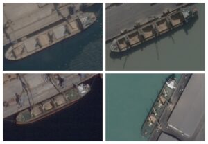
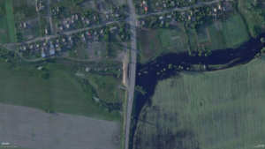
Russia Satellite imagery Satellite Imagery Reveals Russia Caused Flooding in Occupied Ukrainian Town Before Counteroffensive
Hackathon Tech Team Investigating India’s Army, Instagram Location Searches and Handling Traumatic Imagery: Here are the Results of Bellingcat’s Third Hackathon
Chronolocation Social Media Chronolocation: Determining When a Photo was Taken Using Facebook, Google Street View and Assorted Tiny Details
Colombia Lucas Villa: Cell Phone Data Gives New Insight into Unsolved Case of Colombian Protestor’s Killing