Visualising Tree Cutting, Air Pollution and Mudflows in Kyrgyzstan: Bellingcat’s First Hackathon Where Everyone Was A Winner
In early October, Bellingcat’s Tech team organised its second ever in-person hackathon, this time in Naryn, Kyrgyzstan with the theme “Visualising Nature’s Stories”.
This student-only hackathon, in collaboration with the University of Central Asia, saw 30 participants from three international universities in Kyrgyzstan put their heads together to brainstorm ways to communicate one of the most urgent issues of the region.
There were five teams in total: Data Bars, Mountain GOATs, JashylData, Vozduhanny and Trefoil.
Central Asia, which is one of the most vulnerable regions to climate change impacts, experienced devastating storms and landslides, severe heat waves, droughts, and wildfires this year. Smog is a particularly pressing matter in the winter: Kazakh, Kyrgyzs, and Uzbek cities often top the World Air Quality Index Ranking as some of the most polluted cities in the world as households and local power plants burn cheap, low-quality coal to keep warm.
For the first time, we decided to hold a hackathon without juries or winners, as we believe that participating and working on a project on such an important topic is already winning.
To equip participants with skills we deemed useful for the hackathon, Bellingcat provided a workshop on open source research, verification, geolocation, mapping services, and visualisations before the students began working on their projects.
We were happy to see how they were able to apply new skills they picked up at the workshop – whether tracking changes in Google Earth Engine or making visualisations with Datawrapper – to their own projects.
In addition, we invited local journalist Nurlan Tasmaev from Radio Free Europe/Radio Liberty (RFE/RL) to observe the hackathon for potential findings that could be published. This resulted in an article on one of the projects, which visualised the scale of tree cutting along a road in Naryn, being published on the website of RFE/RL’s Kyrgyz Service.
We’re proud to present all of the projects that resulted from this hackathon below, with a brief explanation of each one. We hope that these inspire more open source researchers to find creative ways of visualising environmental issues.
Tree Cutting for Road Expansion in Naryn by the Data Bars Team
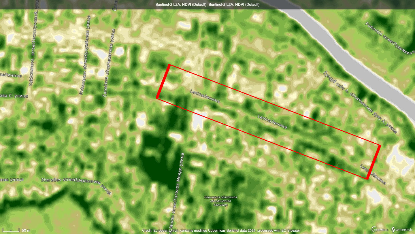
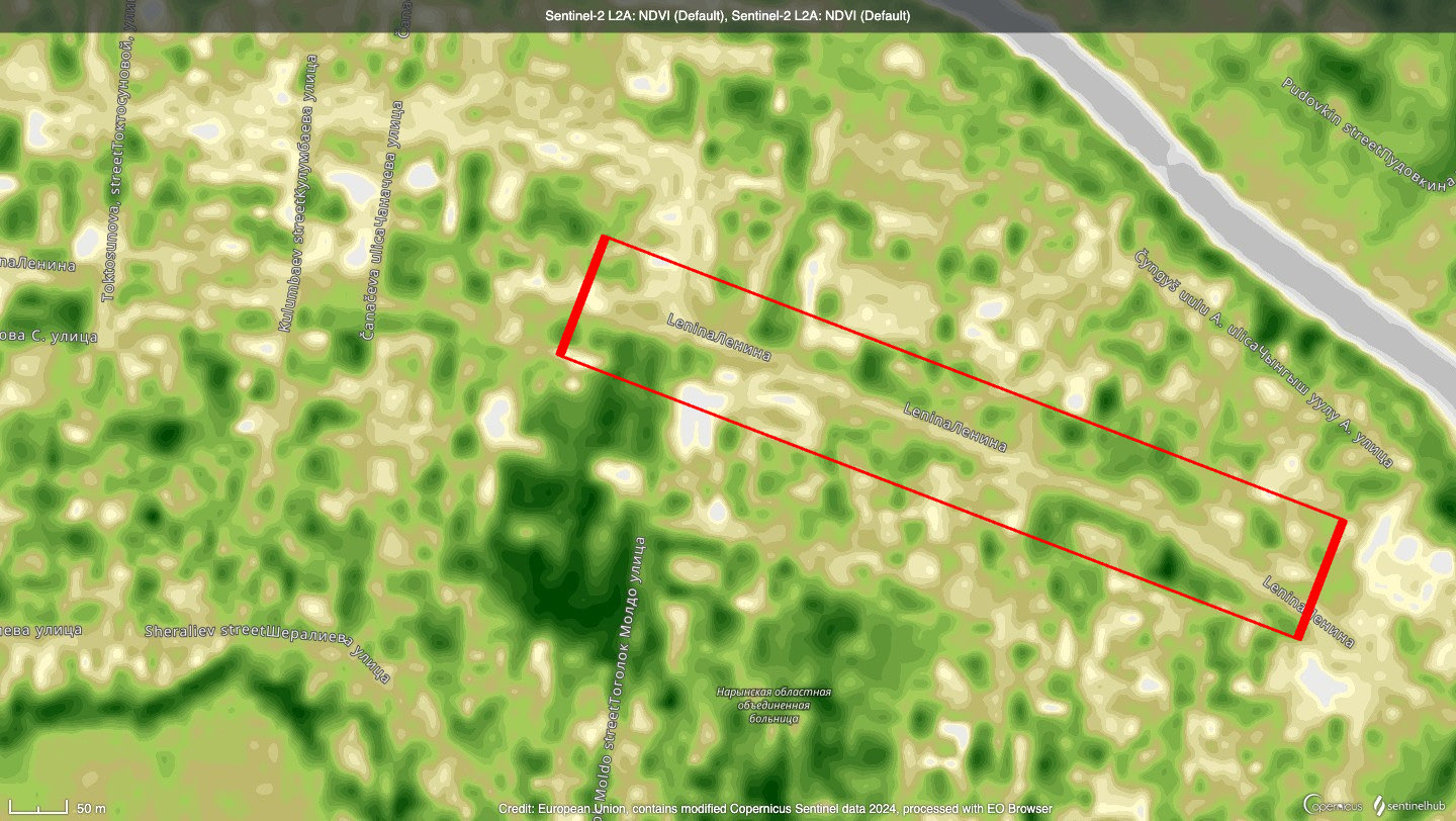
In Naryn, the hackathon location, there is one main road. While walking we could not help but notice all the fresh tree stumps on both sides of the road.
The Data Bars Team were able to visualise the scale of trees disappearing along this road using satellite images, public CCTV cameras, social media photos, and even some field work.
While the changes to trees lining the road were barely visible on satellite images, they could be clearly seen using Sentinel’s Normalized Difference Vegetation Index (NDVI), which uses both visible and invisible wavelengths of light captured in a satellite image to measure the greenness and density of vegetation shown.
In just 10 days in September 2024, a road covered in green turned completely beige when visualised with the NDVI.
Mudflows in Kyrgyzstan by the Mountain GOATs team
This year, Kyrgyzstan registered an unprecedented increase in the number of mudflows, or the downhill movement of soil mixed with rain or snow. In August, strong mudflows flooded 497 residential buildings in the Issyk-Kul region.
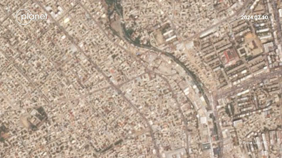
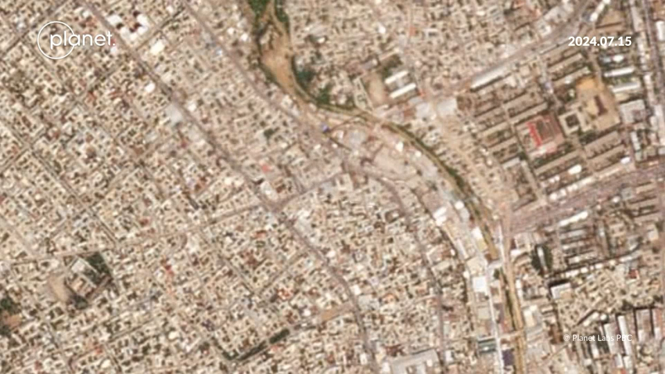
Since authorities have said that heavy rains are one of the main causes of mudflows in the country, the Mountain GOATs team looked into the historical precipitation rates in the country. They zoomed in on a period of heavy rain in July 2024, and using satellite imagery from Planet, the team was able to show the flooded areas in Osh city, with a river noticeably turning brown from mudflows.
NO2 Air pollution by JashylData
On cold days in winter, it is common to see a dense smog enveloping Bishkek, the capital of Kyrgyzstan.
The team JashylData used Google Earth Engine to visualise the Nitrogen Dioxide (NO2) concentration in Kyrgyzstan in the past four years and revealed extremely high concentrations of the gas, which is mainly produced by the burning of fossil fuels, in Bishkek as well as some concentration in Osh region, in the south of the country.
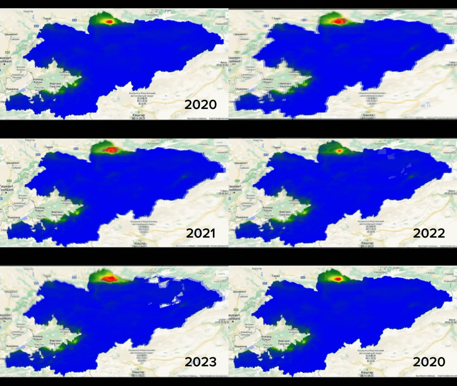
Exposure to high concentrations of NO2 has a severe impact on human health especially on respiratory disease.
PM2.5 Air pollution by Vozduhanny
Another team, Vozuhanny, also looked into the air pollution in Kyrgyzstan, but unlike JashylData, they focused on a different air quality measurement – PM2.5 levels. This measurement, of particulate matter of less than 2.5 micrometres in diameter, is associated with toxins that are small enough to enter the bloodstream and be transported around the body.
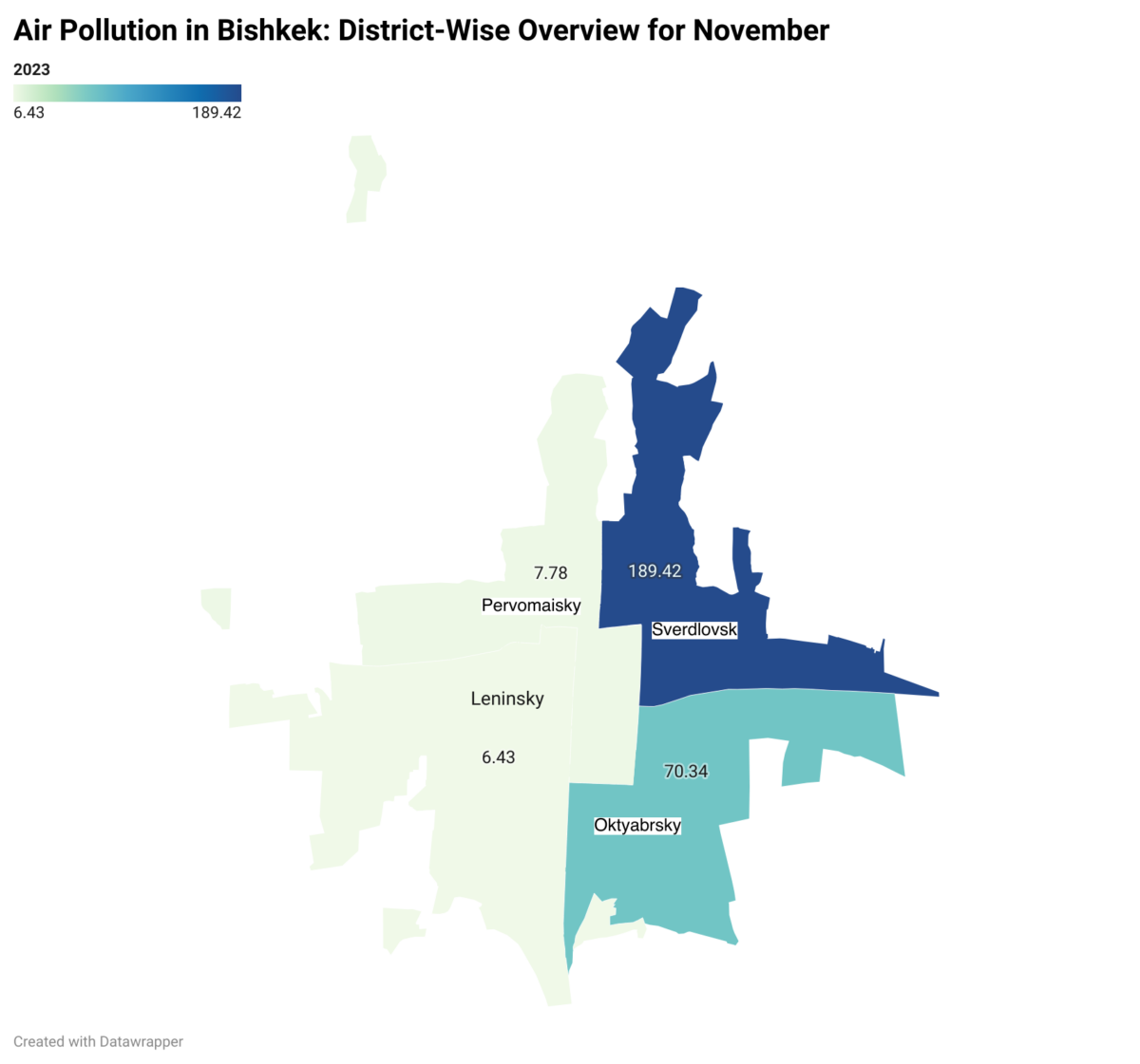
Vozduhanny analysed PM2.5 levels, as reported by The World Air Quality Index Project, in February 2024 and visualised them on a district level. They found that Oktyabrsky district had the highest PM2.5 levels in February.
Semipalatinsk Test Site by Trefoil
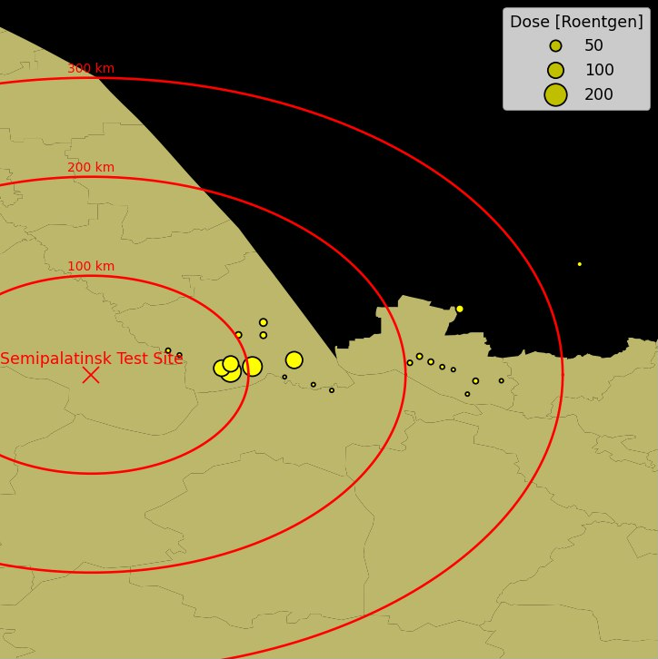
Finally, the Trefoil team looked into the Semipalatinsk Test Site in Kazakhstan, which was the Soviet Union’s main nuclear testing ground from 1949 to 1989. Over 450 nuclear tests were carried out and over 1.5 million people were affected by radiation exposure during that period.
Using declassified data from the Defense Threat Reduction Agency, Trefoil visualised radiation levels in the villages around the Semipalatinsk test site.
Bellingcat is a non-profit and the ability to carry out our work is dependent on the kind support of individual donors. If you would like to support our work, you can do so here. You can also subscribe to our Patreon channel here. Subscribe to our Newsletter and follow us on Twitter here and Mastodon here.
