How to Use Free Satellite Imagery to Monitor the Expansion of West Bank Settlements
Since the beginning of 2024, the US has issued a series of sanctions against a small number of Israeli settlers for jeopardising peace and security in the West Bank. The impact the sanctions will have is debated, but it marks a new development amid ongoing attempts to address widespread Israeli settlement of the West Bank which is illegal under international law.
The first Israeli settlement was established in the West Bank in 1967 after the territory was captured by Israel in the Six-Day War. Today there are now reportedly 500,000 Israeli settlers living in the West Bank. Settlements range from small enclaves to large, well-developed communities and urban areas. According to the United Nations Office for the Coordination of Humanitarian Affairs, 2023 was the deadliest year for Palestinians in the West Bank since the UN began recording in 2005. In March, the Office of the UN High Commissioner for Human Rights concluded that the region was on “the brink of catastrophe”, noting:
“The transfer of wide administrative powers relating to settlements and land administration from the military authorities to Israeli civilian officials, who are elected and accountable to the population of Israel, could facilitate the annexation of the West Bank.”
To research the scale of the settlements and developments over time, analysing satellite data is key. While you can pay for high resolution satellite imagery to gain detailed, on-the-ground information about changes in the West Bank, free-to-access satellite tools can also be useful for examining settler expansion in the West Bank. Although Google Earth imagery of the region has often been of poorer quality, compared with other services and regions, it can still be effectively used – as long as its shortcomings are kept in mind. In addition to Google Earth, Sentinel Hub EO browser is also a useful free service. Both of these were used by Bellingcat in our recent collaboration with Scripps News investigating the conflict in Gaza and escalating tensions in the West Bank.
In this guide we provide a breakdown of free-to-access satellite tools and how they can be used to monitor West Bank settlement expansions.
Introduction to Google Earth Pro
Google Earth Pro is a free tool that allows you to travel virtually anywhere in the world!
This tool gives you satellite images of the earth and is widely used here at Bellingcat because it provides tools for measuring, analysing and displaying geographic data. You can read more Bellingcat guides to Google Earth Pro, here. One of its best features is that it provides historical satellite images. You can compare historic and recent imagery to view changes in land use and infrastructure development over time. It is useful for researchers with an interest in monitoring urban expansion and environmental changes such as those occurring in the West Bank. The amount of historical images depends a lot on what area of the world you’re looking at. The most recent satellite images for Washington DC for example are from March 2024, the most recent images from Jerusalem or the West Bank are from 2022, well before the recent Gaza conflict. Despite the limited amount of recent imagery, Google Earth Pro can still be useful for researchers looking at the region.
How to use Google Earth Pro to Monitor Urban Expansion
First, you’ll have to download Google Earth Pro on your device, you can download it here.
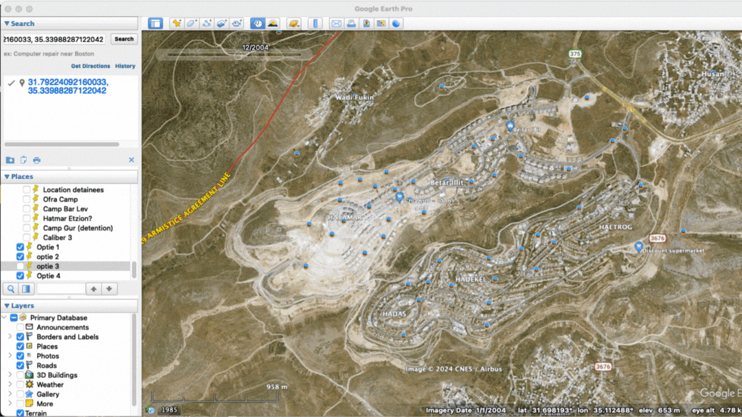
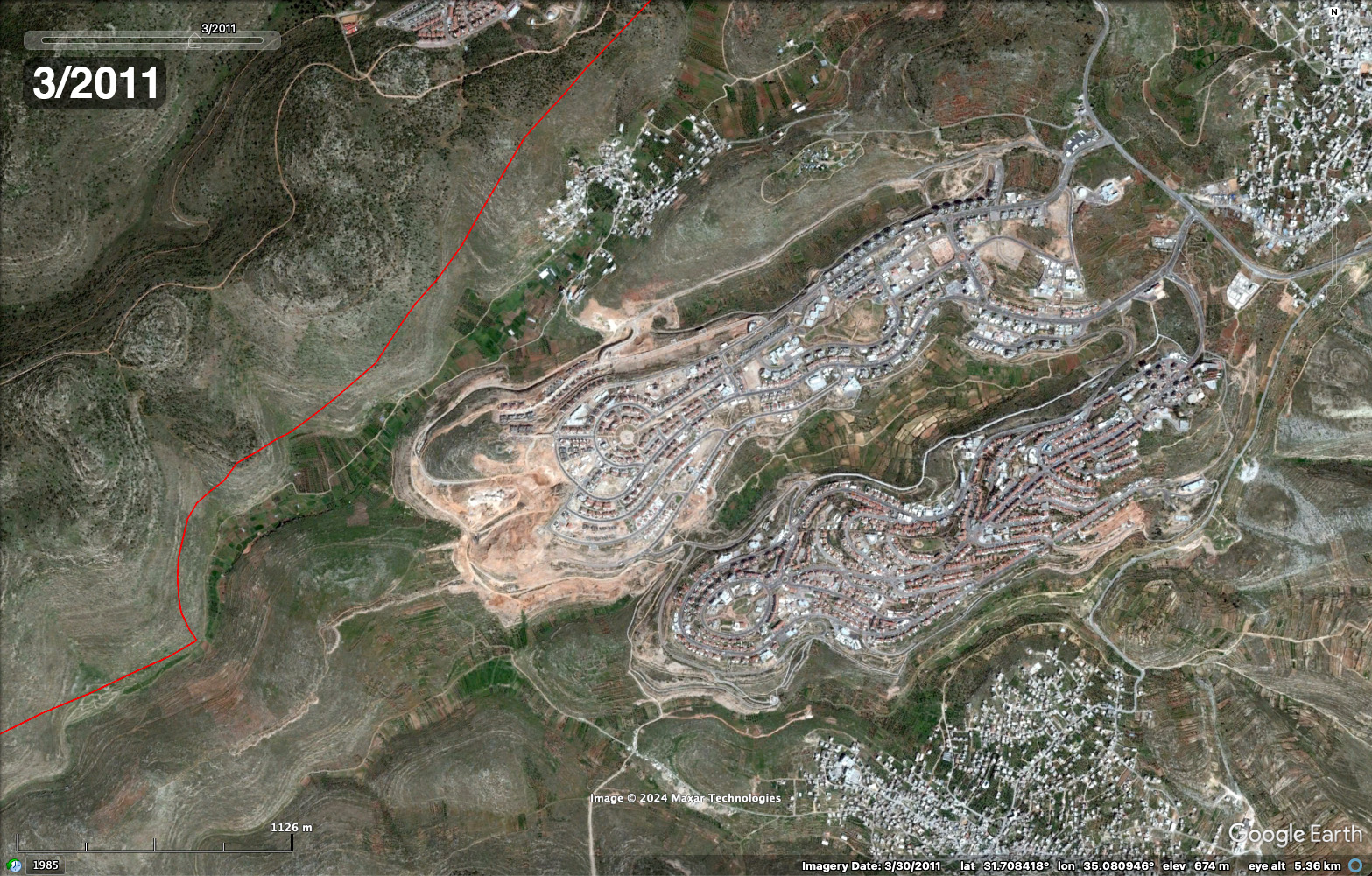
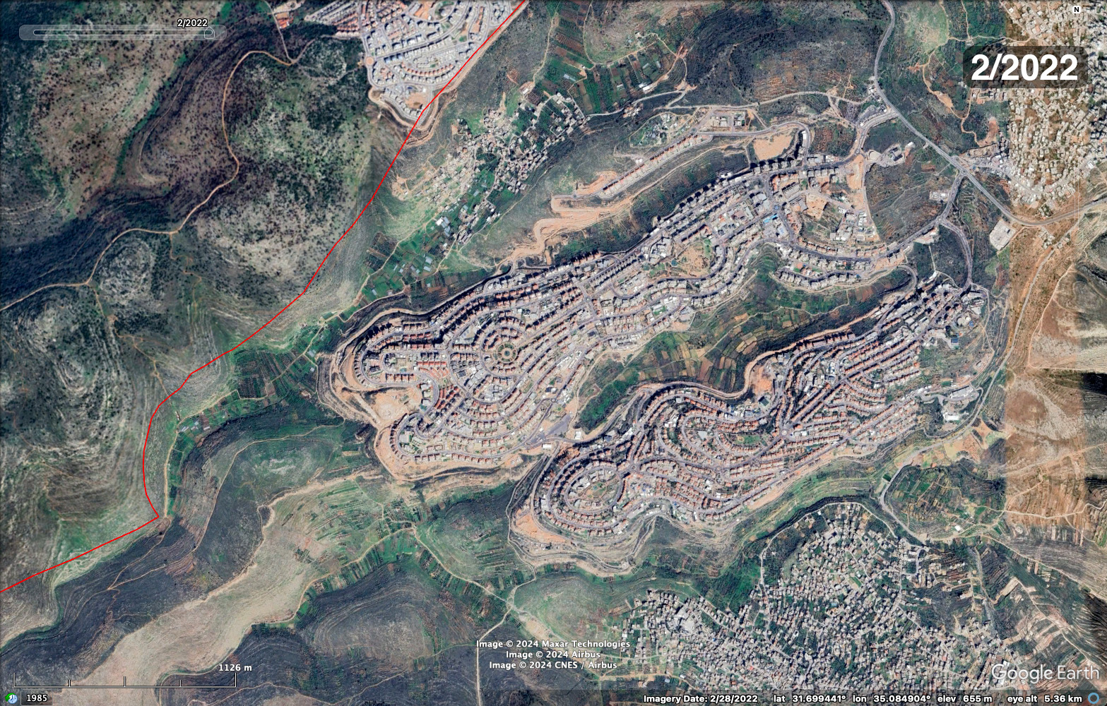
In Google Earth Pro, enter the coordinates of the area you want to take a closer look at. At the top of your screen, you should see an image of a small clock. Once you click that, a slider should appear on your screen. Using this slider, you can scroll through historical images, the range for this particular area is from 2004 as the first clear image to 2022 as the most recent.
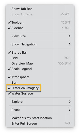
If the clock isn’t visible go to the ‘View’ tab at the top of your screen and check that the option for ‘Historical Imagery’ is selected.
Using this slider to go through the historical satellite imagery can assist with researching the change in landuse.
However, keep in mind that the range of historical satellite imagery depends on the location, some areas have more recent imagery than others. This also depends per settlement, some have images from 2021, others from 2022.
Another Option: Google Earth Engine Timelapse
The Timelapse tool can also help detect changes on the ground and spot earthworks and developments. It allows us to observe trends over long periods of time. The website gives you the option to visit a location and see a timelapse of the area from 1984 to 2024.
The timelapse gives a good overview of an area and the changes that took place over the year- you can often make out structures or roads appearing when looking at areas of suspected settlements and expansions. The downside to using this tool is that the resolution is low and the timelapse can not be downloaded as a GIF or MP4.
Introduction to Sentinel Hub EO Browser
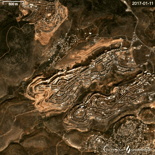
If you need to monitor multiple, large areas, a good alternative to Google Earth Pro is Sentinel Hub EO Browser. Sentinel Hub EO Browser is a web based tool that provides us direct access to a large collection of satellite images collected by the European Space Agency’s Copernicus Programme. You can explore large amounts of data and monitor environmental and human-induced changes.
Although the quality of the satellite images is lower than Google Earth Pro, they are captured with greater regularity. For the West Bank region, Sentinel Hub provides a snapshot every five days, helpful for those looking to mark changes over time. Another useful feature of Sentinel Hub is the possibility to create a timelapse of a certain area you are interested in.
How to use Sentinel Hub EO Browser to Monitor Urban Expansion
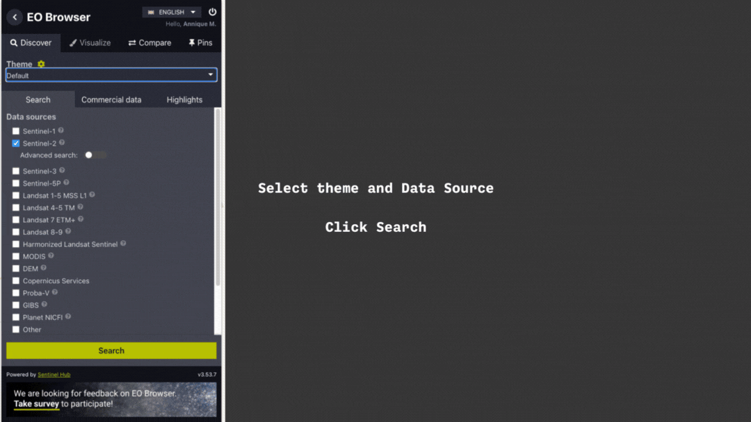
Sentinel Hub EO Browser is very easy to use. Begin by selecting the theme and data source. For the example above, we selected the default theme and the Sentinel-2 Data source. But Sentinel Hub has several other useful themes that can be used to monitor changes to the earth, you can find more about using Sentinel Hub to detect infrastructure changes, here.
Once you’ve selected the theme, data source and inputted your location, you can see a calendar on the left side, if you click on it you can see on which dates Sentinel has a capture available.
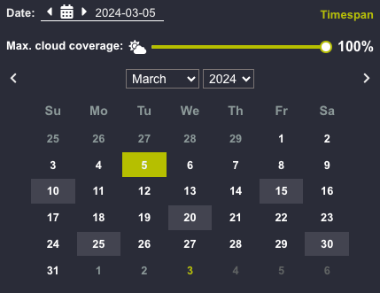
By using the left/right arrow next to the calendar you can scroll through the captures and see if any significant changes took place in the area.
If you want to create a timelapse, these are the steps you need to take:
When an area of interest is vast, a timelapse can help you to discover possible changes that you might not spot in static imagery. The timelapse can be downloaded as a video file, a benefit when comparing with Google Earth Engine Timelapse.
You don’t have to pay to use Sentinel Hub, but if you want to create a timelapse, you’ll need to sign up for an (free) account.
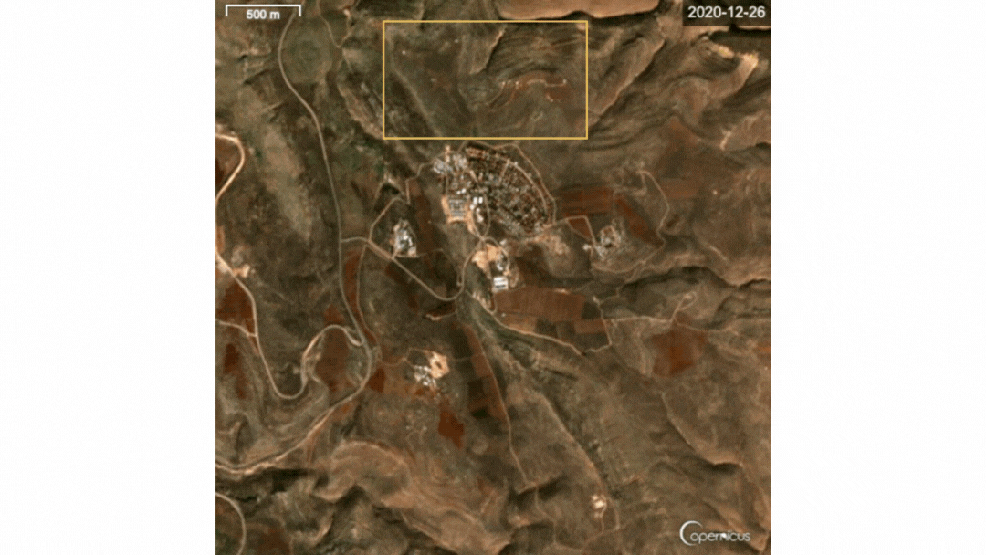
With Sentinel Hub EO Browser being a free tool, the quality of the satellite imagery is very low if you want to have a closer look at a certain area.
Analysing Satellite Images
When examining satellite data, it’s important to understand what you are looking for. A common mistake made by new users is to misinterpret objects and elements in the imagery. To successfully decipher satellite imagery, numerous components, patterns and elements within the image ought to be inspected in detail. Pay attention to changes in the area, the clearing of land, the buildings or roads for example. Sometimes, changes on the ground are obvious, as in this recent BBC piece on the bulldozing of Sharma Village to make way for the Saudi city of Neom. Other times you cannot see clearly on satellite images whether it is actually a constructed building or if construction is still in process. If this is the case, it can help to keep a close eye on shadows. If a tall building, or tall object is built, it will cause a shadow to appear on a snapshot, that we can then use to help measure development and even time and distance.
Another sign of development to search for are changes in the landscape or vegetation. When keepings these elements in mind while looking at satellite images, it can assist you to see the changes in an urban area that might indicate an expansion of a settlement.
The more often you look at images like this, the more trained your eye becomes at spotting differences and changes to the landscape. You become more familiar with its features, and new objects or roads stand out.
Being able to properly interpret satellite images is a matter of practice.
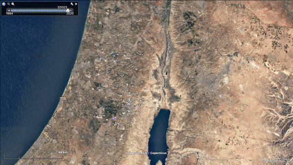
This timelapse of the Kochav Hashahar settlement is a good example where more subtle changes can only be seen only when comparing historic satellite images with new captures. The expansion of the settlement, highlighted in the recent Scripps News documentary, is indicated by the new roads created in the last four years.
Other Useful Resources for Monitoring West Bank Settlements
There are many other free, open-source databases on West Bank settlements that researchers can also use to track expansions. The UN Office for the Coordination of Humanitarian Affairs (OCHA) provides a file named “Settlements in the occupied Palestinian territory” and was last modified on June 3rd 2021. The file was created by OCHA and Peace Now. You can download the file which plots Israeli settlements in the West Bank. Bellingcat has previously used this to track the expansion of settlements. You can download the OCHA file here as a .sph file, a file type which can be converted to .kml by using this website. Once you’ve done this, you can open the file in Google Earth Pro, which allows you to see the settlements on the map of the West Bank.
How to Import a KML File onto Google Earth
After you downloaded the file, you need to unzip it. The folder will contain 8 files and you will need all of them to convert it to .KML. Go to the conversion website and upload the whole folder. Now you can download another zip file which will contain the .KML file.
Drag the .KML file on your Google Earth Pro and drop it in the middle of your screen, once uploaded, the file should be visible on the left side of the screen. Google Earth will move towards the right location automatically and it should look similar to the example below.
When you upload it in this way, the file is stored in the ‘Temporary Places’ folder in Google Earth Pro and this folder deletes itself when closing the program. If you want to save it for research purposes, drag the file to the folder above titled ‘My Places’.
A number of NGOs also track the expansions of settlements on the West Bank, including activist group Peace Now whose resources include databases, regular reports and maps covering settlement expansion. They have also created a mobile app which you can use to track settlements.
In regions that are difficult to access due to ongoing conflict, such as Gaza and the West Bank, analysis of satellite images can provide crucial information about what is happening on the ground. However, analysing satellite imagery effectively requires practice. It’s important not to jump to conclusions based on satellite data alone. We recently wrote a guide on some common mistakes to avoid when starting out in open source research. But the more practice you get looking at the area of interest, the more adept you’ll become and picking out consequential changes in the satellite imagery.
This type of data may appear overwhelming at first, but it doesn’t require specialist training or pricey subscriptions. There are many free tools and resources available to those who want to monitor events from above.
Bellingcat is a non-profit and the ability to carry out our work is dependent on the kind support of individual donors. If you would like to support our work, you can do so here. You can also subscribe to our Patreon channel here. Subscribe to our Newsletter or follow us on Instagram here, YouTube here, Facebook here, Twitter here and Mastodon here.