New MH17 Photograph Geolocated to Donetsk
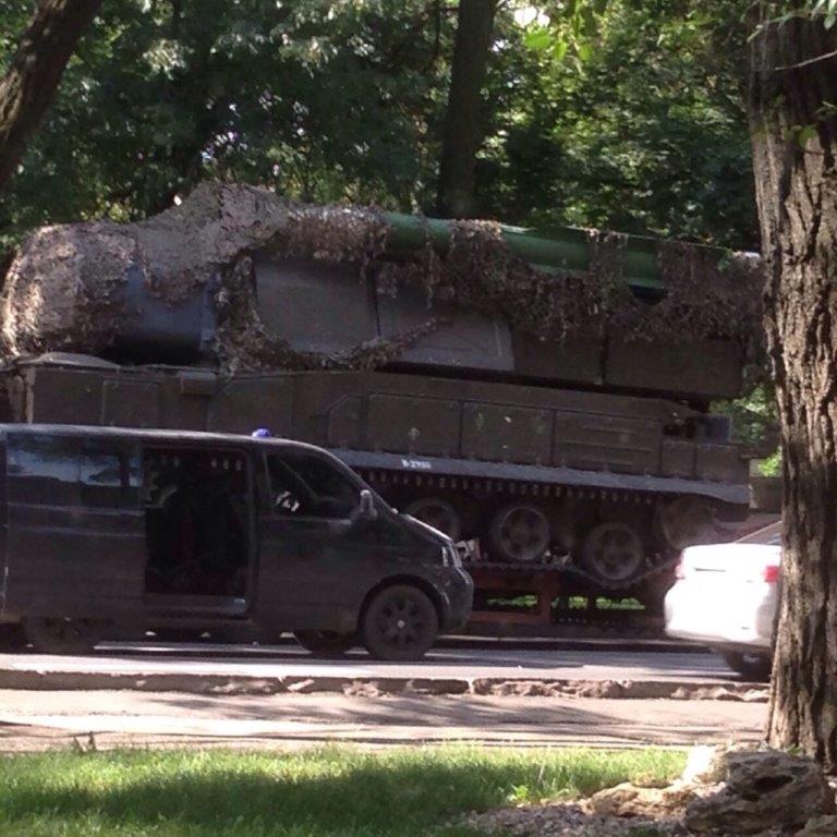
On October 19, 2017, the Joint Investigation Team (JIT), the Dutch-led criminal investigation into the downing of Malaysian Airlines Flight 17 (MH17) over Ukraine, published a new photograph Buk 332, the Russian Buk missile launcher that downed MH17 on July 17, 2014. Buk 332, previously identified by Bellingcat as ‘Buk 3×2,’ is an anti-aircraft missile launcher belonging to Russia’s Kursk-based 53rd Anti-Aircraft Missile Brigade. The image shows the right side of the Buk, loaded on the red low loader. In publishing the photograph, the JIT wrote that the photograph was “probably taken on July 17, 2014 in the town of Makeevka, Ukraine,” but we can now conclusively say that the photograph was actually taken at 78 Prospekt Ilycha, at the intersection with Shakhtostroiteley, in Donetsk.
The Hunt
Using Check, a crowdsourced verification platform, we asked our readers to contribute tips regarding the location of this photograph so that we could collectively geolocate this key piece of evidence concerning the downing of MH17.
Geolocating this #MH17 photograph seems impossible, but we already have a lead. Help us to crowdsource this task: https://t.co/OuZcd7fZbA pic.twitter.com/2P90SHMhxw
— bellingcat (@bellingcat) October 19, 2017
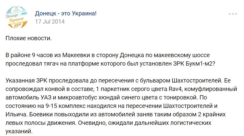
One of the strongest candidates was 78 Prospekt Ilycha in Donetsk, due to previous witness accounts identifying a Buk missile launcher with its Russian/separatist convoy at this site.
Source (Archive)
“Bad news. Around 9am, a hauler was going along the Makeevka highway from Makeevka in the direction of Donetsk. On the platform was a BukM1-M2? This AAMS proceeded to the intersection with Shakhtostroiteley Boulevard. The system was accompanied by a convoy that was composed of 1 gray Rav4 SUV, a camouflaged UAZ, and a dark blue Hyundai van with tinted windows. As of 9:15am, the vehicle was located at the intersection of Shakhtostroiteley and Ilycha. The militants got out of their cars, blocking 2 of the far left lanes. Obviously, they were waiting for logistical guidance.”
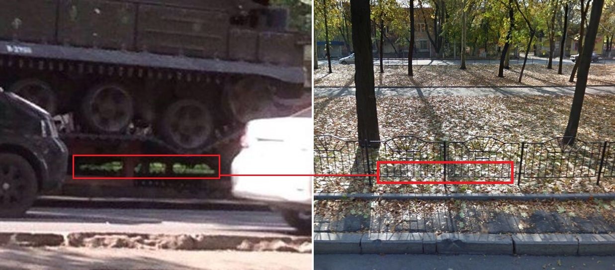
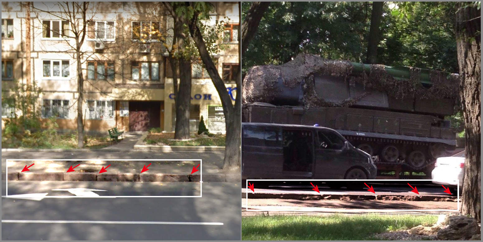
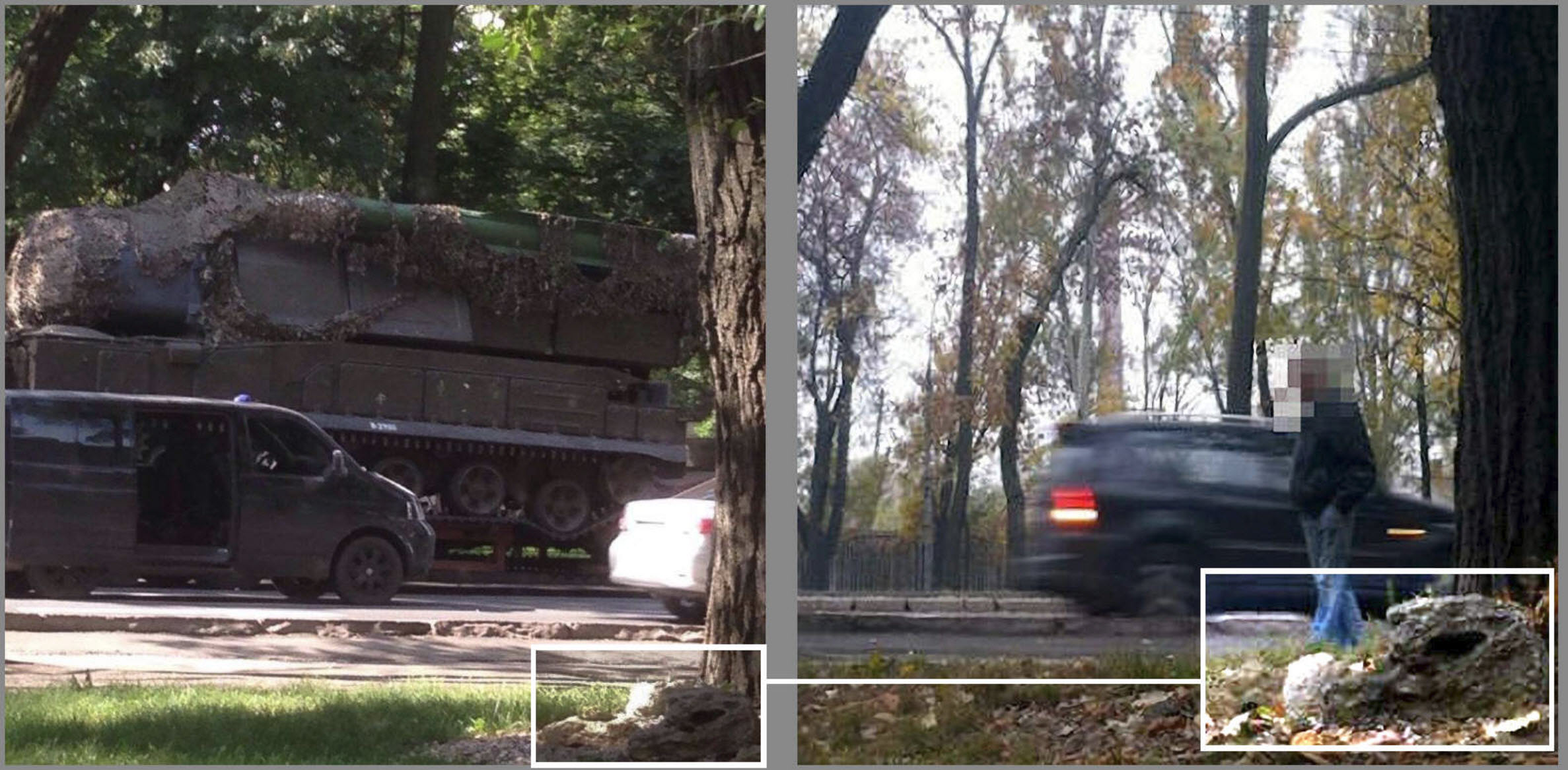
Numerous features in the photograph were also visible in Google Street View and Yandex Panorama imagery of the same location, including the two trees in the foreground, a gate beneath the Buk’s low-loader, a rock next to the nearest tree, and notches in the curb blocks.
Our first guess is in Donetsk, at the intersection of Sakhtostroiteley and Ilych (near a beauty salon). Weigh in at the Check page. pic.twitter.com/1TlxxgEAtT
— bellingcat (@bellingcat) October 19, 2017
The walkway along the salon, where cameraman stood, is much lower than the curb, which explains low position of camera on the "BUK" picture. pic.twitter.com/xTb37YesAF
— Zitty (@zitty055) October 20, 2017
One of the branches behind the hauler looks the same as a tree on Google Maps. pic.twitter.com/1pKh0N3eJq
— Wout Mager (@Eworm_) October 19, 2017
Looking the other side becomes even clearer; this is at the Illicha Ave in Donetsk. #mh17 pic.twitter.com/TkYpW0O665
— Roelard Smit (@ROELart) October 20, 2017
99% a match pic.twitter.com/mbwHxG5ohE
— Lorenzo Romani (@lorenzoromani) October 19, 2017
Taking these tips together, the following comparisons show how some key details match between the two photographs, making the site worthy of further investigation to confirm the geolocation.
Left: A part of a gate visible in an open space through the red low loader, just under the Buk missile launcher.
Right: the same type of gate visible on October 2011 Google Street View of Prospekt Illycha in Donetsk, Ukraine.
Left: The new Buk 332 photograph with a thick tree, a slanting branch of another tree, a little rock and notches in the curb, all marked in red.
Right: the same landmarks in Google Street View marked in red.
Conclusive Evidence
Today, at least one local in Donetsk snapped two photographs from this same location, attempting to confirm or refute a geolocation to Prospekt Ilycha in central Donetsk. These photographs were shared online by Christo Grozev and Rudy Bouma.
Photo from same location TODAY proves @bellingcat & global volunteers were on target pic.twitter.com/TyENGC7qaI
— Christo Grozev (@christogrozev) October 20, 2017
And here is a more comprehensive angle from today pic.twitter.com/KiQL3aAras
— Christo Grozev (@christogrozev) October 20, 2017
(1) Pictures I had made today in DNR are placing new picture of #Buk in Donetsk, not in Makeevka like @JITMH17 is suspecting. #MH17 pic.twitter.com/yNOTfTyxcM
— rudy bouma (@rudybouma) October 20, 2017
(1) Gisteren vrijgegeven foto Buk lijkt op foto's die ik vandaag liet maken niet in Makeevka (zoals #JIT vermoedt) maar hier Donetsk. #MH17 pic.twitter.com/oJGyGqkvd6
— rudy bouma (@rudybouma) October 20, 2017
Conclusion
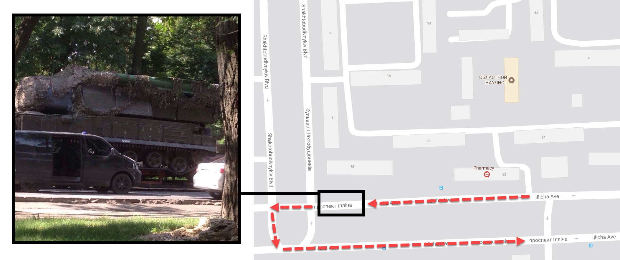
With this geolocation, we now have photographic evidence of a scene that was reported on by numerous locals: Buk 332, originating from Russia’s 53rd Anti-Aircraft Missile Brigade, arrived in Donetsk from Makiivka around 9am on July 17, 2014, parked at the intersection of Prospekt Ilycha and Shakhtostroiteley, and then eventually turned towards the east-bound Prospekt Ilycha towards the Motel roundabout in Donetsk. The movement is shown in the map below, with the photographer of the original Buk photo facing south from building number 78.
