Donbas: A Ticking Toxic Time Bomb
Open-source tracking and monitoring of environmental health risks of targeting industrial sites
Additional research and map making by Foeke Postma @FoekePostma
As the fighting between the Ukrainian army and Russia-backed forces re-ignited at the end of January 2017, various news reports highlighted the shelling of industrial sites. Calls by the United Nations and Organisation for Security and Cooperation in Europe (OSCE) warned of a looming environmental disaster if one of those locations storing hazardous chemicals was hit, and could lead to a severe health crisis. This article aims to use open-source and satellite data to identify several sites at risk of shelling, and highlight the environmental health risks associated with such a looming disaster. One fatal mortar or shell could set in motion a series of chemical incidents, which would have a long-lasting impact on the health and well-being of the Donbas’ civilians caught in the crossfires.
A history of violence
The Donbas region has been severely hit by the ongoing conflict since it broke out in 2014. Since the outbreak of the armed violence, thousands of civilians have been killed or injured, and the ongoing shelling in towns and cities continues to put the lives of civilians at risk. Besides the risk of being killed or injured, the ongoing use of explosive weapons in populated areas by all poses a risk to the houses people live in, their schools, hospitals, and services such as water and electricity, which all add up to the dire conditions people live in. A pressing characteristic throughout the Donbas region is the presence of large-scale heavy industry. This adds to the risks posed to civilians through the risk of environmental pollution and related health issues for local civilians. This article focuses on the often overlooked, or at minimum under-reported, risks of the impact of the conflict on the environment.
Prior to the conflict, pollution was already a major issue in the region resulting from of decades of mining and the presence of large-scale chemical industrial sites. According to a World Bank assessment conducted in 2015,
“Donbas is estimated to host about 900 large industrial plants, including 140 collieries, 40 metallurgical plants, 7 thermal power stations, and 177 chemically dangerous operations, including 113 operations that use radioactive materials. Environmentally, the most harmful industry is mining, which comprises 248 mines, many of which are run-down and nonfunctioning. In addition, the region is also traversed by 1,230 kilometers of oil, gas, and ammonia pipelines. By 2002, an estimated 10 billion tons of industrial waste had accumulated in Donbas, equivalent to a total of 320,000 tons per square kilometre”.
The World Bank assessment highlights grave concerns over conflict-related environmental pollution, in particular between 10-20 mines were damaged, creating problems with hazardous waste and water, soil and land contamination. Power plants were hit by artillery and rocket shelling, which could have resulted in both the breakdown of electricity to pumping stations, and release of toxic polychlorinated biphenyl (PCBSs), as well as crude oil spillage. Chemical production facilities and storage sites were also attacked, potentially creating local environmental pollution hotspots. Water supply infrastructure and sewage systems were severely damaged, as were sanitation facilities, which, as the World Bank report noted, could disproportionately impact vulnerable groups, including women, girls, and poor families.
The environmental research NGO ZoI, published an article and general map in March 2017 with an overview of areas of concern in the Donbass region, visualizing some of the locations most at risk. In the meantime, shelling of critical locations continued, adding more sites to the rapidly expending list of potential environmental hotspots. As demonstrated in a previous report on Ukraine on Bellingcat, we identified the huge risks of targeting Water Filtrations Stations in Donetsk, as these locations store large quantities of liquefied chlorine gas.
Data sources on potential environmental hotspots
In order to locate various sites at risk of creating chemical incidents during the ongoing fighting, we used various information sources to check and verify the locations. We looked at locations that have likely stored large quantities of chemicals that could pose a serious public health risks if they were released into the environment due to shellings and explosions. Several open-source tools have been helpful in identifying these sites.
Wikimapia is a useful initial starting point to get a sense where of these industrial sites, waste management locations, water treatment facilities, and mine quarries are located. Subsequently, using the different frontline maps and reported incidents on liveuamap.com, it was possible to see if some of these locations were shelled. A warning should be given that the sources used by this website are not always accurate, thus verification through other sources was performed where possible.
Next, we accessed the online database Evard, which was available on http://danger.in.ua. Yet, at the time of writing this article, the website and database appear to be offline, though some sections can be retrieved through the Archive.org Wayback Machine and Google Cache. This database helped provide an overview of locations, type of chemicals processed at each locations and past-pollution incidents at various locations in Donbas (and the rest of Ukraine). The Google Map overview of the database is still online, and can be found here:
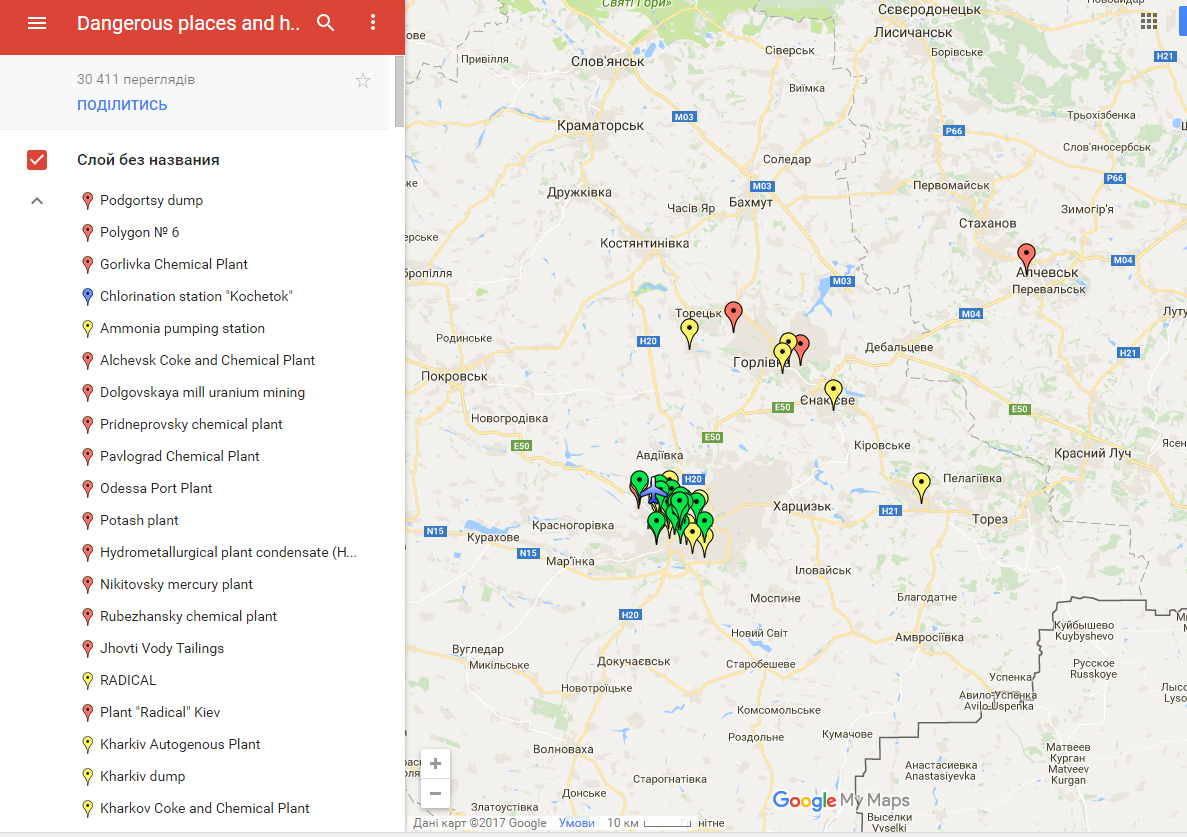
Evard Database of Dangerous sites
Another database we used is the Global Alliance on Health and Pollution’ Toxic Sites and Identification Program, accessible via http://www.contaminatedsites.org. Here we found four sites of interest, with three located in and/or near the frontline. With this information, we could search for either reported incidents or fighting taking place near these locations.Lstly, there is the Unified Registry of infrastructural damage in the Donbas, a private registry run by citizens to identify damage “facilities of social, transportation and other types of infrastructure in the area of military actions in Donetsk and Luhansk Regions”. The website contains names, locations, pictures, and short damage assessments of different sites in the Donbas. Though not an exhaustive list, and in need of verification, it is a robust tool for this research as it categorizes the infrastructure. This in-turn helps us identify and locate specific sites quickly, such as 12 sites related to energy production, such as power plant and transformer station, 48 health/hospital buildings, and 59 industrial sites.
As with previous conflicts, there are also risks of pollution resulting from military activity. Examples of these are uncontrolled explosion of ammunition depots, which has been reported on several occasions, and potential issues surrounding military scrap metal collection sites, which often attract civilians scavenging for valuable materials.
To understand the risk potential, we combined the information on these industrial locations with data from the UNEP/OCHA Flash Environmental Assessment Tool [pdf] (FEAT), a rapid assessment tool that contains information on various hazards and types of risks associated with chemicals, and provides pre-defined estimates of the likelihood of an event, and priority hazards, which can be of help to first-responders. In order to check if shelling or other explosive impacts happened at the identified locations, we used social media reporting to seek confirmation, and consulted the extensive reporting done by the Organisation for Security and Cooperation in Europe (OSCE) Special Monitoring Mission to Ukraine in their database of Daily and Spot reports. If serious incidents were found, satellite data from Digital Globe was used to verify the latest developments in the areas at risk. Other open-source data on industrial sites, critical infrastructure and relevant sites was compiled into a Google Maps overview, which is available here.
In sum, existing pre-conflict mapping of industrial sites combined with frontline reporting helped form an overview of sites at risks of chemical incidents, which can be explored further by linking it to reports on social media, newspapers and daily briefings provided by the OSCE.
Selection of sites
Ongoing shelling from both sides in the conflict near various locations at risk of a chemical incident has substantially increased the chance of such an event happening. For this article, we looked at at the aformentioned databases and news articles on locationss that have been reported to be at severe risk of creating a chemical incident that could pose direct and long-term health and environmental risks to civilians. From this long-list, we selected a short-list based on 1) whether we could locate the industrial site with the information available, 2) whether they were expected to be at risk of shelling, and 3) whether the industrial site is expected to store toxic substances that would pose an environmental risk when the location was being hit by shelling or explosions. In some reports, no site could be located that was of risk. For example, this OSCE report from February 2017 only noted that there were “reports of explosions at industrial facilities and damage in residential areas”, referring to witnesses that noted explosions at “a chemical plant in Donetsk”, even though no specific information was given on the location. There are also a number of low-risk sites located further away from the frontlines, such the Azot chemical plant in Sievierodonetsk, the Zarya chemical plant in Rubizhne, and the Linik oil refinery and storage facility in Lysynchansk. The following sites have sprung up as of immediate risk to being shelled, thereby creating potential risk to the environment and population
Avdiivka Coke Plant
This industrial site has frequently been covered in the news as there were numerous reports of direct hits at the facility. The factory is the biggest coke producer in Ukraine, and in the top 5 in the EU. On its own website, it’s noted that the factory produces various coke related products.
“…from coal tar and coke gas extruded at coal coking process. In particular they are coal raw benzene, electrode pitch coke, electrode coal tar pitch (molten or hard as granules), technical sulfur acid, ammonium sulfate, coal oil, phenolates, naphthalene faction, coke raw material for high-structural technical carbon production.”
In short, the location processes and hosts large amount a wide range of chemical products . At the time of writing this article, Avdiivka reported that 320 shells exploded on the plant territory, and 10 employees have been killed since June 2014, while over 50 have been wounded. According a BBC report from April 2015, the factory is at risk of being targeted by intense shelling because the Ukrainian army uses the location for its own troops
In May 2015, the OSCE reported that the factory was hit by 45 artillery and mortar rounds, creating fires and an ammonium leak. Continues fighting near the coke plant throughout 2016 and 2017 certainly puts this location high on the list of chemical incident risks.
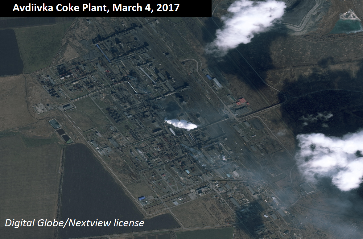
Avdiivka Coke Plant, Satellite Image Digital Globe/NextView License
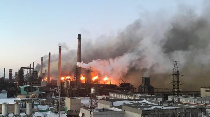
Avdiivka Coke Plant.
Novhorodske Phenol Factory
This factory, located 35km north of Donetsk, uses naphthalene, phenol and other toxic chemicals. Phenol is a toxic substance that is also known as carbolic acid, hydroxybenzene, monohydroxybenzene, among other names. Phenol is a flammable, highly corrosive chemical with a sickeningly sweet, acrid odor. Phenol is well-absorbed by all routes of exposure to the human body, and exposure by any route can cause systemic effects. Various environmental exposure routes, such as groundwater pollution, have been noted in studies.
The chemical waste generated by the on-site production is stored in a reservoir near Novhordoske, and also located in the vicinity of critical water resources. According to the director of the phenol factory, the reservoir, storing carbonated sediment from the chemical process, requires immediate repairs. The OSCE observed that the Ukrainian Armed Forces and forces associated with the self-declared Donetsk People’s Republic (DNR) are separated by 400 meters, with the chemical waste water pond in between them. Concerns have been raised since 2015 over a potential disaster of a direct hit a the factory, which could result in both a health risk to local residents, and wider environmental problems.
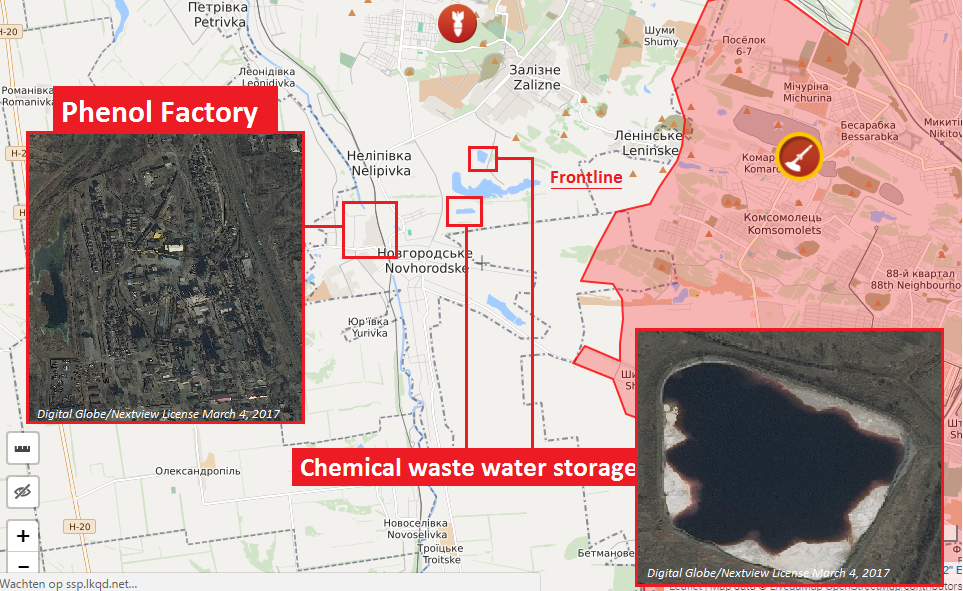
Phenol Factory and chemical waste storage pond
Recent social media coverage indicates that there is still artillery shelling coming from territories held by Russian-backed forces.
#Торецк с 23:42 и сейчас сильный обстрел артой – бьют с Горловки. pic.twitter.com/AA67c6K6LN
— Внутренняя Монголия (@l_vinchenso) March 6, 2017
ATO spox: In the Horlivka perimeter, militants opened fire at UA positions all across the frontline
— UCMC (@uacrisis) March 7, 2017
Water filtration stations near Donetsk
A couple of water filtration stations in the Donbas have seen serious risks of being targeted in the last couple of years A direct hit on these stations could potentially lead to a chemical incident, or pose long-term problems if water infrastructure is damaged, as it would prevent the local population from having access to clean water. For a more in-depth analysis on these sites and wider consequences, see our article “Water Filtration Plants and Risks of a Chlorine Mass-Casualty Event in Donetsk”. We have short-listed three locations below based on the article.
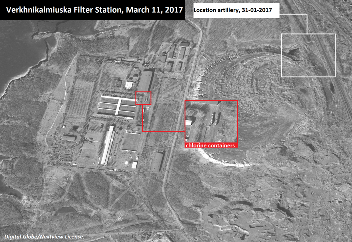
- Verkhnikalmiuska Filter Station (VFS): The facility is based on the southern edge of Yasynuvata. The water filter station contains more than 300 tons of liquefied chlorine stored in pressurized tanks, and used for water disinfection. In the case of an incident, large amounts of chlorine gas could be released and pose an acute health risk in a 200-meter radius, depending on weather conditions and quantities released. Estimates are that in a worst-case scenario, it could potentially affect 400,000 people. Recent satellite images have shown “DNR” forces stationing artillery nearby the VFS, which could poses risks to the locations if these artillery pieces were targeted.
- Donetsk Water Filtration Station (DFS): The DFS is located on the frontline in between Avdiivka and Yasynuvata, and stores 9,000 liters of liquefied chlorine. The site has been targeted on numerous locations and went through the eye of the needle when it comes risks of a chlorine-gas release as a result of a direct hit.
- Gorlovska Filtering Station Nr. 2: This facility west of Horlivka has been shelled numerous times in 2016, leading to a plea from the ICRC to stop targeting these facilities, as over 2 million people depend on the water provided by these facilities.
Mikhailivka Transformer Station (MTS)
This transformer station is part of the HVDC Volgograd-Donbas power supply route, and provides electricity to the villages situated in the so-declared area of the Luhansk People’s Republic (LNR), with some villages including Zolote, Pervomaisk, Irmino, Stakhanov and Kiroysk. Recent reporting indicates that the water supply to the factory has been shut down, which could have consequences in the case of a fire. This type of power plant utilize various toxic materials as part of the energy production process. The locations host 12-valve bridges, each containing mercury diodes. The location has 100 diodes, each containing 32kg of mercury at the locations, thus in total hosting 3.2 tons of mercury. The current frontline is located 2km from the MTS, and in previous OSCE reports, several incidents of shelling were noted in the nearby village of Zolote, indicating a continuous threat of escalation that could affect this site.
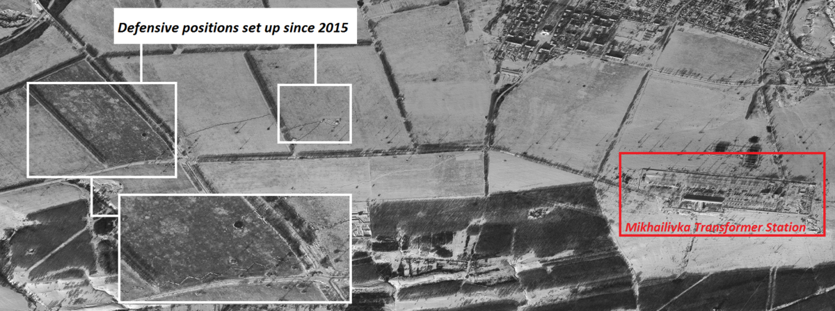
Mikhailyka Transformer Station Defensive Position
Bakhmut Agrarian Union
The Bakhmut Agrarian Union is a large-scale livestock farm, located in the village of Novoluhanske, hosting over 94.000 pigs, and a poultry stock of around 310,000 generating large quantities of untreated waste. Prior to the conflict, the waste water was treated on-site and dispersed over the nearby lands. At the moment, shelling, and resulting erxplosive remnants of war, as well as mines in the area have prevented this process. This resulted in the accumulation of untreated waste in a nearby pond which has a capacity of storing over 1 million cubic meters of waste water. Reported shelling on the location puts this pond at risk of collapsing, which could result in a local environmental risk, and is in dire need of repairs.
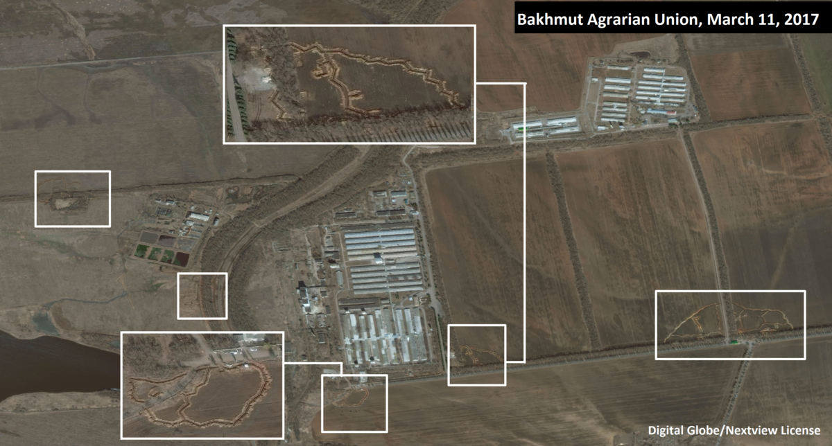
Defensive postions at Bakhmut Agrarian Union
Early January 2017, Ukrainian Armed Forces retook the pig farm in a swift move. More problematic is the recent move by the Ukrainian forces to dig themselves trenches at the site and surrounding fields. Satellite images from March 2017 show various trenches and defensive positions being set up, which could turn this site into a military target for separatists. Reports already indicate the farm was targeted several times by LNR forces.
23:20 [#Toretsk area] @zakon18022014 Incoming rounds in the area of #Zaytseve–#Semyhirya–#Kodema. Very heavy, it even dings
— English Luhansk (@loogunda) March 21, 2017
Northwest of Novoluhanske is another site at risk: the Vuhlehirska Power Station. The plant was allegedly targeted over a 100 times with 152mm heavy artillery shells by LNR forces in 2015, which led to severe damage to the facility. Cut off electricity to civilian areas and industrial sites could both exgravate humanitarian problems due lack of heating and other electricity needs, or absence of power for various systems used in mining activities such as pumping stations. This could result in flooding of the mines and further environmental contamination.
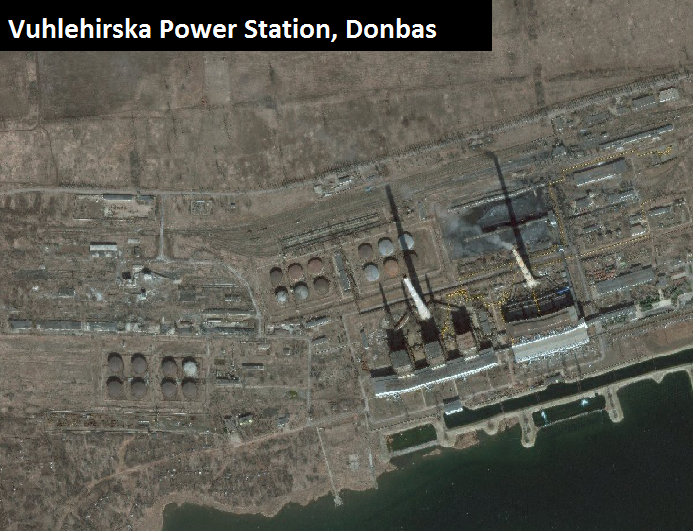
Source: Bing maps
Nikitovsky Mercury Mine Plant
The Nikitovsky Mercury Mine Plant is a well-known toxic hotspot due to of decades of mercury mining. As of today, there are five abandoned mercury mines at a depth of 40 to 180 meters, a waste dump, and closed mercury high concentrations of mercury in the soil and water. The location is tagged in the first danger category with regulatory sanitary zone of 1000. A report on Worldwide Mercury Hotspots notes that the disease incidence of population continues to grow and locals still continue to conduct open gardening near the site. Vegetation and crops are likely to have strong elevated of mercury uptake.
There are no known reports of the site being shelled, despite being close to the frontline. However, controls, or the enforcement of restrictions on access to this site, are absent, and thus could exacerbate exposure to civilians entering the area or utilizing the soil for community gardening.
Luhansk Thermal Power Plant
The Luhansk thermal power plant is located northwest of Luhansk, providing electricity to the city of Luhansk and surrounding villages. In 2014, local Ukrainian Armed Forces commanders stated that they mined the factory and threatened to blow it up if separatist forces advanced and attempted to take over the factory.
Several incidents with shelling of the power plant have been reported since the outbreak of the conflict that inflicted damage or led to a halt of operations. Power plants can host large quantities of PCBs, which could result in local pollution of soil and water if the factory was indeed damaged by attacks.
#Pictures
Substantial damage from Russian shelling of the #Shchastya power plant last night.#UkrainUnderAttack pic.twitter.com/QXCmrUdYTe— Julian Röpcke (@JulianRoepcke) August 6, 2015
Uncontrolled explosions ammunition storage sites
Apart from direct health risks associated with blasts of ammunition depots, research indicates that there might well be long-term environmental problems due to the spread of munition-originated heavy metals and other toxic munition constituents. Historical incidents with unplanned explosions at munitions sites show the potential for water and soil contamination as a result of widespread uncontrolled dispersal of a range of munitions and explosives. As a recognised problem around gun ranges or manufacturing and disposal facilities, efforts to predict the risk munitions residues may pose have generated a complex debate surrouding dose-effect relationships, human exposure pathways, mixture toxicology and environmental behaviour. Decades of civilian and military research into the health hazards associated with firing, manufacture and disposal have demonstrated that long-term consequences for humans and the environment are feasible.
Several incidents occurred in the Ukrainian conflict, ranging from the shelling of munition factories to uncontrolled explosions of stockpiles, either as a result of sabotage or bad management practice. In September 2014, there was a huge explosion at the Donetsk State Factory of Chemical Products. This location, in separatist-held territory southwest of the Donetsk Airport, hosts various workshops, including the production of explosives. More incidents at the same location occurred in October 2014, February 2015, and in February 2017. Additional unverified reports of munition dumps explosions indicated incidents took place in 2016 in Zeytsevo, near Gorlivka; in 2015 in Svatove, Luhansk. The latter explosion set of 3,500 tons of ammunition, which affected 10,000 people in nearby villages who needed support of the Ukrainian Red Cross for emergency shelter and food.
On March 22, 2017, a huge explosion took place in an ammunition depot in Balakliya, located in the Kharkiv Oblast, northwest of separatist-controlled territory. The blast set off multiple explosion at the site, which reportedly was storing 138,000 tons of ammunition. According to an initial statement by the Ukrainian government, the explosion was set off by saboteurs, possibly with use of a drone equipped with explosives, although mishandling of munitions could very well be the actual cause. Lack of safe storage and management of munitions have historically been a main cause of explosions, rather than attacks. Social media footage seemed to indicate open storage of a range of munitions crates, mortars, and artillery shells.
https://twitter.com/MaidanKharkiv/status/844866756782964739
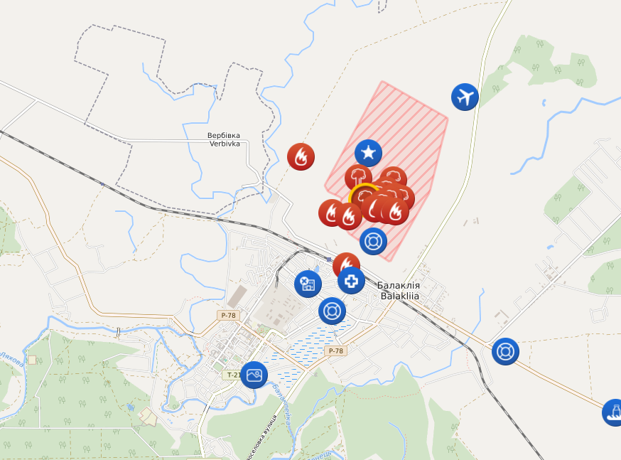
LiveUAMAP Balaklyia
The above-described incidents reaffirmed that munition stockpiles create explosive risks to local communities, and that these depots should be monitored for long-term planning. Such an assesment will have consider heavy metal pollution and other toxic risks associated with munition pollution that could pose soil and groundwater pollution. A recent press statement by the Ukrainian Ministry of of Ecology and Natural Resources on the Balaklyia blast affirmed the need for environmental rehabilitation.
Other conflict-related environmental risks
The collapse of environmental governance and the absence of law enforcement in the Donbas have also led to the increased dumping of chemical waste. The OSCE reported in August 2014 that civilians have protested against the illegal dumping of toxic waste around Stryi, concerned that it would affect their health. Environmental research undertaken by a regional inspection agency showed that high levels of lead, copper and cadmium were present in the soil of suspected dump sites. It’s likely this has occurred more often since July 2014 due to the absence of controls and inspection.
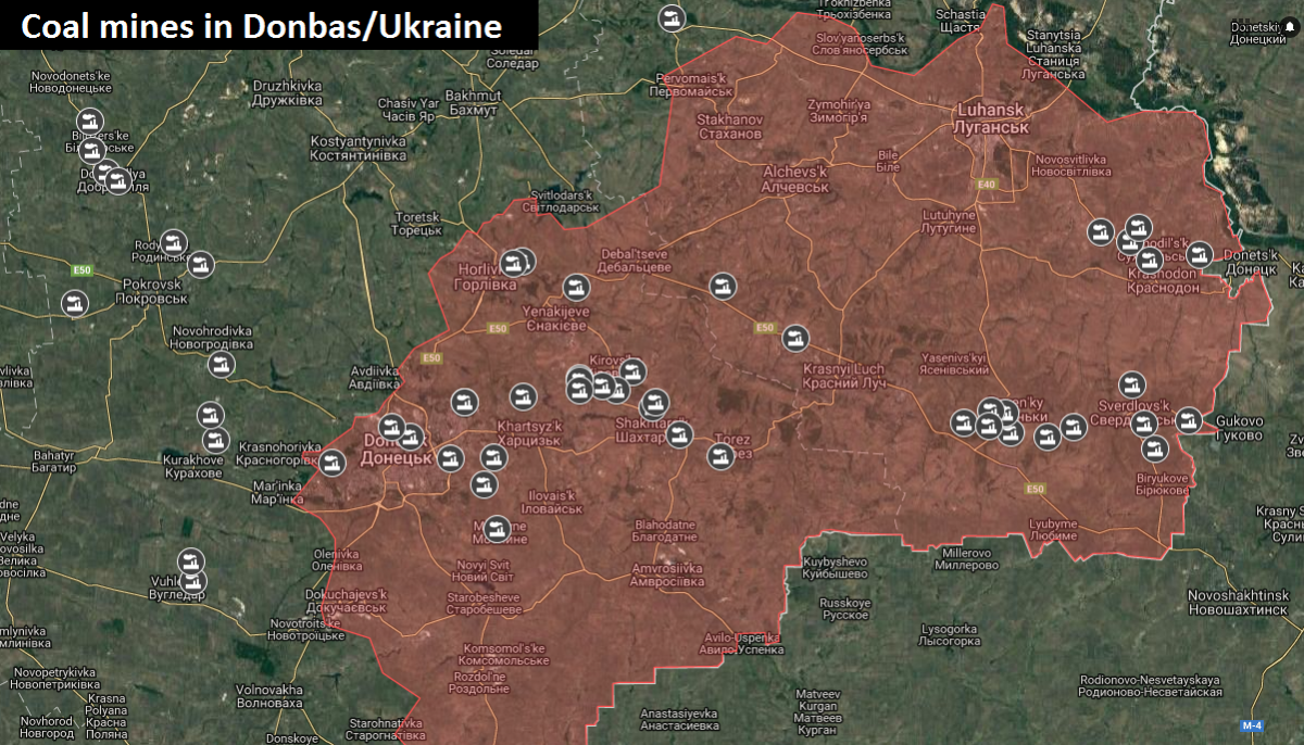
Lastly, the Donbas’ industry is heavily reliant on mining activities. As noted by the World Bank report, Ukraine used to operated 138 mines. Recently, experts analysed [PDF] and underlines the risks of flooded mines due to absence of management and break down of pumping station due to electricity cuts (that could be caused by targeting power plants). It is estimated that there are 35 flooded mines, including one nuclear site in Yenakiyvo, while other flooded mines could result in poisoned and sometimes radioactive waters polluting the Siverskyi Donets River and Azov Sea, while strontium isotopes can flow into the Black Sea.
Classifying risk? Applying the Flash Environmental Assessment Tool (FEAT)
Proper environmental impact assessment of the above-mentioned locations is needed to assess the real impact. With data on the specific type and quantity of chemicals stored, conditions, exposure, and impact site, a real assessment can be done. In the meantime, we used the FEAT to highlight the likely environmental threats and hazards associated with damage to the locations.
Disclaimer note: Many of the substances presented in the table can appear in various forms, and thus could have different exposure pathways and health and environmental risk associated with these varied exposure types. Furthermore, it is not always clear if the noted substances were indeed present at these facilities, yet it is merely a generalisation of the hazardous substances usually found at these locations.
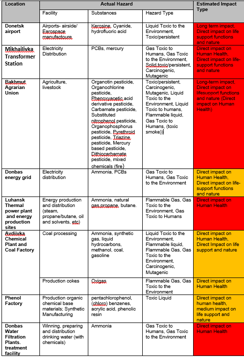
Hazard Identification Table Donbas
Recommendations
The ongoing violent conflict in Ukraine has already caused thousands of civilian casualties, and have forced people to flee their homes and villages. As described in this article, the conflict also brings severe risks to the environment in the Donbas region. The region was already struggling with past pollution issues as it hosts hundreds of heavy industrial zones and a number of chemical factories, producing thousands of tons of toxic, chemical waste. As the war continues, many of those sites have been hit by mortar fire and heavy artillery fire and others are endangered to the same fate. These locations are ticking toxic time bombs, waiting to burst. Apart for the obvious call to find a political solution, both parties should immediate cease their hostilities on and around these locations, as to prevent a chemical incident from taking place. As we highlighted in our previous article on Donetsk chlorine risks, there are several international processes that aim to address conflict-related environmental damage, such as the UN Environmental Assembly, the International Law Commission, and the work done by UN Special Rapporteurs on environment, human rights and toxics. Part of the outcome of these processes is the call to improving response to prevent further pollution and health risks to communities. A recent comment from early Mach 2017 by the UN Special Rapporteur on Toxics and Human Rights further outlined these risks, stating that:
“Large chemical and industrial facilities are in areas where fighting is ongoing”, said Baskut Tuncak, the Special Rapporteur on human rights and hazardous substances and wastes. “Battles are now being fought in cities, close to industrial centres, with factories increasingly becoming at risk of being hit: the consequences for anyone living close-by would be severe. (…) Most of Ukraine’s industrial facilities are located in the eastern part of the country. These include heavy industrial infrastructures operating in the mining, metallurgical, chemical and power sectors. The presence of a range of explosive and toxic substances at these sites is a source of serious concern.
Therefore, the call in the UN Environmental Assembly’s resolution on Protection of the Environment in Areas Affected by Armed Conflict to ‘cooperate close on preventing, minimizing and mitigating the negative impacts of armed conflict on the environment’ must be echoed here, and both sides of the warring parties should be well aware that a continuation of hostilities around these environmentally sensitive sites could lead to chemical disasters far beyond their capacities to deal with in times of armed conflict. The toxic consequences would therefore be the burden of civilians living in the affected areas to carry.
I would like to thank Rachel Salcedo, Roos Boer and Foeke Postma for additional edits and feedback.
