Russia's Colin Powell Moment - How the Russian Government's MH17 Lies Were Exposed
In the year since the shooting down of Flight MH17 in Ukraine on July 17th 2014 there have been many different theories about who was responsible and the exact circumstances under which MH17 was shot down. For much of that time those theories have fallen into two broad categories, that either a separatists controlled Buk shot down MH17, or a Ukrainian military aircraft. Since the official criminal and Dutch Safety Board investigations have begun governments have generally avoided making any specific claims about who was responsible, but in the days after MH17 was shot down governments were making various claims. The US and Ukrainian governments both claimed a Buk missile was responsible, while on July 21st the Russian Ministry of Defence gave an hour long press conference where they presented their evidence of who could have been responsible for the attack.
The press conference covered four main claims:
- That a video published by the Ukrainian Ministry of Interior showing a Buk in separatist controlled Luhansk was in fact filmed in government controlled territory in another town.
- MH17 significantly changed course just before being shot down.
- Radar imagery shows an aircraft close to MH17 shortly after it was shot down.
- Satellite imagery shows Ukrainian Buk missile launchers operating on July 17th.
Since the July 21st press conference it has been possible to establish that all four claims were false, and in some cases involved the Russian Ministry of Defence producing faked evidence to support their claims.
The Luhansk Video
Following the downing of Flight MH17 the Ukrainian Ministry of Interior published a video that was filmed in the separatist controlled city of Luhansk, close to the Russian border with Ukraine, which they claimed showed a Buk, carrying three missiles instead of the usual four, heading towards the Russian border on the morning of July 18th.
In the Russian Ministry of Defence’s July 21st press conference they claimed that the video had in fact been filmed in a government controlled area:
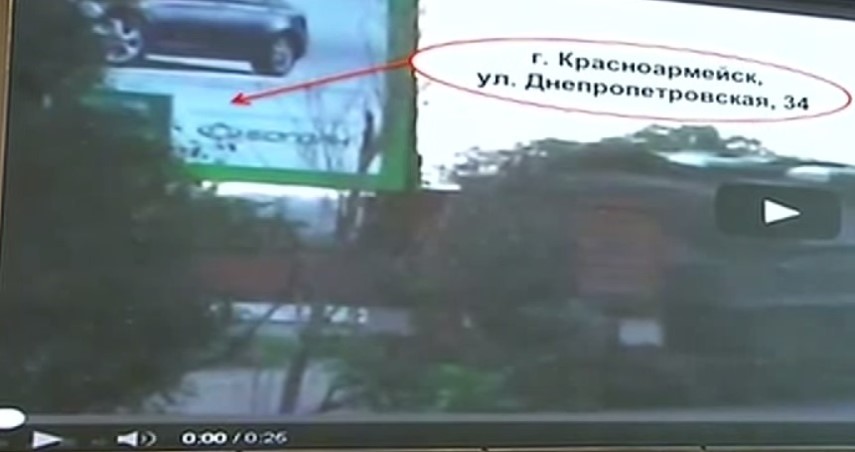
For example, media circulated a video supposedly showing a Buk system being moved from Ukraine to Russia. This is clearly a fabrication. This video was made in the town of Krasnoarmeisk, as evidenced by the billboard you see in the background, advertising a car dealership at 34 Dnepropetrovsk Street. Krasnoarmeysk has been controlled by the Ukrainian military since May 11
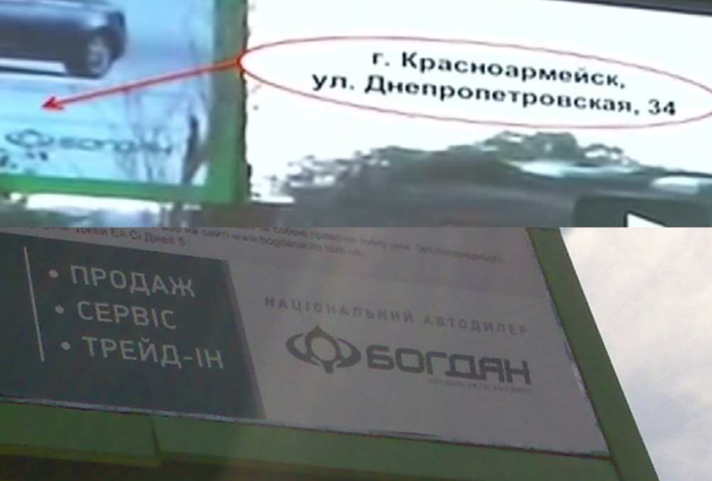
To support this claim they provided an image of the billboard visible in the video, along with what they claimed the line of text read.
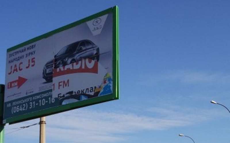
Unfortunately for the Russian Ministry of Defence it was possible to establish the true location the video was filmed using open source investigation techniques, which confirmed the exact location in separatist controlled Luhansk. This location was visited by a Luhansk local who took photographs of the area which both helped confirm the location, and what was written on the billboard.
Here it can be clearly seen that the text on the billboard is completely different from what the Russian Ministry of Defence claimed. This location was confirmed as being correct by journalists who visited the same location, including 60 Minutes Australia and Correctiv, who photographed a very specific piece of vandalism on the billboard.
MH17’s Significant Course Change
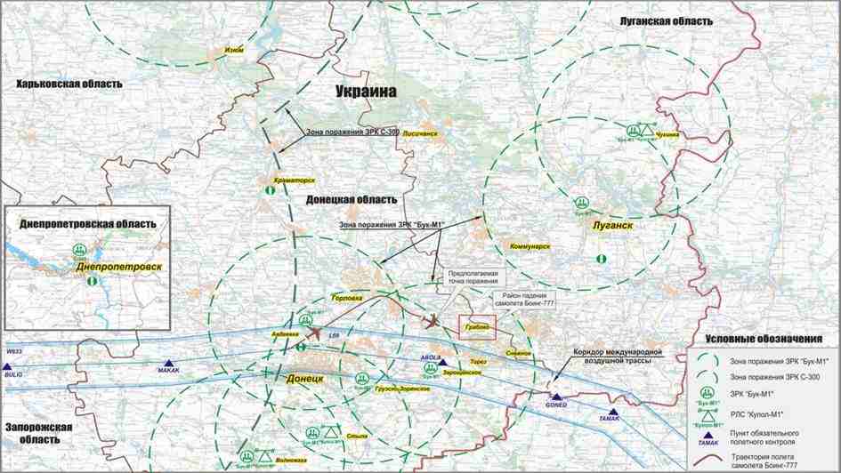
The Russian Ministry of Defence presented the following image during the press conference, claiming that Flight MH17 had been significantly diverted from its course:
The Russian Ministry of Defence stated that:
On the scheme you can see the international airway. The Boeing-777 was supposed to fly on this airway. Draw your attention to the fact that the aircraft followed inside the specified air-corridor to Donetsk, then it deviated from the route to north. Meanwhile the maximum distance from the left border of the air-corridor was 14 kilometers. Then we can see that the Boeing-777 turned back to the borders of the specified air-corridor. Nevertheless Malaysian aircrew didn’t succeed the maneuver. At 17.20 we entered the event of the aircraft rate reduction, at 17.23 the aircraft’s point blinked off on the radar. Why did the aircraft cross the border of the air-corridor? Was it the navigation mistake, or the aircrew followed the Dnepropetrovsk ground control orders? We will find the answers after “black boxes” and communication decoding
The preliminary Dutch Safety Board report did in fact answer the questions the Russian Ministry of Defence asked “after “black boxes” and communication decoding”. The Dutch Safety Board preliminary report in fact showed that MH17 had been on an entirely different course than the Russian Ministry of Defence had claimed, and had not changed course in the way described in the Russian Ministry of Defence imagery. A comparison of the Dutch Safety Board’s flight path and the Russian Ministry of Defence flight path can be seen below.
Again, we can clearly see that the Russian Ministry of Defence is making a claim that is simply untrue, and this is provable using publically available information.
Russia’s Radar Data
The Russian Ministry of Defence also presented radar data that showing Flight MH17, claiming “Russian system of air control detected the Ukrainian Air Force aircraft, purposed Su-25, moving upwards toward to the Malaysian Boeing-777. The distance between aircrafts was 3-5 kilometers.” Chief of Staff of the Air Force Lieutenant-General Igor Makushev was then invited to comment on the radar data.
“At 17.20 P.M. at the distance of 51 kilometers from the Russian Federation state boundary and the azimuth of 300 degrees the aircraft started to lose its speed obstructively which is quite distinctively to be seen on the table of the aircraft characteristics. At 17.21 35 seconds P.M. with the aircraft speed of 200 km/h at the point of the Boeing crash there is a new mark of the aircraft to be seen. The aircraft was steadily monitored by radar stations of Ust-Donetsk and Butirinskoe during 4 minutes period. Air control officer having enquired the characteristics of newly appeared aircraft couldn’t possibly get them because it is in all likelihood that the aircraft had no secondary deduction system amounted on it, which is put typically for military aircraft. The early detection of this aircraft appeared to be quite impossible because the air situation control is usually performed by radars working in a standby mode which detection possibilities at the given distance are over 5000 m altitude.
The detection of the aircraft turned out to be possible as the aircraft ascend it.”
However, radar experts were interviewed by a number of news organisations who gave a different opinion, with Dutch NOS news asking four experts to give their opinions. Comments included “it is really impossible for [it to be] a fighter”, “no aircraft was in the vicinity of flight MH17”, “it seems likely that the signals are the wreckage of MH17”, and “falling debris are the most likely explanation”. Again, another Russian claim that doesn’t stand up.
Russian Satellite Imagery
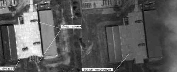
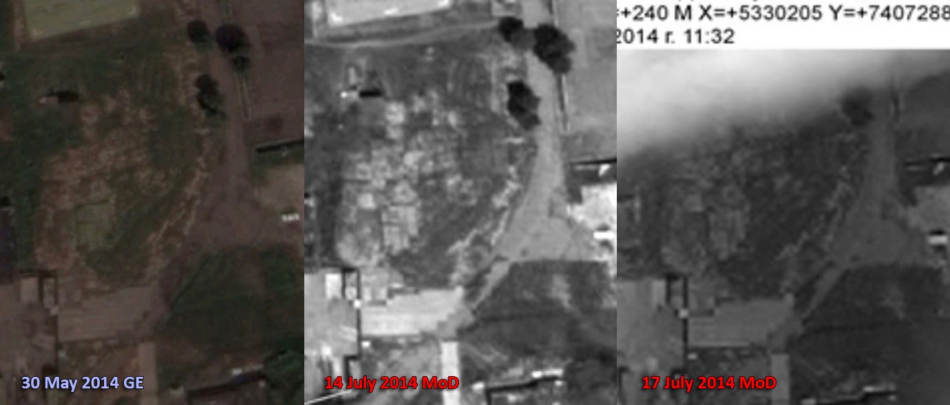
Russia also presented sets of satellite imagery showing three different locations, including two military bases and a field outside the town of Zaroshchens’ke. At one military base, the 1428, it was claimed images from July 14th and July 17th showed that a Buk missile launcher had moved from the base on July 17th.
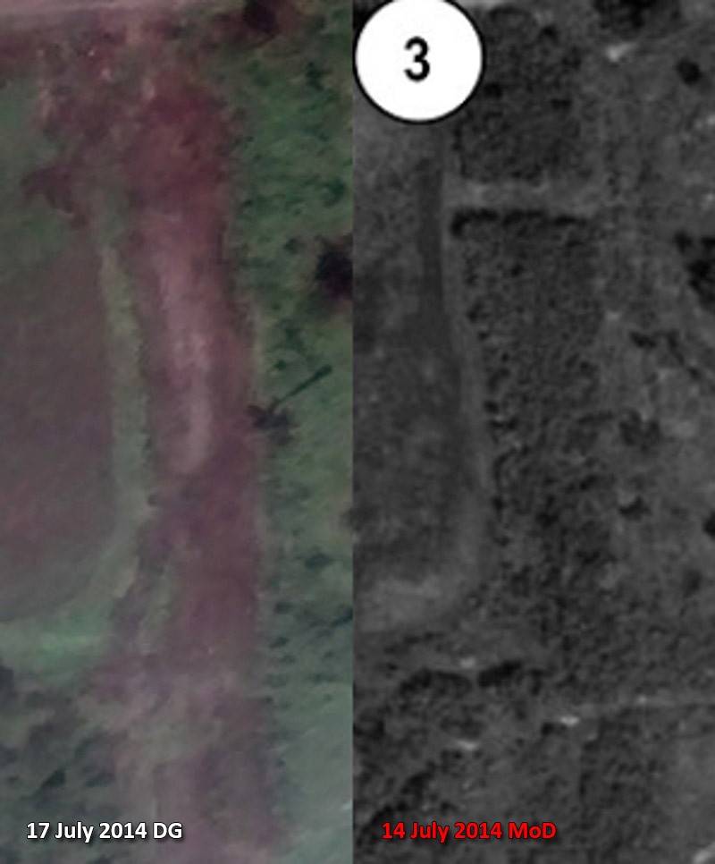
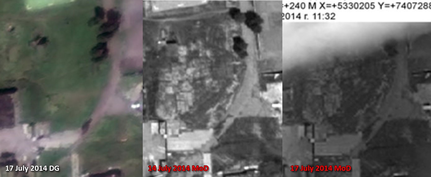
However, it was possible for Bellingcat to purchase an image from the satellite company Digital Globe of the same location on July 17th, and compare that image to the images presented by the Russian Ministry of Defence. For example, large areas of vegetation visible in the July 14th Ministry of Defence images were absent from the July 17th Digital Globe image.
It was also possible to find historical satellite imagery of the same location from July 2nd and 21st of the same area on Google Earth, which confirms the vegetation had be cleared weeks before July 17th.
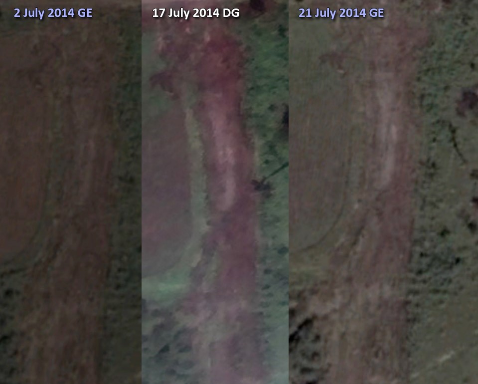
Patches of worn away grass visible in the Russian Ministry of Defence imagery were also absent in the Digital Globe July 17th imagery.
But, as with other discrepancies between the images, the patches of missing grass were visible in earlier historical imagery on Google Earth, clearly showing the Russian Ministry of Defence images were from weeks before MH17 was shot down.
More differences are detailed here, and images of the other areas also showed the dates provided by the Russian Ministry of Defence just didn’t match with publically available satellite imagery of the same areas around the same dates. In addition to that, the Zaroshchens’ke site, where the Russian Ministry of Defence claimed they detected two Ukrainian Buks, was under separatists control on July 17th and locals interviewed by Russian media stated no Buk missile launchers were in the area on that date, and no missiles were launched from the area.
It’s clear that not only did the Russian Ministry of Defence lie about evidence it presented on July 21st, but also presented fake evidence in attempt to place blame on Ukraine for the shooting down of Flight MH17. The July 21st press conference represents nearly all the information the Russian government has presented on MH17 to the public, and it’s clear that the Russian governments reaction to the murder of 298 people was to lie, produced fake evidence, and attempt to deceive the public, the global community, and the families of the 298 people murdered on July 17th 2014. The one big question that remains is whether the Russian government presented this information to the criminal investigation into the downing of Flight MH17.
