The Yemen Project: HAJ 10005 – The Abs Prison Strike
Incident ID: HAJ10005
Location: Abs, Hajjah, Yemen
Coordinates: 15.998964, 43.198856
Incident Grading: Confirmed
Date: 2015-05-12
Time (AST): After 1515 AST
2019/04/26 – UPDATE 1: Report has been updated to reflect new information regarding Building 1
KEY FINDINGS
– Open sources, including satellite imagery, indicate that on 2015/05/12 sometime after 1515 AST two buildings in Abs were destroyed, and other buildings damaged, in an airstrike by the Saudi-led Coalition (SLC)
– Although there were multiple reports of different locations being attacked, it was consistently stated that a prison was one of the targets of this attack. We identified what we believe to be this prison in the report.
– The Joint Incidents Assessment Team (JIAT) stated it had targeted two weapon depots in Abs on 2015/05/13 that it claims were used by the Houthis. The JIAT also claimed that it did not target nor damage the Abs prison, and that the buildings it targeted were 900 meters and 1,300 meters away from the prison, respectively. We identified what we believe the SLC may believe is the prison in question.
DISCOVERY
The sources used in this report were found by searching for variations of “Abs” and “prison” in both English and Arabic across different search engines and social media platforms. Time limitations and advanced searches were used to search specific date ranges around the time of this incident. Searches on YouTube were conducted using the same keywords in both English and Arabic, and videos were filtered by date to aid identification.
The following sources were discovered:
NGO reports
Human Rights Watch (HRW) report
Legal Support Links report
News Reports
Al Mayadeen News report
Social Media
Al Jazeera Facebook Post [statement]
Facebook post [image of injured or dead child]
Facebook post [graphic images of fatalities]
Facebook post [statement]
Republic of Yemen Media Committee against Saudi Attack
The Yemeni Scene Facebook Post [image]
Al Jazeera Tweet [statement about raid at 1538 AST]
Yemen Satellite Channel Facebook post [several images]
Yemen Satellite Channel Facebook Post 2 [several images]
Yemen News Site [images of bodies]
Yemen Youth Council [statement]
Facebook Post [Video of Building 2]
Facebook Post [statement and images saying it’s his brother’s house]
Facebook Post [earliest statement found]
Facebook post [several low quality images]
Facebook Post Eulogy [image of man]
Facebook Post [possible image of strike]
Facebook Post [statement & image of dead child]
Facebook Post [unique image]
Facebook Post [NB – good image of mountains in background]
Tweet [images]
Tweet [unique image]
WHERE?
The incident took place in the town of Abs in the Hajjah governorate in Yemen. The structure which was allegedly hit is known as Abs Prison (also as Abs Shefr Prison, and Abs/Kholan Prison).
Using satellite imagery, we identified three buildings that were almost completely razed in the town of Abs between 2014/01/27 and 2016/07/04. This time period was limited by the regularity of satellite imagery. The identified buildings were:
- Building 1 at 15.99881, 43.19885,
- Building 2 at 16.00041, 43.19460.
- Building 3 at 15.99961, 43.19399.
Of these buildings, there is user generated content posted on or shortly after 2015/05/12 depicting Building 1 and Building 2. Currently, there do not appear to be any images or videos showing Building 3. There are also images depicting a fourth location which suffered heavy damage, Building 4, which could not be geolocated.

Locations, clockwise from top left: Building 1, Building 2, Building 3, Building 4 (satellite imagery taken on 2017/12/01 courtesy of Google/DigitalGlobe)
Building 1 Geolocation
A series of images from various sources depict this building. A set of three doorways can be seen in several images, along with distinctive marks on the wall around these doorways.
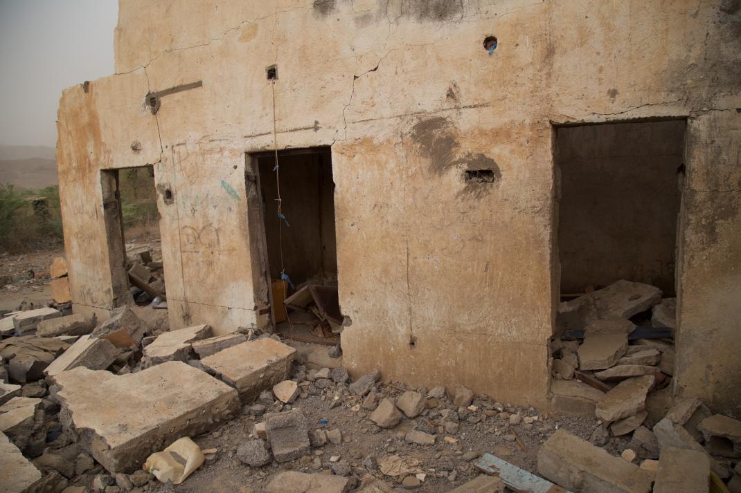
Image from HRW report showing distinctive doorways and marks. (courtesy of Ole Solvang/Human Rights Watch)
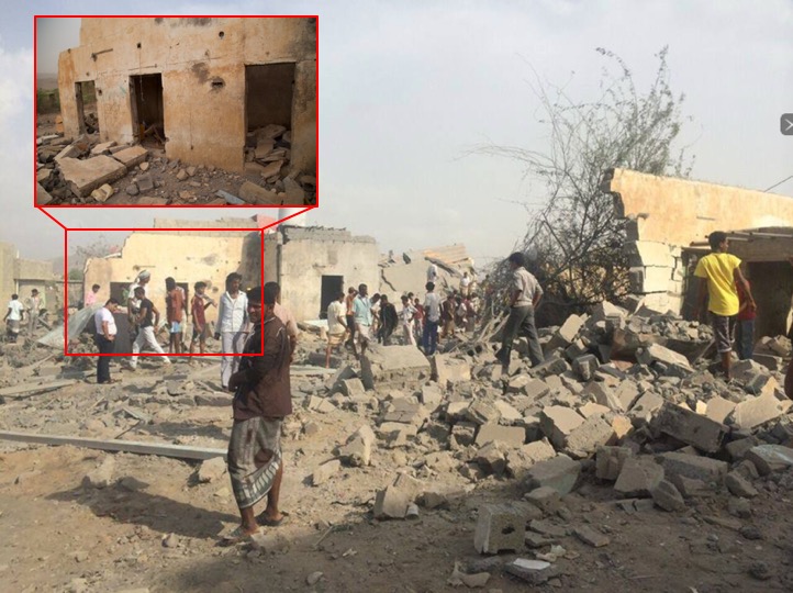
Image from this al Mersad report on the attack. Note that the dots and marks around the doorway match.
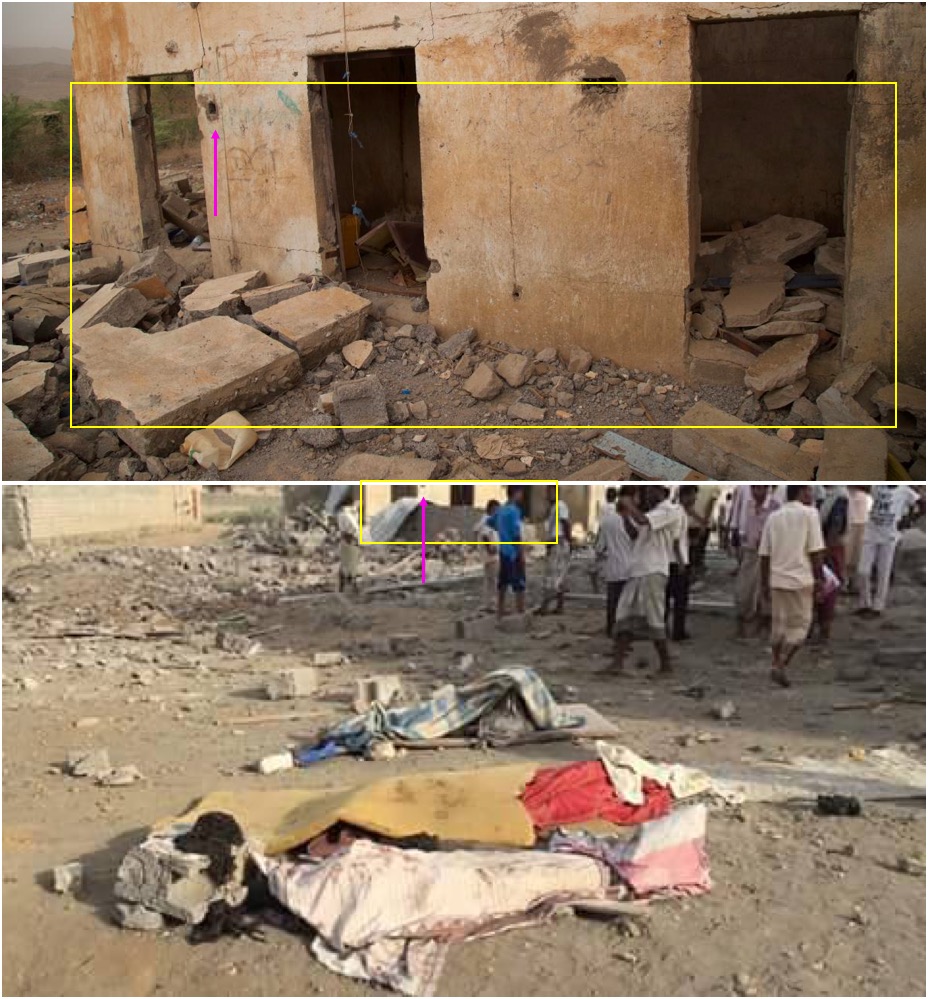
Top: Image from HRW report. Bottom, image from Facebook post. Again, note the three doorways, and the small hole marked by the pink arrow.
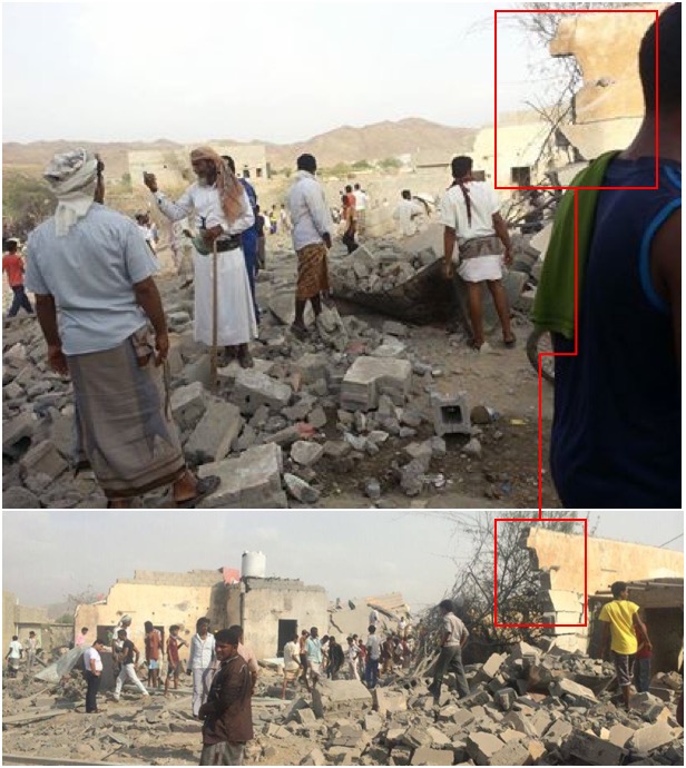
Top: image from Facebook post. Bottom: image from Al Mersad report that we have already established is from this location.
All the images above share certain key features which demonstrate they were all taken in the same place. The features seen in these images can also be seen at the location of Building 1.
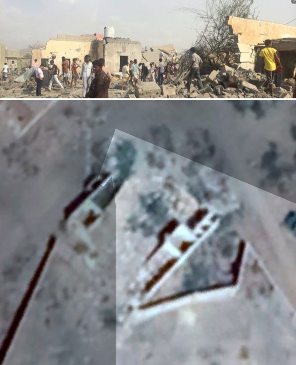
Geolocation of image depicting Building 1. Top: image from Al Mersad report. Bottom: satellite imagery taken on 2017/12/01 (courtesy of Google/DigitalGlobe). Note the three doorways correspond to three rooms on the east side of the compound.
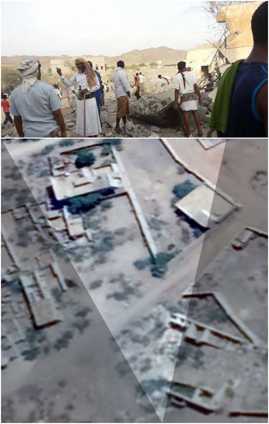
Geolocation of image within Building 1. Top: image from Facebook post, Bottom: satellite imagery taken on 2017/12/01 (courtesy of Google/DigitalGlobe). Note the three doorways to the right of the Facebook image and the tall building on the center left.
Building 2 Geolocation
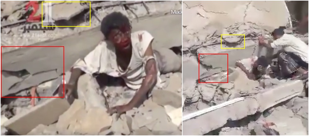
There are two videos from this location, one of which was posted on Facebook by a person named Majed Massoud. Majed may have filmed this video, but it is not possible to be sure with the available information. This video will be referred to as the “Majed video”.
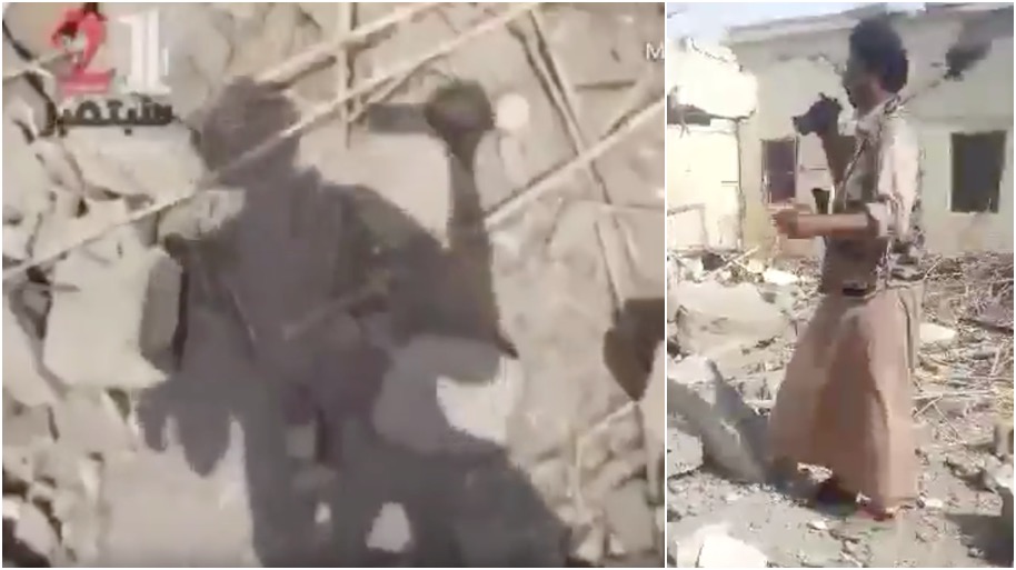
A second video with a 21Sept.com watermark was also taken at this location. This video will be referred to as the 21Sept video. This video may have been taken by a cameraman wearing military-style waist-coat.
We can confirm these two videos were taken in the same place at roughly the same time, as they both film the same casualty in the same location.
It may also be possible to see the cameraman of the 21Sept video in the Majed video. The Majed video captures a man in a military-style waistcoat with a hand-held camera in his right hand at the scene. In the 21Sept video, the camera operator briefly catches their own shadow, showing that they are holding a hand-held camera in their right hand. Therefore, we believe it is likely the man in the camouflage waistcoat filmed the 21Sept video.
The analysis above confirms that at least part of the 21Sept video was filmed at this location during this incident. We will now use the Majed video to geolocate Building 2.
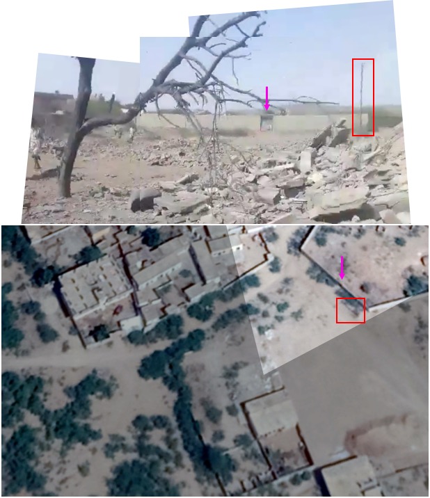
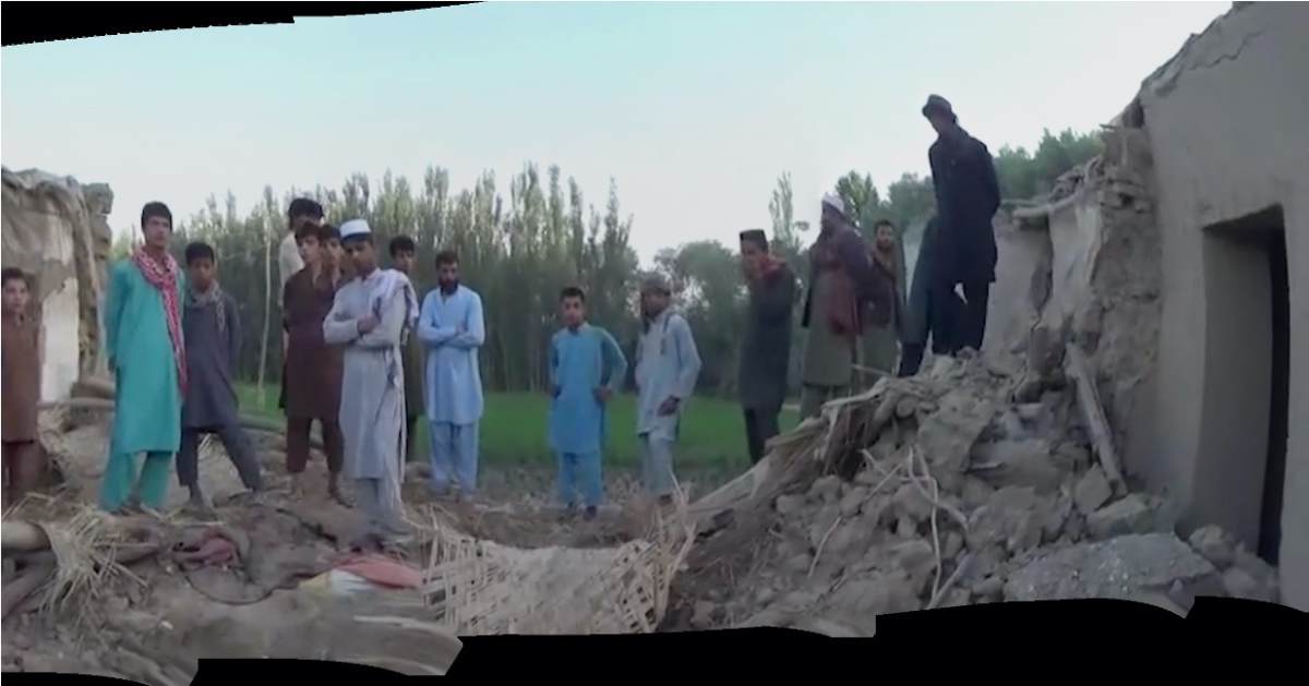
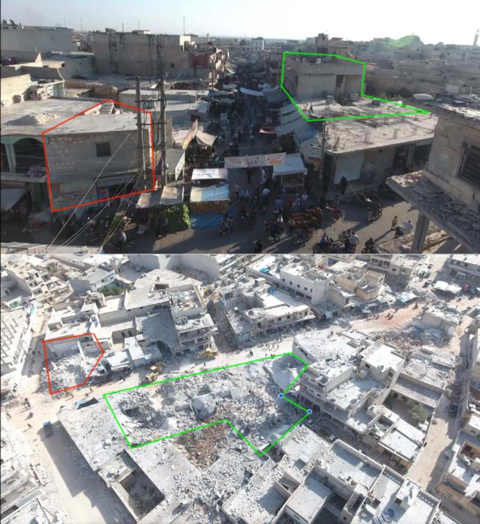
Top: Composite image from the Majed video, Bottom: Satellite imagery taken on 2017/12/01 (courtesy of Google/DigitalGlobe)
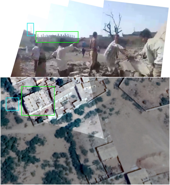
Top: Composite image from Majed video, Bottom: Satellite imagery taken on 2017/12/01 (courtesy of Google/DigitalGlobe)
Building 3 Geolocation
As of the writing of this report, we have not discovered any open source information depicting Building 3. This will become relevant later in the report.
Building 4 Geolocation
Building 4 appeared in several different social media posts, but it could not be matched to any destroyed building found in Abs. A Facebook user named Abou Mohamed Abdel Karim “ابو محمد عبد الكريم” made a post on 2015/05/12 with three images of a damaged building, stating that it was his brother’s house. He also stated that Khalid Yahya’s “خالد يحيى” house had been attacked.
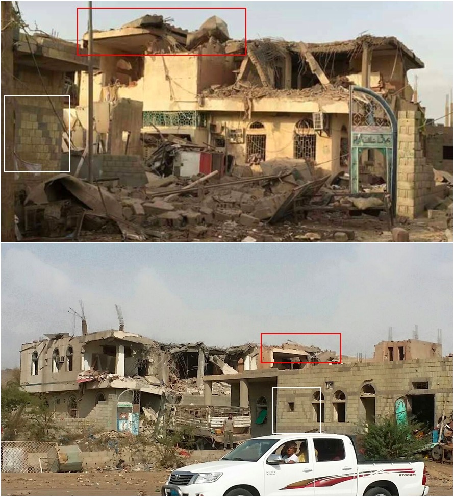
Top: Image from this Facebook post, which re-occurs across other posts. Bottom: Image posted by Mr Karim, allegedly of his brother’s house.
The majority of open sources appear to depict Building 1 or casualties from that location. Two videos depicted Building 2. Due to the lack of open sources depicting Building 3 and Building 4, these locations require further investigation.
(Report continues on next page…)
WHAT HAPPENED?
What was attacked?
There are a large number of reports, whether from international organisations such as HRW, or from social media users in Abs (see DISCOVERY section), that an airstrike took place on the town using multiple munitions. Although virtually all reports mention a prison, a wide range of other buildings are also mentioned, including government offices, a school and a cultural center. In this section we will try and establish what each building was used for.
What was Building 1?
The descriptions of Building 1, where the majority of the open sources appear to originate from, mostly appear to describe it as the prison. However, in the HRW report, the caption of an image taken at this location describes it as the home of Omar Ali Farjain.
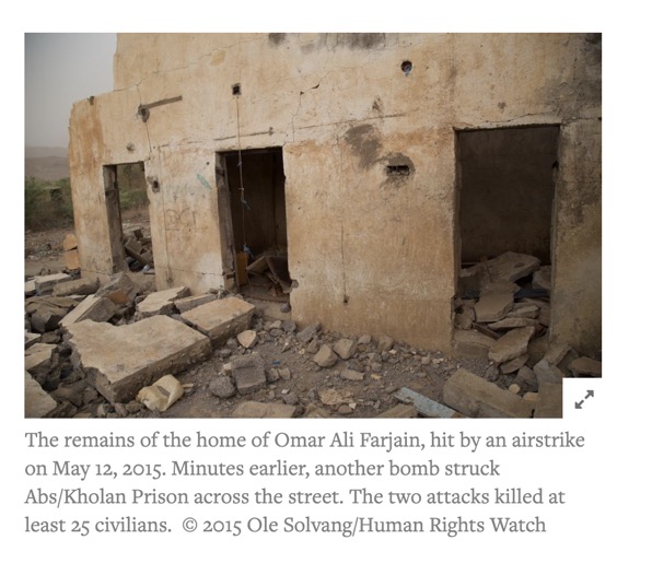
Image of Building 1 in HRW report stating it is the home of Omar Ali Farjain
The HRW report identifies that the home of Mr Farjain was about 50m away from the prison. Approximately 50m to the north-east of Building 1 is a building that has suffered noticeable structural damage during the same period of time as Building 1. It is significantly smaller than Building 1, and it appears the surrounding wall has also been destroyed there.
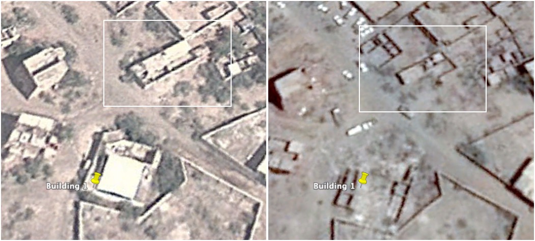
Comparison of the building adjacent to Building 1. Left: satellite imagery taken on 2011/11/12 (due to it being the clearest imagery). Right: satellite imagery taken on 2017/04/09 (both courtesy of Google/Airbus)
This adjacent building was featured in a Yemen Today report one year after this strike took place. Note the Toyota which may be one of the two “military jeeps” that HRW referred to in its report, although it does not appear to have any kind of weapons mount in the truck bed.
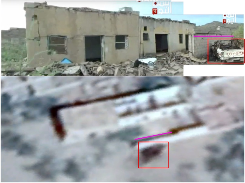
Top: video report from Yemen Today, Bottom: Satellite imagery of build adjacent to Building 1 taken on 2017/12/01 (courtesy of Google/DigitalGlobe)
According to the HRW report the prison also contained a mosque, which was hit and subsequently collapsed. Considering the size and structure of Building 1, it is much more likely that it was the prison containing a mosque than the much smaller adjacent building. Indeed, the layout of the three doorways resemble cells rather than a family home.
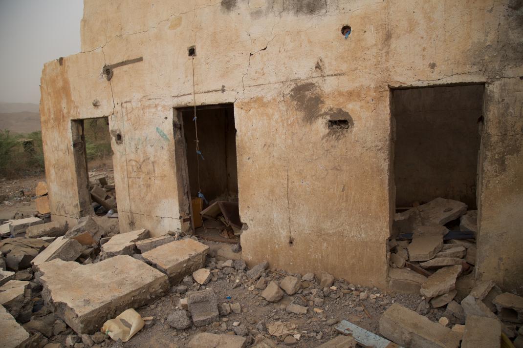
Image of the three doorways from the HRW report. These rooms appear to resemble cells rather than a family home (courtesy of Ole Solvang/Human Rights Watch)
If we considering the following:
– The majority of the user generated content appears to depict Building 1 with reference to a prison.
– HRW stated the prison was large enough to contain a mosque. The adjacent building appears too small to be anything other than a small house.
– Building 1 itself has structures that resemble cells.
Then it appears likely that Building 1 is in fact the prison, and that HRW has mis-labeled the image above as the home of Mr Farjain. It seems much more likely that Mr Farjain’s home is in fact the adjacent building approximately 50m to the north east which suffered structural damage at the same time as Building 1.
At least one media report claimed that there was a Houthi headquarters next to the prison. Some witnesses told HRW that these houses were being used to house the family of military officers, although others denied this. It is not possible to confirm these accusations using open sources.
———-UPDATE AT 2019/04/26 1700 UTC———-
We can now confirm that Building 1 was almost certainly being used as a prison as recently as March 2014. A Yemen Today news report, examining the condition of the jail in Abs, reported from this site. This report was published on Youtube on 2014/03/07. In this report we can see the same distinctive 3 doorways and marks which identify it as Building 1. This makes it very unlikely that this location was the home of Omar Ali Farjain as reported by HRW.
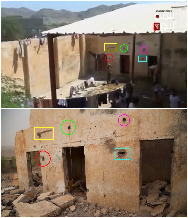
Top: Prison in video report by Yemen Today, published in March 2014. Bottom: Image published by HRW stating it was the home of Omar Ali Farjain
There also exists a video from a local organisation examining this site that was posted in October 2012, indicating this site has been consistently used as a prison.
———-UPDATE ENDS———-
What was Building 2?
Building 2 features in two videos of the attack, but neither video is specific about the purpose of this location.
It should be noted that there are reports of other locations being bombed in addition to the prison. These include:
- Mosnad: “three houses of the Al-Sharafi used as the headquarters of the Houthis in the region.”
- Facebook user: “Citizen’s homes”
- Yemen News Site: “People’s School”
- The media front to confront the Saudi-American aggression: “government complex”
- The Link Yemen: “government compound”
- Al Mersad: “cultural and government complex… the house of Abdu al-Sharafi… and Al-Shaab School”
Repeated media reports appear to indicate that a government complex was also attacked. It should be considered as a possibility that Building 2 was this government complex, although this is not supported by any other open source information.
In the case of Building 2, we appear to have an image of this attack immediately after it took place. This image features in several posts claims to show the attack, and reverse image searches did not reveal that this image had been posted before 2015/05/12.
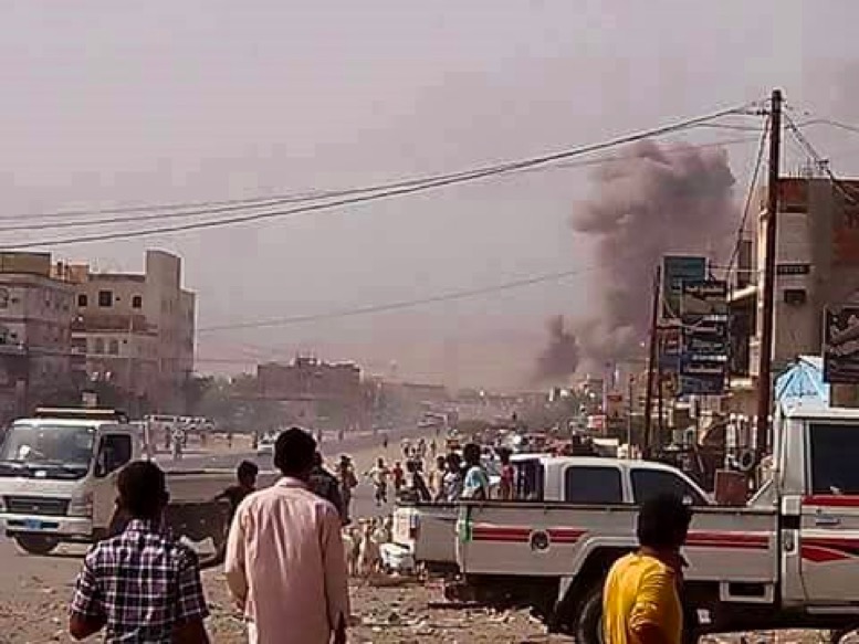
Image of strike, allegedly showing this attack, posted on 2015/05/12 1705 AST.
We can geolocate the building on the left of this image to a location on the main road which runs through Abs, at 15.98708, 43.19342.
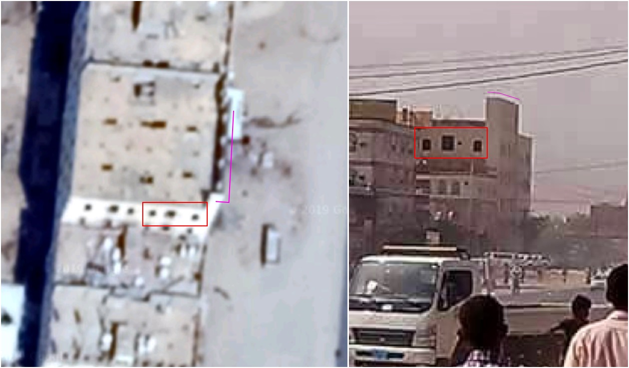
Left: building at 15.98708, 43.19342 (courtesy of Google/DigitalGlobe), Right: cropped image of building in image. Note the uneven distance between the three windows and the unique structure on the roof.
By drawing a line between Building 2 and the likely viewpoint, we can see that the impact cloud direction lines up with the direction in which Building 2 lies.
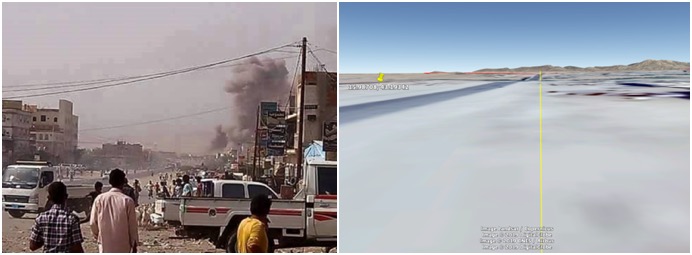
Left: image of airstrike, Right: ground level view from road, with line pointing to Building 2 (courtesy of Google/DigitalGlobe/Airbus/CNES/Copernicus)
What was Building 3?
Building 3 is not featured in any images or videos at all. It is therefore not possible to be sure of its purpose. The HRW report states:
“Since the beginning of the war, several airstrikes in other parts of Abs targeted the military airport, a military compound, and another building off the main road that residents said was being used for military purposes.”
Considering that Building 3 is immediately next to the main road, it could be that this location is Building 3 and was attacked on a different date. This would explain the lack of images or videos of Building 3 posted during the days around 2015/05/12: it was not targeted in this strike.
What is Building 4
Since we have not managed to geolocate Building 4, the only information we have about this location is what was stated by the user who posted the images of it. The user, Abou Mohamed Abdel Karim, stated that:
“This is my brother Rahman’s honorary house in the city of Abs, which was targeted by wanton aggression”
How many locations were hit?
It should be noted that although the HRW report focuses on one area around the prison, JIAT stated it hit two targets, one about 900 meters away from the prison, and another about 1300 meters away from the prison. This implies those two targets were some distance from each other. The analysis above supports this, as it shows there was considerable destruction in the vicinity of the prison at Building 1, as well as at Building 2, which are 470 meters away from each other.
Who was affected?
Images of the casualties of this strike appear to be uniformly men. The majority appear to be adults, but at least four appear to be children. The images are too graphic to post in this report.
Some of the same casualties can be identified across multiple different posts, some of which can be geolocated to Building 1, indicating these are genuine casualties and these images have not simply been “recycled” from other incidents.
None of the casualties appear to be wearing military uniform and no weapons appear to be present in any open sources depicting this event. The only person seen in anything resembling military uniform is the cameraman seen at Building 2 in the Majed video wearing what appeared to be a camouflage waistcoat.
According to the HRW report, the Abs prison was used to house petty criminals. Most of the reported victims were members of the prison population. In addition, children and a passerby were reported to have perished as a result of the incident. HRW also received information that several Saudi prisoners of war were being held at that location but were unable to confirm this.
Casualties
Casualties number ranged from 13 to “over 40” fatalities. The list of casualty reports is below:
Boulevard Yemen: 13 fatalities, 18 wounded
HRW report: 25 fatalities, 18 wounded
Al Mayadeen report: over 30 fatalities
Yemen Satellite Channel: over 40 fatalities
Motabaat report: over 40 fatalities
Legal Support Links: 40 fatalities, 50 wounded
WHEN?
Date
Almost all open sources agree this incident took place on 12 May 2015. The only source that appears to disagree with this date is the Joint Incidents Assessment Team (JIAT), which confirmed two munitions had been dropped on Abs on 2015/05/13. Considering that no strikes were reported on 2015/05/13, and the overwhelming majority of content was posted on 2015/05/12, it seems likely JIAT made some kind of error in their statement.
Time
The earliest report posted to social media about an airstrike in Abs was a Facebook post made on 2015/05/12 at 1537 AST by this account. The post simply stated that there was bombing in the city of Abs “now”.

Facebook post made at 1537 AST stating that bombing was taking place in Abs
At 1538 AST Al Jazeera also stated that there was bombing in the city of Abs

Tweet made by Al Jazeera at 1538 AST mentioning a raid on Abs.
According to a HRW report, two bombs were dropped in an airstrike at approximately 1515 AST: one bomb struck the prison, and another struck a building located approximately 50 meters away from the prison a few minutes later. This is roughly consistent with the posts made on social media.
It should be noted that JIAT stated it hit two targets, one about 900 meters away from the prison, and another about 1300 meters away from the prison, but did not appear to state what the time gap was between these two attacks.
STATEMENTS FROM PARTIES TO THE CONFLICT
The Saudi-led Coalition
The Joint Incidents Assessment Team (JIAT) admitted responsibility for the strikes in Abs in a statement issued on 23 February 2017, claiming that laser-guided bombs were used to destroy two weapon depots used by the Houthis. The press releases in Arabic and English stress that the prison building was neither targeted nor affected by the strike. A second press release on the same day specifically mentioned HRW’s report and stated:
“the Coalition air force has dealt with two targets, both are weaponry depots, by firing a laser guided bomb, at each, on 13 May 2015. These were two Houthi militia’s targets, henceforth, they are military spots, which we took advantage, military speaking, through targeting them.
The team stressed that the building of the prison, neither targeted nor affected, at all, by the air bombing committed by the Coalition air force.”
It should be noted that we have already established that the date given by JIAT, “13 May 2015” is almost certainly incorrect by 24 hours.
The Houthi Government
We could not find an official statement from the Houthi Government
What did JIAT think was the prison?
As JIAT claimed that the two targets it had hit were 900 meters and 1,300 meters from the prison, and that the prison was not affected, we decided to try and discover which building they believed was the prison.
We therefore created two circles with radii of 900 and 1,300 meters and placed them on Building 1 and Building 2, the two locations we know were bombed on this date, in Google Earth.
In the image below, the Building 1 is centered in the red circle with a radius of 1,300 meters, while Building 2 is centered in the yellow circle with a radius of 900 meters:
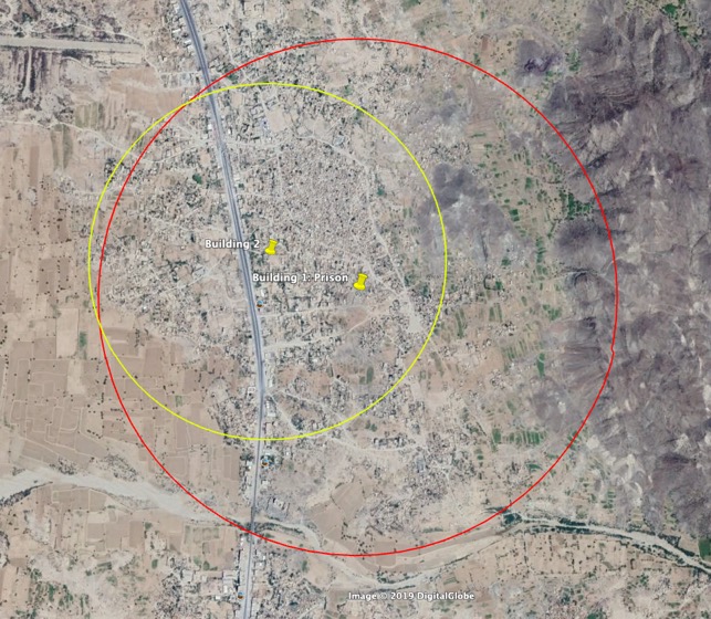
(courtesy of Google/DigitalGlobe)
In the image below, the circles have been switched: Building 1 is in the centre of the red circle with a radius of 900 meters, while Building 2 is in the centre of a yellow circle with a radius of 1,300 meters:
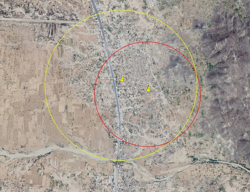
(courtesy of Google/DigitalGlobe)
By checking where the two sets of circles intersect, we were able to narrow down the location of the structure that the JIAT believed to be the Abs prison, to four locations.
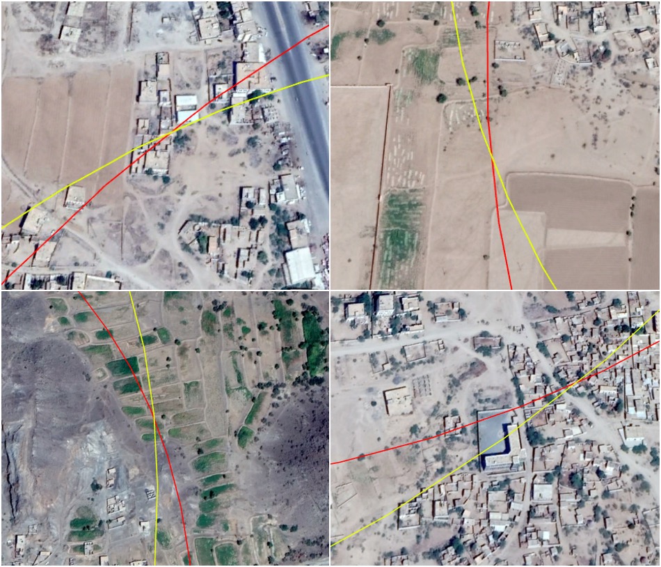
The four locations we identified using this technique (courtesy of Google/DigitalGlobe)
Of these four buildings, only one stands out as appearing to be a structure which might be a prison.
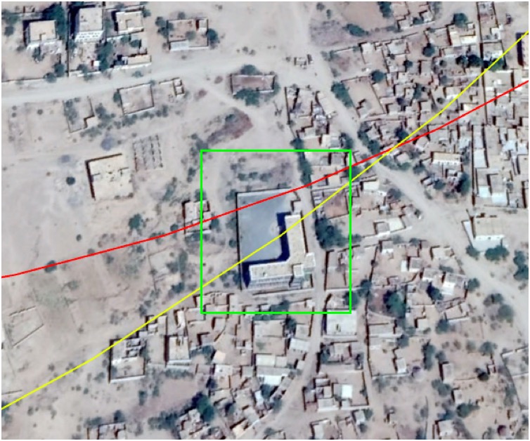
(courtesy of Google/DigitalGlobe)
The walled compound in the green box above is located 900 meters from Building 1, and 1,300 meters from Building 2 at 15.99094, 43.20176. Based on the information provided by the JIAT in its statement, it is possible that this is the location they regard to be the prison. We could not find any information in open sources about the purpose of this building.
WHAT MUNITION WAS USED?
The buildings we identified as being the target of this strike appears to have been almost completely razed, and as such there is no imagery available showing the crater. However, the impact cloud we identified, and the level of damage at Building 1 and Building 2 indicate this was indeed an airstrike.
There were no mention of remnants being found on the scene of the incident. However, a press release from JIAT indicates that the Saudi-led coalition used laser-guided munitions in this strike.
CONCLUSION
From the open sources available, it is clear that on 2015/05/12, starting sometime between 1515 and 1537 AST, two targets were attacked in the town of Abs. With the exception of the JIAT statement, almost all open sources explicitly state that a prison had been bombed in the town of Abs. In this investigation we believe we may have identified the building that JIAT believes to be a prison. Between 13 to 40 people were killed in this strike, including children. Open sources appear to indicate these were civilians, including inmates at a prison. JIAT statements appear to be inconsistent with the open source information available on both the date and the targets of the attack.
