Satellite Imagery Shows Schools and Hospitals Destroyed in Northern Gaza
Thousands of people have begun returning to their abandoned homes in northern Gaza after Israeli forces opened the Netzarim corridor, which separates the northern and southern parts of the territory, on Monday, Jan. 27.
Israel and Hamas reached a ceasefire agreement in Gaza following more than a year of negotiations. The deal was announced on Jan. 15 and went into effect four days later.
“We want to return home … Even though my house is destroyed, I miss my land and my place,” one Palestinian from the Al Shati Refugee Camp told CNN.
But satellite imagery and new images from the ground show that in large parts of North Gaza, there are no homes left to return to, while schools and hospitals which have served as shelters during the conflict have also been hit badly.
A Nov. 29 UN report identified 50 sites for internally displaced people (IDP) in North Gaza. According to an investigation by Bellingcat, more than 80 percent of these sites, mostly schools, have been damaged or destroyed during a three-month-long military operation by the Israel Defense Forces (IDF) that began in October.
Satellite imagery, photos, and videos from the ground show vast destruction in the governorate’s three main cities: Beit Hanoun, Beit Lahia and Jabaliya.
Schools, Hospitals and Camps Destroyed
Schools have historically served as shelters for displaced people during past conflicts in the Gaza Strip. Of the 50 sites in the November UN report, 45 were schools, two were hospitals or health centres, and three were tent camps set up during the summer. These sites are marked on the report’s map with brown lines and the label “IDP Site Extent”.
Scroll and zoom to see damage in North Gaza in each date tab. The first image is from Oct. 14, 2024, after Israeli forces had already started a renewed operation in the area. The second image is from Dec. 2024, after large-scale demolitions took place throughout the area. The latest image is from Jan. 24, 2025, at the onset of the ceasefire, with groups of Palestinians returning to the area visible on the streets. Blue outlines are former IDP sites identified by the UN that we assessed undamaged. Orange outlines are former IDP sites with nearby damage or damage on the grounds. Red outlines are former IDP sites that have been heavily damaged by fire or completely destroyed.
The report didn’t include three major hospitals in North Gaza: Kamal Adwan Hospital, Indonesian Hospital and Al Awda Hospital. While the first two were out of operation in early January due to the IDF’s military operation, they had previously housed patients and IDPs.
Of these 50 sites marked by the UN, only eight appear to not have visible damage based on the Jan. 24 SkySat imagery from Planet Labs. Twenty-eight have been heavily damaged or destroyed, and 14 appear damaged or show signs of destruction in close proximity compared to earlier imagery.
There are indications of extensive fires at several heavily damaged sites. The three tent camps visible in satellite imagery before the October operation have been completely destroyed. The largest one had about 250 tents. After this camp was destroyed, the IDF set up a military position on the site with berms and armoured vehicles visible in satellite imagery.

Before and after satellite imagery from Planet Labs shows the location where a large tent camp for internally displaced people was previously located on the outskirts of Jabaliya in North Gaza. After the IDF began an operation in the area, the tents were cleared and a military position was set up.
When asked about the IDP sites, the IDF said Hamas “systematically violates international law” and uses civilians as human shields.
Torched Schools
At least 14 schools that previously served as IDP sites in the UN report show fire damage in both satellite imagery and on-the-ground photos and videos shared online.
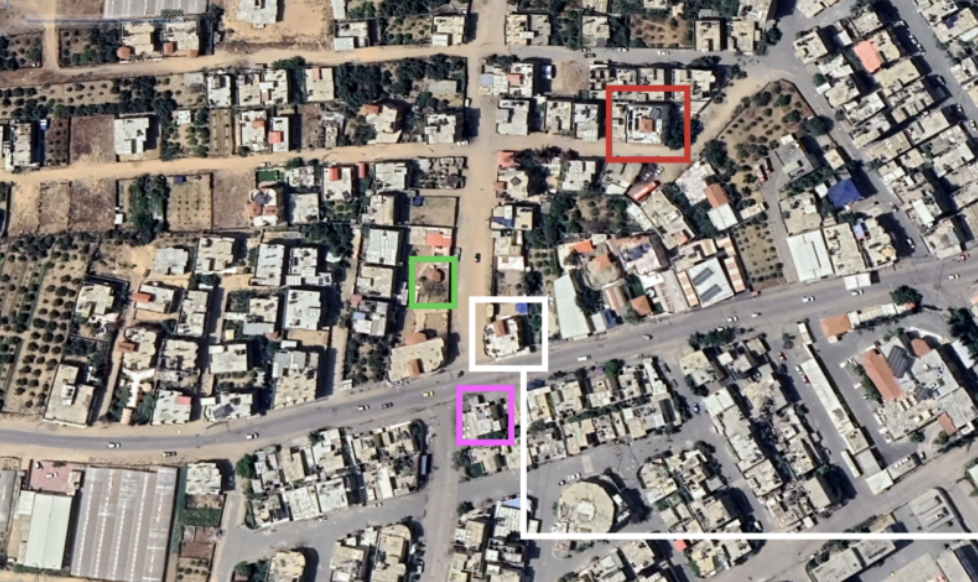
Five of the destroyed schools sit within 500m of the Indonesian Hospital, which has had a heavy IDF presence since October, with fighting taking place nearby. Satellite imagery shows that the Kuwait School, Beit Lahia Preparatory Girls Schools A & B, Al Hertani Secondary School, Hamad Ibn Khalifa Secondary Girls School and Aleppo Schools A & B all appear to have fire damage or have been partly demolished.
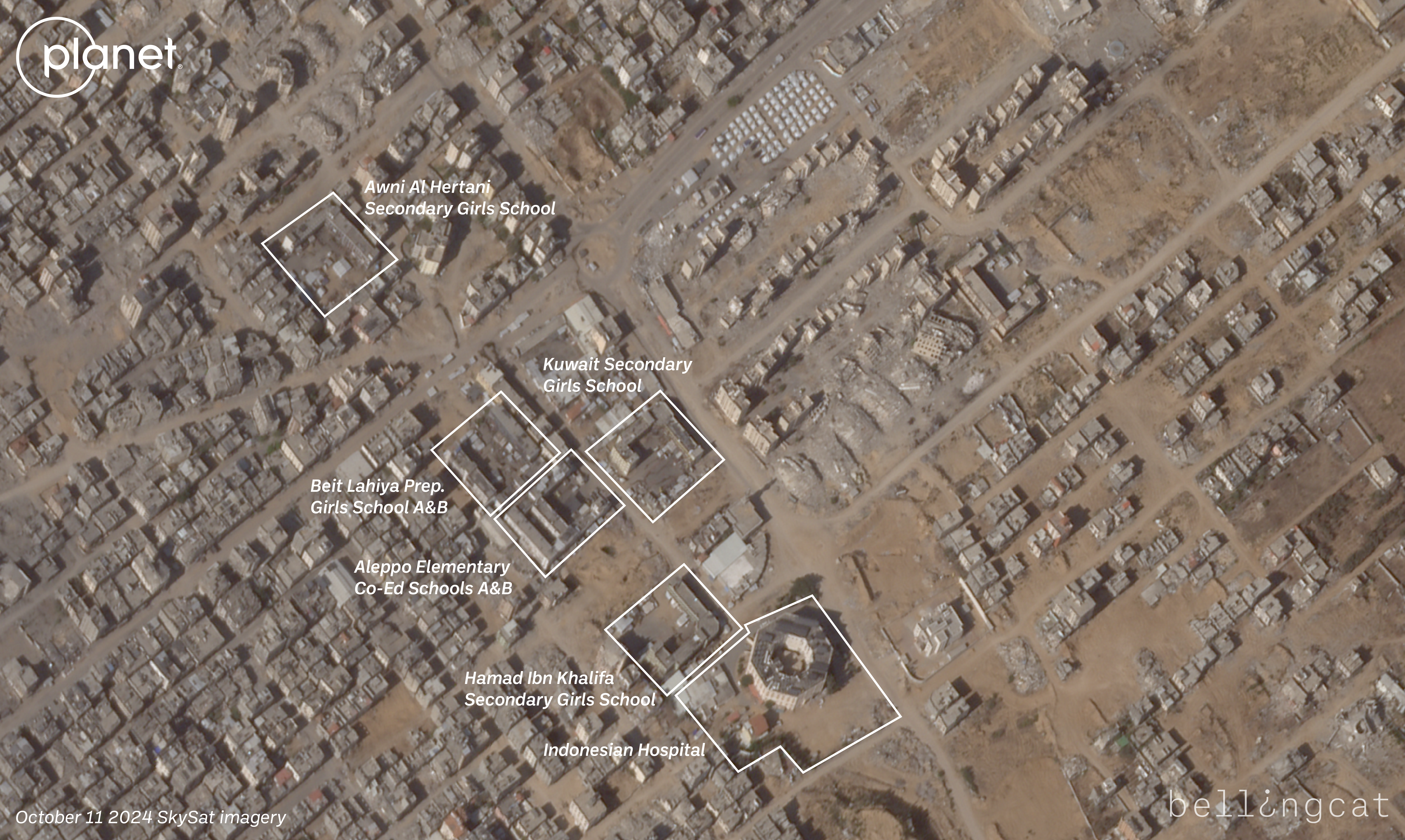
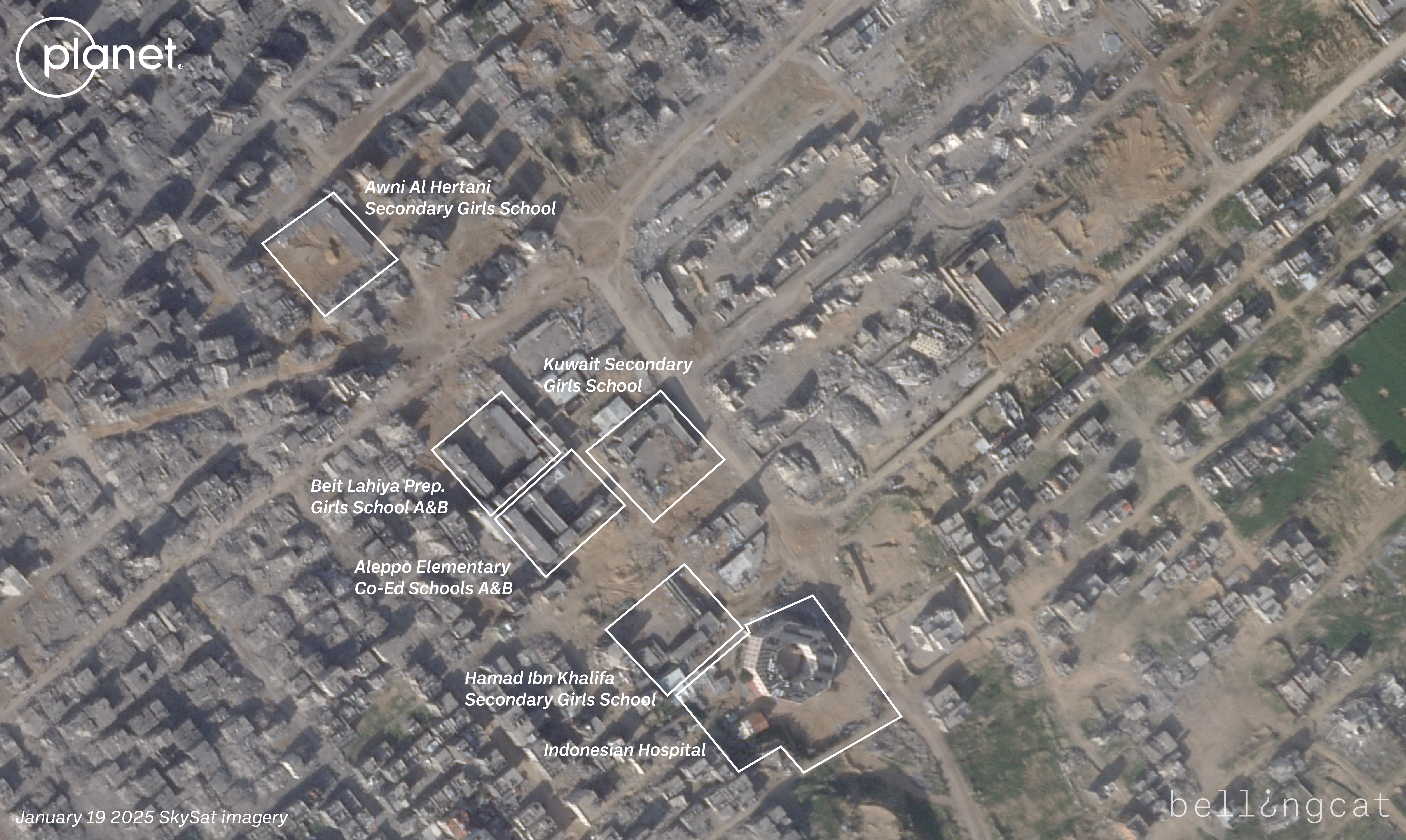
Before and after satellite imagery from Planet Labs shows the area of North Gaza near the Indonesian Hospital. Between October and January, tents for internally displaced people were removed, and multiple schools were either heavily damaged or destroyed.
A drone video shared on Oct. 19 by the IDF’s Arabic spokesperson on X shows the Kuwait School in the background of groups of displaced Palestinians and an IDF armoured vehicle. Another drone video shared four days later, on Oct. 23, by the same account shows the Kuwait School again in the background, this time with heavy fire damage and a large group of displaced Palestinians gathered on the school grounds.
A photo shared on X by Palestinian journalist Younis Tirawi on Oct. 20 shows the Kuwait School on fire, with IDF soldiers posing in front of the burning buildings. Another photo, shared by Tirawi on Oct. 21 and geolocated by volunteers with Geoconfirmed, a community-based geolocating platform, shows Aleppo School B, another nearby school across the street from Kuwait School, on fire.
The Al-Fallujah Secondary School for Girls was visibly burned in an image shared online in mid-November showing dozens of detained Palestinians sitting in front of it, wearing white jumpsuits. SkySat imagery from Planet Labs showed another school on fire on Dec. 9, with a thick column of black smoke billowing from it and red flames visible.

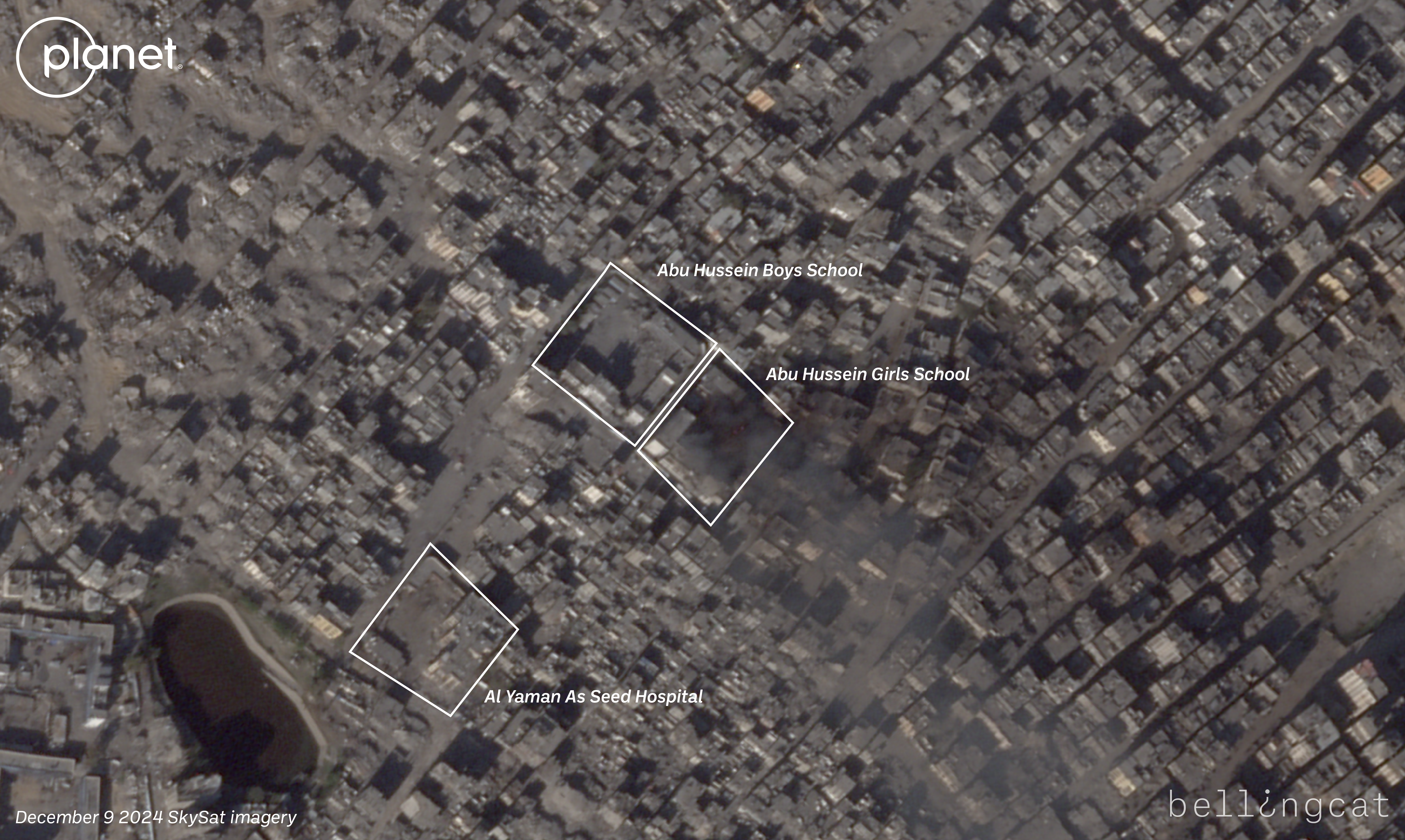
Before and after satellite imagery from Planet Labs shows a part of the Jabaliya refugee camp. In the Dec. 9 imagery, one of two schools in the imagery has a large column of smoke and what appears to be fire on the school grounds.
The IDF did not respond to multiple requests for comment specifically about the burned schools.
December data from the non-profit group Education Cluster found that 100 percent of school buildings in North Gaza had either been directly hit or damaged. The group’s report also revealed that, since Oct. 7 2023, “nearly 88 percent of school buildings in Gaza (496 out of 564) will either need full reconstruction or major rehabilitation work to be functional again.” The difference between the Education Cluster data and Bellingcat’s data is that the former includes events from the beginning of the war, while the latter covers incidents from October.
Mortar Attacks and Tunnel Demolitions
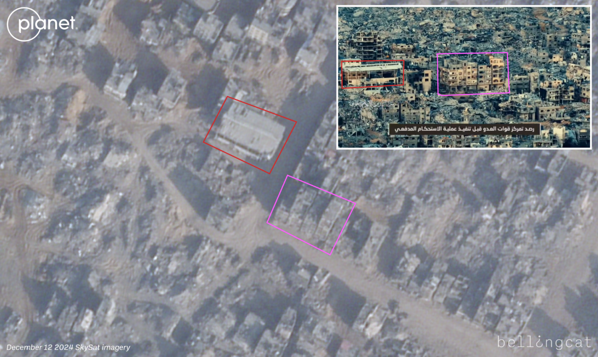
During military operations in North Gaza, both the IDF and militant groups, such as Hamas’ Al-Qassam Brigades and Palestinian Islamic Jihad’s Al-Quds Brigades, have released videos showing activity from both sides.
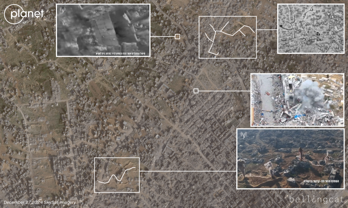
A video from mid-December by the Al-Quds Brigades showed mortar attacks targeting an IDF position in central Jabaliya at 31.5290, 34.4932. Another December video, this time from the Al-Qassam Brigades, showed an Improvised Explosive Device (IED) attack on Israeli soldiers about one kilometre north of the Indonesian Hospital.
The IDF have released numerous updates on its operations in northern Gaza, including multiple videos of tunnel demolitions.
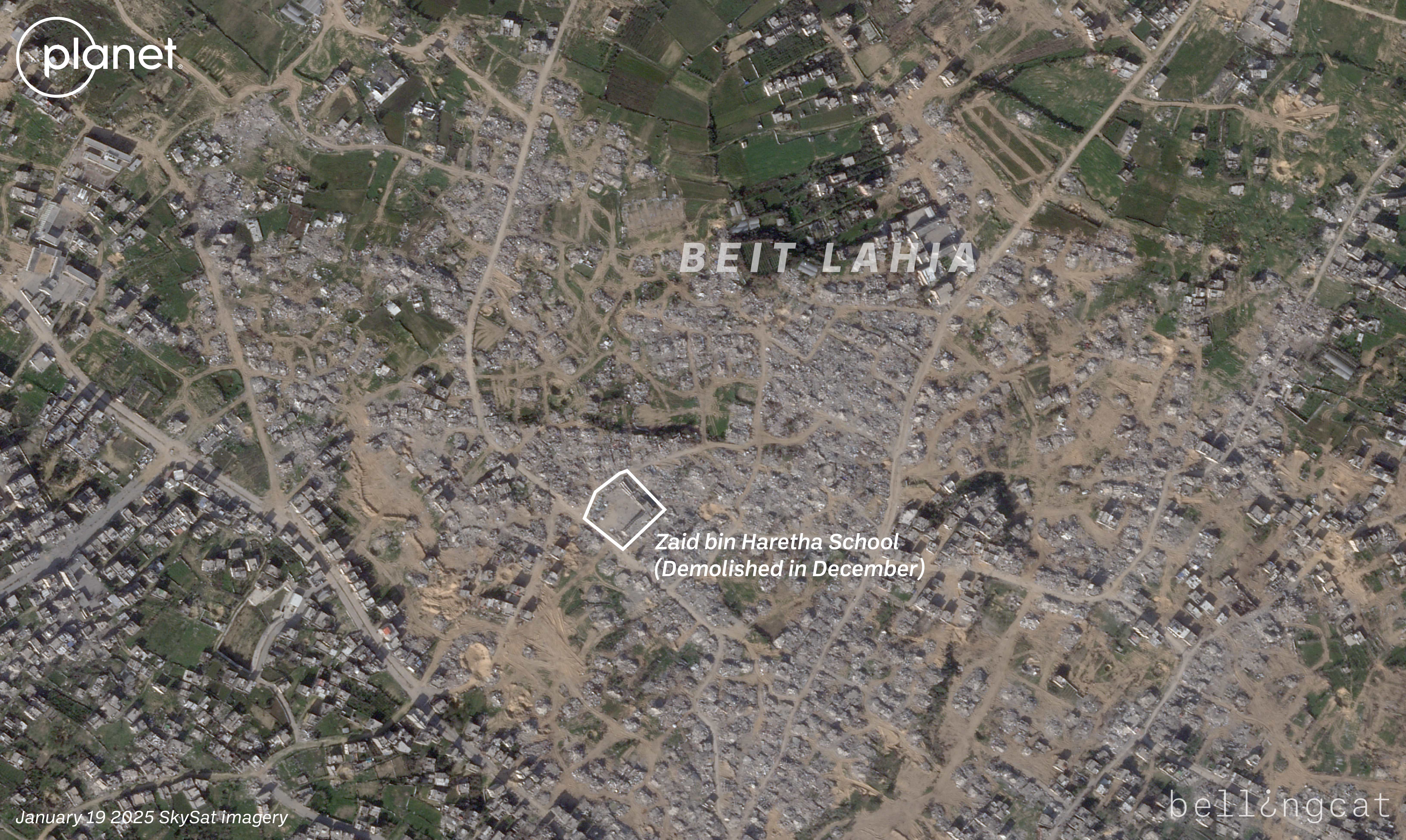
One video released by the IDF in December shows the demolition of the Zaid Ben Haritha Boys Elementary School.
In another video, the IDF claims to have found multiple weapons inside an unnamed school in Jabaliya that was being used by fighters. The interior of the building appears to have suffered extensive fire damage at some point. It’s not clear if this happened before or after the weapons were found inside.
At least three schools examined in this investigation were also targeted by strikes the IDF said were aimed at Hamas or Palestinian Islamic Jihad operatives.
Bellingcat geolocated two tunnel demolition videos released by the IDF, both in the Beit Lahia area.
As much as 10 percent of the total IDF casualties since the beginning of the war have happened in North Gaza during this most recent operation, based on numbers released by the IDF and reporting from the Times of Israel’s military correspondent, Mannie Fabian.
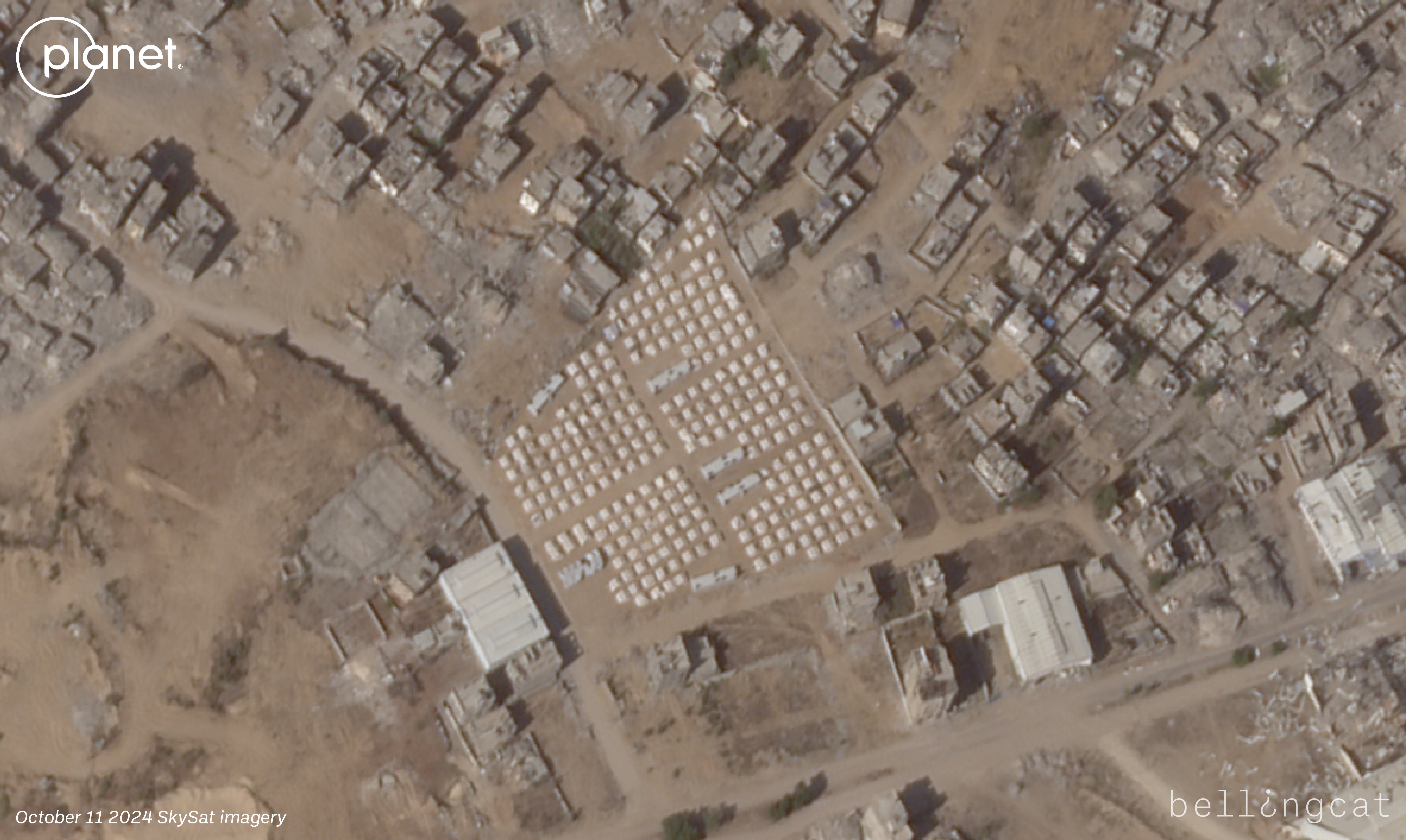
Part of the ceasefire plan is to allow Palestinian civilians to return to their homes in Gaza, including the north. Recent Jan. 19 SkySat imagery from Planet Labs shows Palestinians already returning to areas where the IDF was previously operating, with the imagery capturing people and civilian vehicles in the ruined streets.
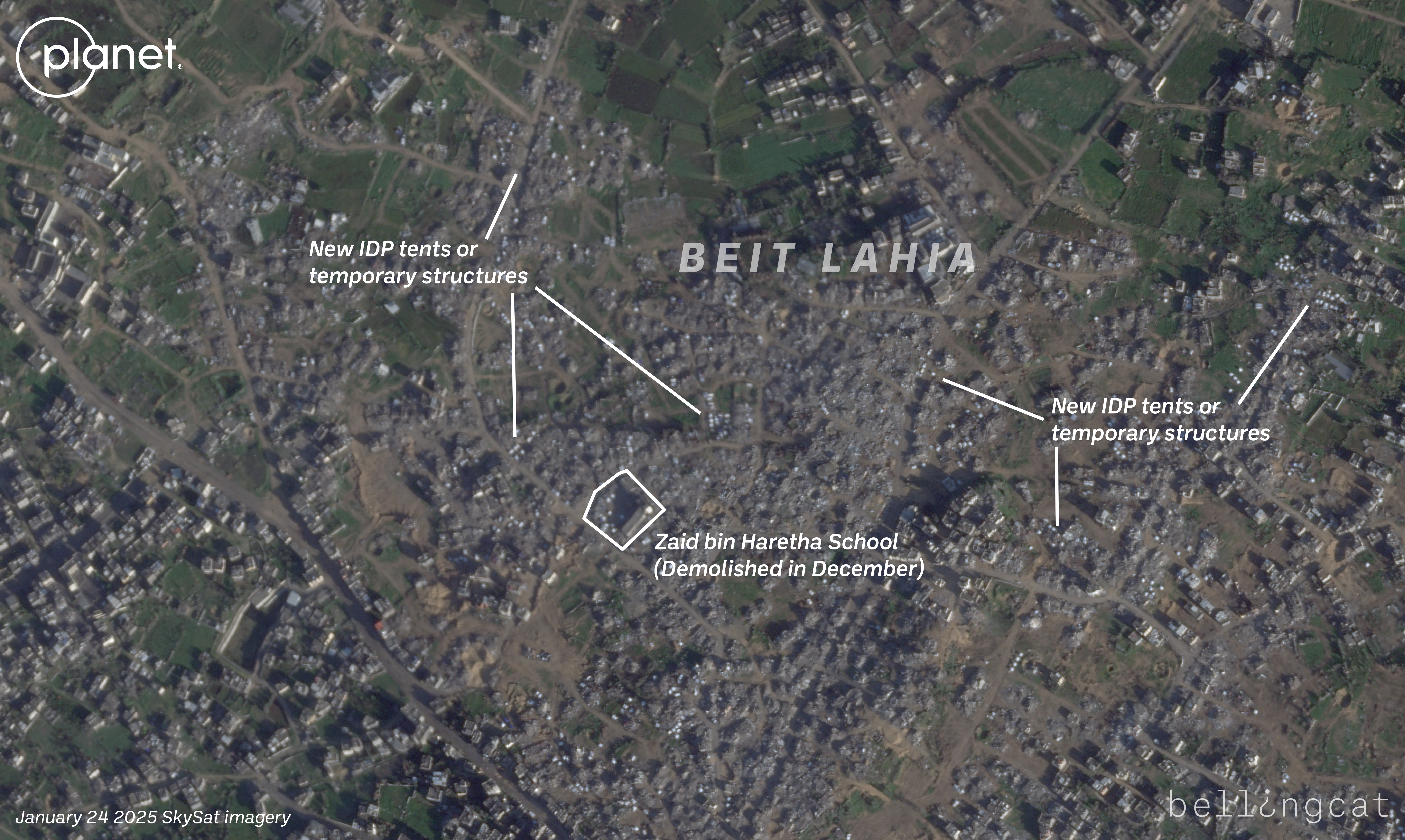
Before and after satellite imagery from Planet Labs shows a heavily destroyed part of Beit Lahia in North Gaza. After the ceasefire was announced and Palestinians were allowed to travel north again, white tents started to appear throughout the rubble and destroyed buildings.
Where homes once stood, people appear to be setting up makeshift shelters – SkySat imagery of the largely destroyed town of Beit Lahia from Jan. 24 showed white tents scattered across the landscape, just days after the ceasefire went into effect.
Bellingcat is a non-profit and the ability to carry out our work is dependent on the kind support of individual donors. If you would like to support our work, you can do so here. You can also subscribe to our Patreon channel here. Subscribe to our Newsletter and follow us on Bluesky here, and Mastodon here.