SpaceX vs Cards Against Humanity: Satellite Imagery Shows Activity on Land at Centre of Legal Case
Elon Musk’s SpaceX has been accused of trespassing on land owned by US game company, Cards Against Humanity, for more than six months as per a lawsuit filed and announced on September 19, 2024. However, satellite imagery shows that the land has been in use for more than 12 months.
At time of writing, SpaceX had not replied to our request for comment. We have no evidence SpaceX knowingly trespassed on Cards Against Humanity’s land. They have not issued any public statement responding to the ongoing lawsuit.
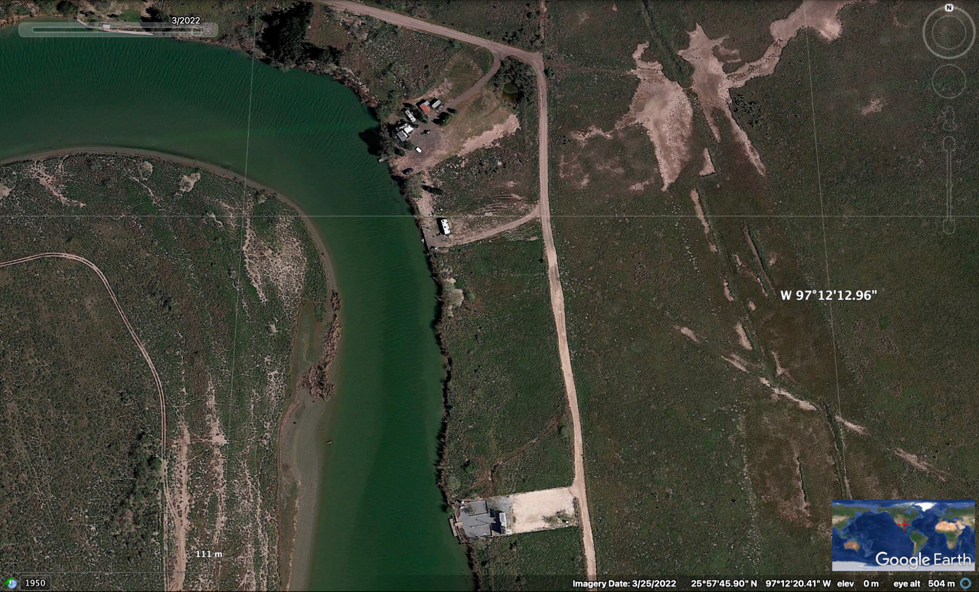
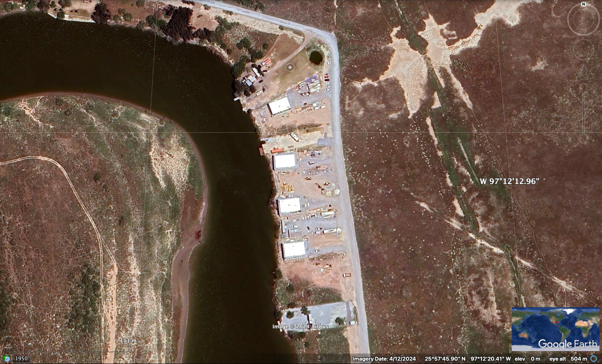
Credit: Google Earth/Airbus. Address: Tarpon Ben, Brownsville, Texas 78521, US
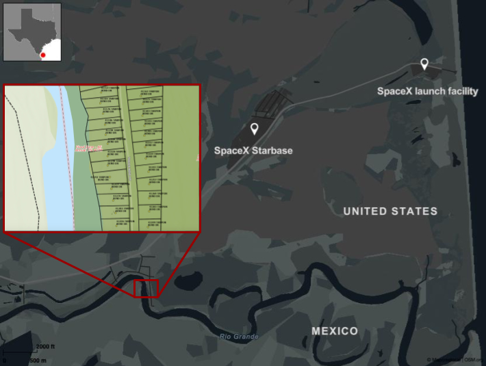
The Cards Against Humanity case revolves around a stretch of land in Cameron County, Texas, where dozens of parcels of land lie adjacent to one another. Running alongside the Rio Grande River, these parcels sit right on the border between the US and Mexico. Several of the plots are owned by Space Exploration Technologies Corp, better known as ‘SpaceX’, but they are interspersed, often wedged between plots belonging to small businesses or individuals.
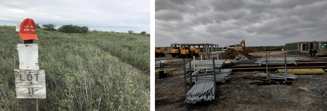
In 2017, Cards Against Humanity purchased parcel number 173555 (formerly known as lot 11) under the name Hole Holding LLC. They bought it in protest of former President Donald Trump’s border wall and with the intention of not developing it, but rather keeping it in its natural state. Cards Against Humanity crowdsourced funding to buy the land, stating that it received 150,000 separate donations of $15 each.
Cards Against Humanity told Bellingcat:
“Our lawsuit is based on SpaceX’s trespass and damage to our property through their extensive use of it for storage of construction materials and vehicles.”
In their lawsuit, they say a fence and a sign stating “No Trespassing” marked the edge of their site. They also state that the work being carried out on this land could make it appear as though their organisation is working with Musk and/or SpaceX’s contractors–something they say is “offensive” and could “be harmful to its reputation with its supporters.”
Timeline of activity
Using the official Cameron County, Texas GIS mapping site, we were able to plot the property lines for all landowners, including SpaceX and Cards Against Humanity. Though the GIS data serves as a useful indicator, it’s important to note the disclaimer on the Cameron County website, which states it represents “only the approximate relative location of property boundaries.”
When viewing satellite imagery from Planet Explorer and Google Earth Pro, we observed construction on the land as early as October 2023, and apparent activity as early as June 2023, earlier than the date referenced in the Cards Against Humanity lawsuit.
Cards Against Humanity told Bellingcat that at the time of writing their petition, “SpaceX’s violation had been happening for over six months.” They acknowledged it would now amount to “about a year.”
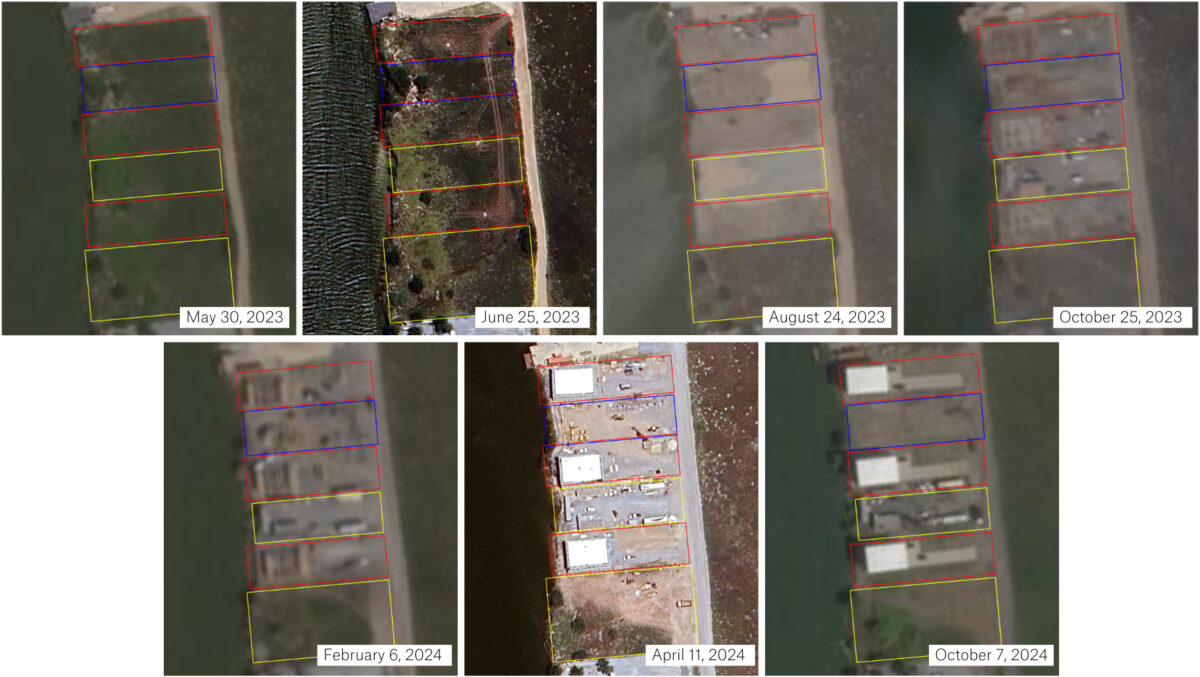
We roughly annotated plots belonging to SpaceX (red) and Card Cards Against Humanity (blue) in the image below. These are estimations and not exact property lines, as per the Cameron County disclaimer about the data listed on its site. SpaceX also owns another plot closeby, as will be detailed later.
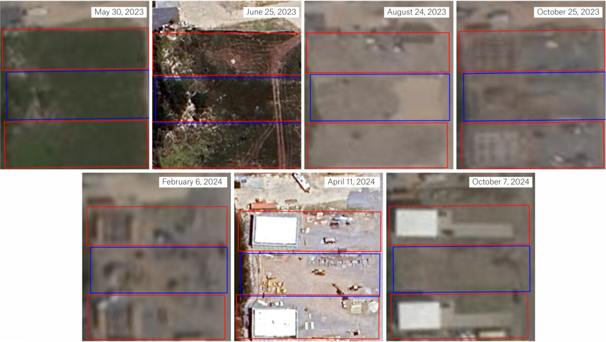
The land appears untouched at the end of May 2023, but less than a month later, tyre tracks are visible across several lots. By August 2023, almost all of the vegetation has been cleared. By April 2024, several structures have been erected on plots belonging to SpaceX. These buildings are still visible in the most recent satellite imagery from October 2024.
SpaceX did not respond to questions about whether its activities and/or its contractors were responsible for the vehicle marks visible in June 2023 satellite imagery or other questions relating to activity on the plots of land.
SpaceX was issued with an official address for lot 10 on June 17, 2023, adjacent to Cards Against Humanity’s plot, lot 11. This was detailed in an undated image of a public notice included in the Cards Against Humanity lawsuit.
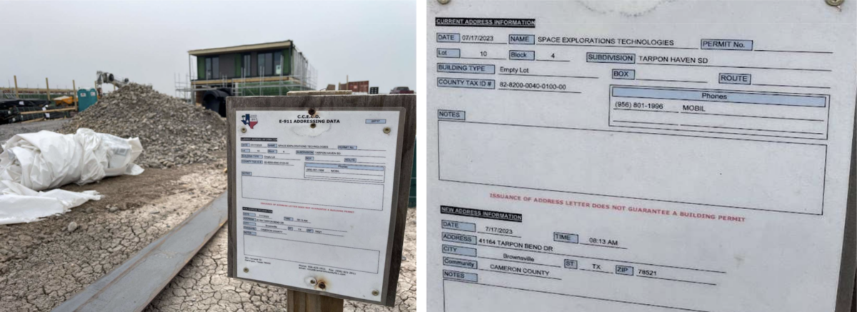
It must be noted that the image was likely taken sometime after June 2023, as the construction of the buildings in the background appears more advanced than what is visible in the satellite imagery at this time.
However, as the image montage above shows, activity was first detected at the site around June 2023, aligning with the June 17 date. The first signs of the structures seen in the images from the lawsuit were captured in satellite imagery from October 2023.
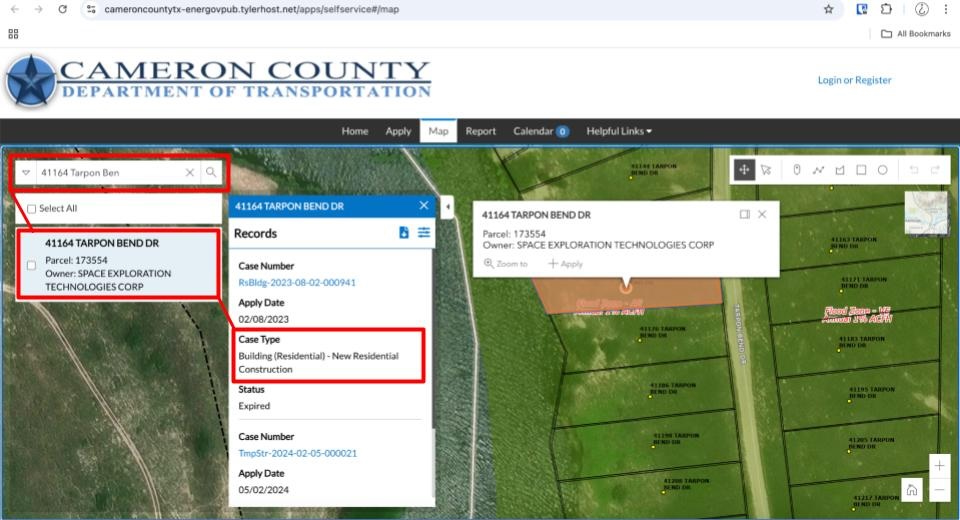
A search of the Cameron County Department of Transportation database shows three residential construction permits for SpaceX, approved by the City and issued in September 2023. There were also three temporary structure permits for the same parcels, issued in February 2024. The dates these permits were issued align with when satellite data first shows the construction of the buildings.
Analysis suggests these buildings have not encroached on any land other than those belonging to SpaceX. However, given the disclaimer by Cameron County’s GIS mapping service that the data represents only an “approximate relative location of property boundaries,” an on-the-ground survey would be needed for complete accuracy.
Another interesting observation from the satellite imagery is that it appears it is not just land owned by Cards Against Humanity that has been affected. Activity is also visible during the same time period on three other neighbouring parcels.
As can be seen in the below image, where the plots of two other independent landowners have been highlighted in yellow (with SpaceX in red and Cards Against Humanity in blue), work seems to have impacted these sites too over the same time period. We have no evidence SpaceX or its contractors knowingly trespassed on these parcels of land.
Bellingcat attempted to contact the individuals listed on the Cameron County website as the owners of these plots to ask whether the activity seen in the satellite images was related to them or if anyone had contacted them regarding the use of their land. Bellingcat also asked if they had sold the land to SpaceX.
One declined to speak with us, while the other, we discovered, was deceased. When speaking with their family, they said that they were unaware of any activity on the land. They said they had recently agreed to sell the plot to SpaceX. For privacy reasons, they asked not to be named.
At time of writing, the Cameron County website still listed the deceased individual as the parcel’s registered owner. Cameron County’s Appraisal Department told Bellingcat via email that as it is not a legal requirement for their department to be notified when a transfer of ownership takes place, they cannot guarantee that the data on their website is up to date.
Bellingcat sought comment from SpaceX regarding the details in this story but did not receive a response before publication.
Bellingcat is a non-profit and the ability to carry out our work is dependent on the kind support of individual donors. If you would like to support our work, you can do so here. You can also subscribe to our Patreon channel here. Subscribe to our Newsletter and follow us on Twitter here and Mastodon here.