Satellite Imagery Shows Vast Destruction in Rafah
“Please, can you help me obtain a recent photo of my residential area in Tall As Sultan to check on our homes?”
The question was sent via X, the platform previously known as Twitter, and detailed an area on the outskirts of the city of Rafah in southern Gaza. Such requests, from people who say they’ve been forced to flee their homes, have become common for many open source researchers documenting Israel’s 10-month-old invasion.
Verifying the identity of those sending such messages can be difficult. Israel has prevented foreign press from entering Gaza, which has suffered extensively during the air and ground incursion that followed the October 7 Hamas attacks. Many Gazans who reach out, meanwhile, take precautions not to reveal their real identity – especially if they voice frustrations about Hamas.
On this occasion, the broader issue was something Bellingcat had already been monitoring for several weeks.
Israel Defense Forces (IDF) invaded Rafah in May this year in order to establish control over the Gaza-Egypt border – an eight-mile-long strip of land referred to as the “Philadelphi Corridor”. Recent imagery provided by Planet Labs PBC showed a large amount of destruction not only along the corridor but in neighbourhoods two kilometres from the border such as eastern Tall As Sultan.
Before and after satellite imagery from Planet Labs shows the eastern residential neighbourhood. After the IDF began an operation in the area, the majority of buildings in the neighbourhood were destroyed.
Using OpenStreetMap building data, Bellingcat found that out of the roughly 670 buildings in an eastern neighbourhood of Tall As Sultan, only 224 remained standing.
Based on historical imagery from Google Earth, it is possible to see that the largely residential area was built more than a decade ago. But most buildings were demolished between July 18 and August 4 2024, after the IDF arrived. The house identified by the individual who reached out via X was one of those that had been demolished.
In May, U.S. President Joe Biden set a “red line” for Israel during an interview with CNN. If the Israel Defense Forces went into Rafah’s population centres, such as Tall As Sultan, his administration was going to start limiting what weapons the U.S. would provide Israel. When asked about the red line days later, U.S. Secretary of State Antony Blinken clarified that the president specifically referred to a “major military operation” in Rafah.
The Biden administration’s position has not changed since then. Bellingcat asked the US State Department whether the IDF had crossed any red lines but had not received an answer by the time of publication.
Yet further satellite imagery from Planet Labs shows how the landscape of other parts of Rafah and southern Gaza, beyond just Tall As Sultan, have changed dramatically since May.
Plans To Expand the Philadelphi Corridor
The IDF announced they had “operational control” over the Philadelphi Corridor in late May. Recent satellite imagery shows they are maintaining a military presence along the corridor.
The Planet Labs imagery shows vast swaths of Rafah have been damaged or destroyed since the IDF began its ground operation in the city. Bellingcat has annotated before and after imagery of a section of Rafah stretching from the border crossing with Egypt to the coast.
Scroll and zoom to see damage along the Philadelphi Corridor in each of the date tabs. The first image is from November 23, 2023, after Israeli forces had already started hitting Rafah with airstrikes. The second one is from April 2024, before the major ground operation in May began. The latest image is from August 22, 2024.
Using a damage tracking tool developed by Bellingcat contributor Ollie Ballinger, Bellingcat estimates that almost 8,500 buildings have been damaged or destroyed in just this region of southern Gaza alone from the start of the war in October last year until July of this year. The number is likely higher, given the destruction visible in the more recent August imagery from Planet Labs.
Data from the Decentralized Damage Mapping Group, which uses Sentinel-1 radar data to determine damage throughout the Gaza Strip, shows that almost 44 percent of all buildings in the Rafah governorate in southern Gaza have been damaged or destroyed.
Reporting from the Times of Israel’s military correspondent suggests the IDF plans to expand the Philadelphi Corridor as deep as 800 metres into southern Gaza, something that would result in the destruction of even more homes and most of the city of Rafah.
“The plan to expand the Philadelphi Route stems from the need to improve the infrastructure for vehicle and armoured vehicle travel. […] The aim of expanding the route is to reduce the number of these accidents and provide drivers with safer access to the area. This action will improve the IDF’s operational capabilities and protect the lives of both soldiers and civilians,” the IDF told Bellingcat.
Satellite imagery shows that the Israel Defense Forces demolished entire city blocks along this route, including the Brazil Refugee Camp and the Al Salam Neighborhood. This is something that has happened in other parts of the Gaza Strip in the past.
Before and after satellite imagery from Planet Labs shows the Brazil Refugee Camp in southern Rafah city. A large portion of the neighbourhood, especially the part closer to the border with Egypt, has been demolished by the IDF.
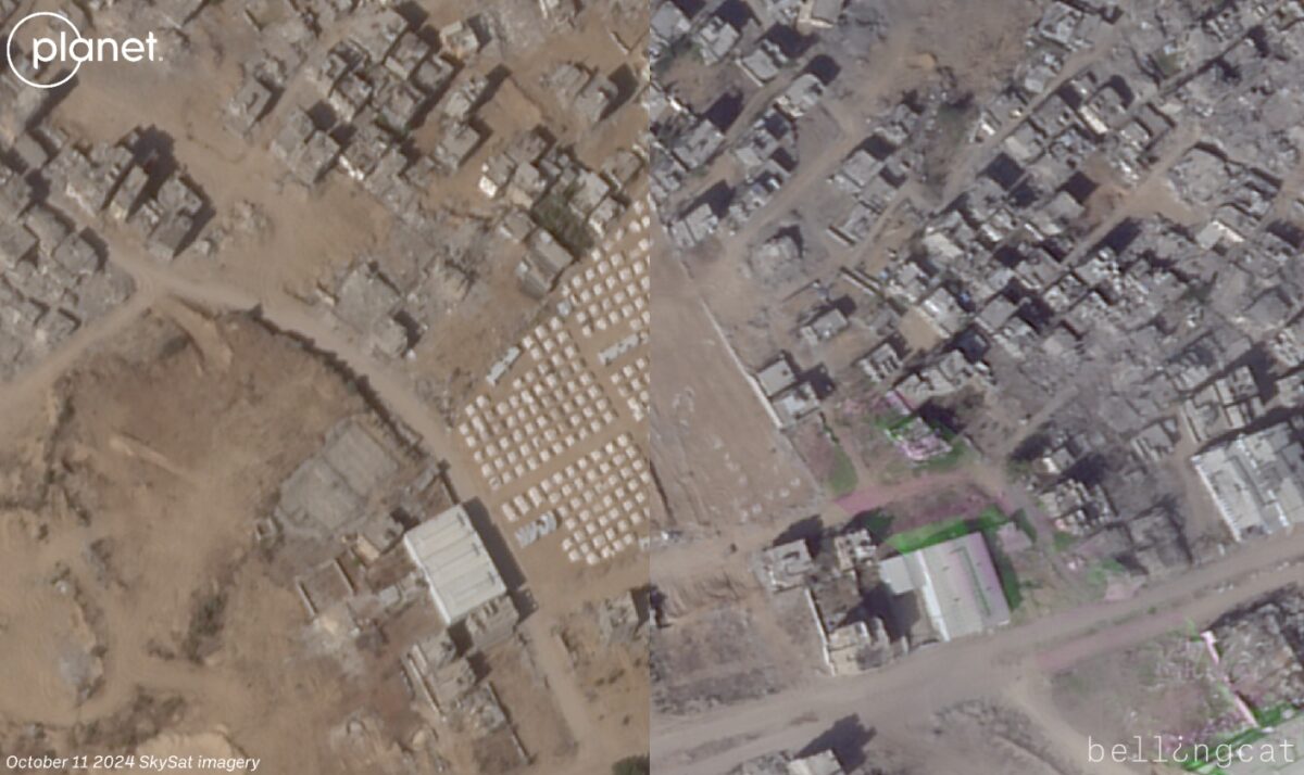
Before and after satellite imagery from Planet Labs shows the Al Salam Neighborhood in southern Rafah city near the Eastern Rafah Cemetery. The vast majority of buildings in and around the neighbourhood have been destroyed by the IDF.
Al Qarya As Suwayda, or the Swedish Village, sits on the coast next to the border with Egypt. The small community of about 1,300 people was largely neglected before the war and faced numerous problems ranging from lack of basic services to coastal erosion.
Satellite imagery from Planet Labs shows that between June 5 and June 7, most of the village was demolished by the IDF. More recent imagery from August 22 shows what appears to be a newly-constructed gravel staging area and road connecting to the coast built by the IDF.
Before and after satellite imagery from Planet Labs shows Al Qarya as Suwayda, or the Swedish Village after it was destroyed by the IDF in June. The more recent imagery from August shows a new gravel staging area and a small road connecting to the coast have been constructed.
“Large portions of neighbourhoods in the Gaza Strip were converted into combat zones as a result of Hamas’ use of the areas for terror purposes,” the IDF told Bellingcat. In a video released in June, they also claimed that Hamas fighters used parts of the village.
There are areas in the Philadelphi Corridor that the IDF have used as staging grounds for their forces during the operation in Rafah. A video from Hamas’ military wing, the Al Qassam Brigades, in July, showed fighters targeting IDF vehicles located at a group of buildings near Tal Zoroub, a hill that sits along the Gaza-Egypt border.
Satellite imagery from Planet Labs shows that the buildings used for that staging ground were demolished between July 6 and July 17. Based on what is visible in the Hamas drone video, it is more likely that their video was filmed in June rather than July.
Before and after satellite imagery from Planet Labs shows a cluster of homes in Rafah at 31.300891, 34.239935 apparently being used by the IDF as a staging area. Video from Hamas’ Al Qassam Brigades showed the buildings being targeted in an attack and more recent imagery shows that the buildings have since been demolished.
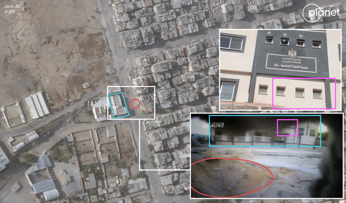
Another Hamas video showing an IED attack against an IDF vehicle can be geolocated about one kilometre from this staging area to 31.3087185, 34.2365347. The large crater seen in the Hamas video is visible in Planet Labs imagery from June 23.
Yet analysis shows that it’s not just areas along the Philadelphi Corridor that are seeing heavy damage. Recent imagery shows destruction throughout the Rafah governorate in areas beyond the 800-metre buffer zone – including in Tall As Sultan.
A video found on Instagram and shared by Younis Tirawi, a Palestinian open source researcher, showed IDF soldiers demolishing part of a water well facility in an area near the eastern part of Tall As Sultan. While the large water tank appears to still be standing, the most recent satellite imagery shows the smaller buildings in the facility were destroyed in the demolition.
Before and after satellite imagery from Planet Labs shows the damage at the Canada Well located at 31.311417, 34.247442 in Rafah’s Tell As Sultan neighbourhood after a video shared by an IDF soldier on Instagram showed part of the facility being destroyed in a planned demolition.
The IDF told Bellingcat the circumstances of the video and demolition were under review and that it “acts to address exceptional incidents that deviate from the orders and expected values of IDF soldiers.”
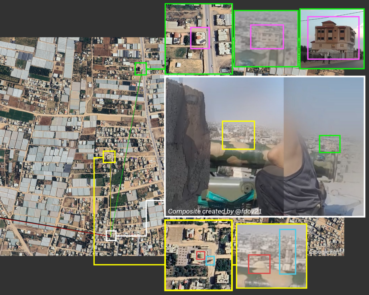
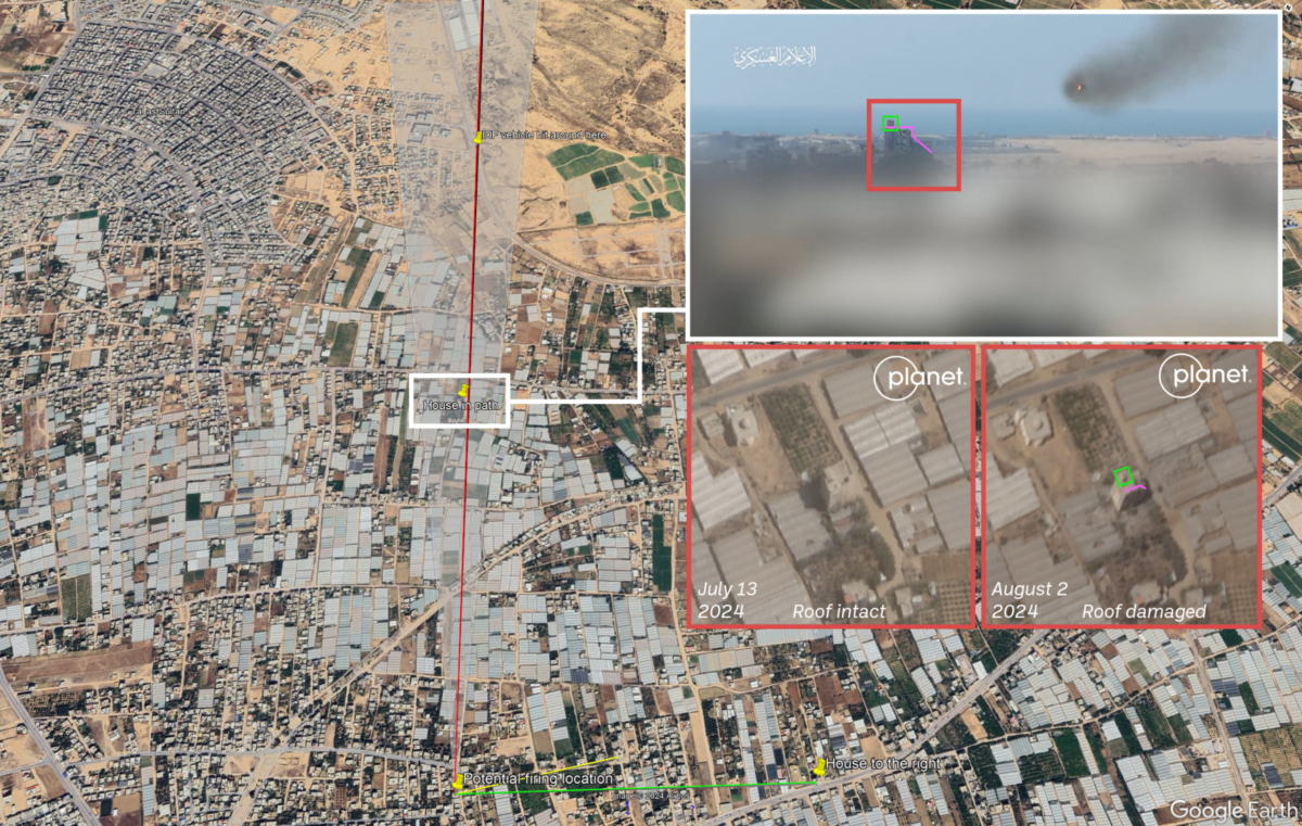
Hamas has shared a video showing attacks against IDF troops in this area as well. One video, shared on August 1, shows Al Qassam Brigade fighters using a Chinese HJ-8L anti-tank guided missile system to target IDF vehicles near 31.3129664, 34.2525086 — an area just south of the now-abandoned UNRWA logistics facility that housed thousands of internally displaced people earlier in the war. The facility, now stripped of its roofing, is visible in the background of the video recorded by the Al Qassam Brigade fighters.
Bellingcat was able to geolocate the location from where the missile was fired — a residential tower more than two kilometres from where the IDF positions were. Online open source analyst fdov, who has monitored the conflicts in Ukraine and Gaza, shared a video they found online that shows a street view of one of the buildings in the background of the Al Qassam Brigade video. Planet Labs imagery shows that this same tower was destroyed on August 2.
There’s No Safe Place To Go
This isn’t the first time Israel has conducted mass demolition in Rafah. Twenty years ago, before the Israeli disengagement from the Gaza Strip, Human Rights Watch documented extensive IDF demolitions in Rafah along the border. In its report, Human Rights Watch said that two-thirds of the Palestinian homes demolished in the Gaza Strip in the previous four years were in Rafah, where 16,000 people lost their homes.
Fred Abrahams, currently an adjunct at Bard College in Berlin, researched and wrote the 2004 report. “Unlawful destruction in Gaza goes back many years, so the policy has roots. The key under international law is whether destroying a structure brings a specific military advantage. We repeatedly showed that the systematic destruction over a large area failed to meet that test,” he told Bellingcat, commenting on recent destructions in Rafah.
Bellingcat asked IDF for evidence linking demolished buildings in and around the Philadelphi Corridor to “terror purposes”. The IDF replied with a press statement showcasing a three metre high tunnel that was found in the area. In a more recent press statement, they said, “Soldiers destroyed approximately 50 Hamas underground tunnel routes” between August 8 and August 15.
Nadia Hardman, the Refugee and Migrant Rights Researcher at Human Rights Watch told Bellingcat that the Israeli military should not be taking actions that render return impossible.
“Most Gaza residents have fled – many multiple times – pursuant to Israeli orders, in search of safety. But there’s no safe place to go and no safe way to get there. International humanitarian law prohibits the forced displacement of civilians except temporarily when required for their security or imperative military reasons,” she told Bellingcat.
“We are seeing mounting evidence that the Israeli authorities may be committing the war crime of forced displacement by turning neighbourhoods into rubble and destroying or damaging the majority of homes and basic infrastructure in Gaza, making large parts of the Strip unliveable for years to come,” Hardman said.
Logan Williams contributed research to this piece.
OpenStreetMap is open data compiled from community contributions, and is available under the Open Database License (ODbL).
Bellingcat is a non-profit and the ability to carry out our work is dependent on the kind support of individual donors. If you would like to support our work, you can do so here. You can also subscribe to our Patreon channel here. Subscribe to our Newsletter and follow us on Twitter here and Mastodon here.