Chernobyl Burning? Not Great, Not Terrible
Forest fires rapidly approached the radioactive remnants of Chernobyl’s nuclear reactors last week, raising alarm bells in national and international media over possible consequences. Reactor No. 4 — which melted down on April 26, 1986, causing the worst nuclear disaster in human history — is located near the city of Pripyat, north-west of the country’s capital Kyiv. Early warnings went out in the beginning of April as forest fires increased in the region.
A lot of #openburning & surface PM2.5 across Eastern Europe in #Copernicus Atmosphere Monitoring Service products visualized by @windyforecast https://t.co/thobQcNVWN. GFAS daily total FRP for Belarus & Ukraine have been well above 2003-2019 average for many days recently. pic.twitter.com/y4yqduQLub
— Mark Parrington (@m_parrington) April 10, 2020
Soon after, the fires spread closer to Chernobyl:
? #Wildfire? about 50 kilometers West of #Pripyat and the Chernobyl Nuclear Power Plant #KyivOblast #Ukraine?? 5 April 2020 Enh. nat, col. + IR overlay #Copernicus #Sentinel-2?️ Full-size ➡️ https://t.co/zLlDNArDOa #RemoteSensing #scicomm #OpenData Image is about 60 km wide pic.twitter.com/6LF5llx9I7
— Pierre Markuse (@Pierre_Markuse) April 8, 2020
On social media, footage showing the burning forest meanwhile spread:
Вид з автобуса біля ЧАЕС. Прямо зараз
?В'ячеслав Дзигман pic.twitter.com/4a1KmFJqXa— Конопляний Джмелик (@dmitrosel007) April 13, 2020
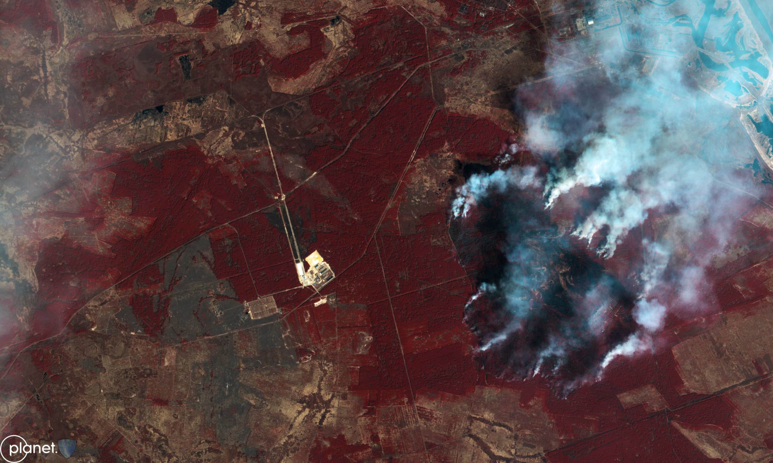
The fires were quickly developing, coming in from the south-east of the sarcophagus, as is clearly visible on the Planet Labs imagery, processed by @AuroraIntel
Planet Labs, April 8, 2020, False Colour rendering
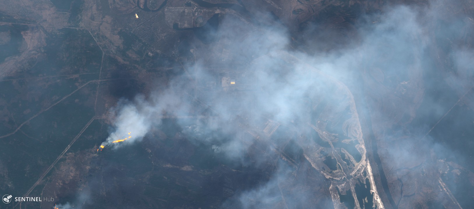
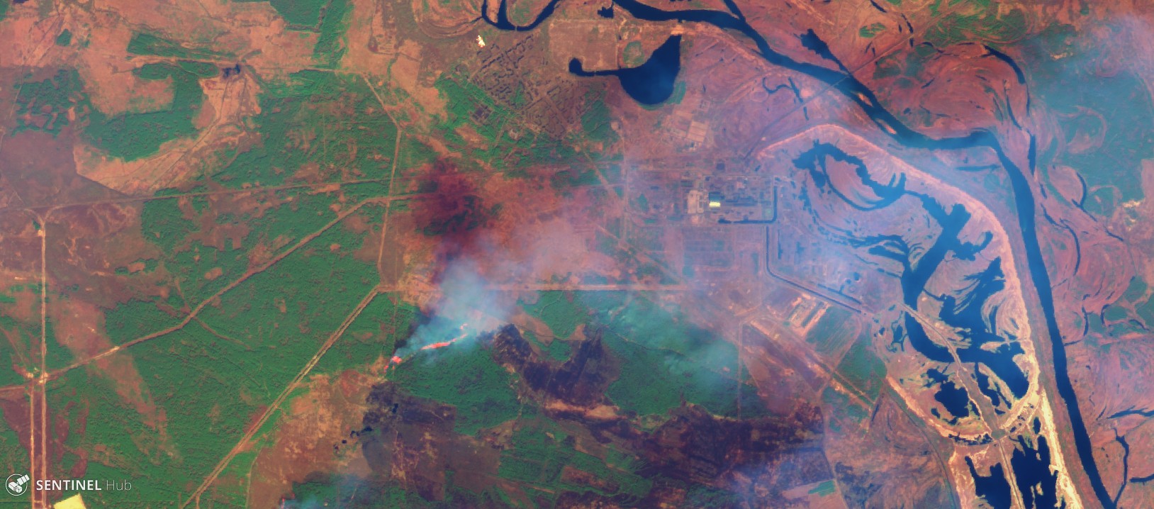
Satellite imagery from both Planet Labs and ESA’s Sentinel-2, obtained via Sentinel Hub, showed the fires spreading further in the following days.
Forest fire south-west of the former nuclear reactor, April 12, 2020 with Pierre Markuse’s Wildfire script
Same image as above, April 12, 2020 with Agriculture Index
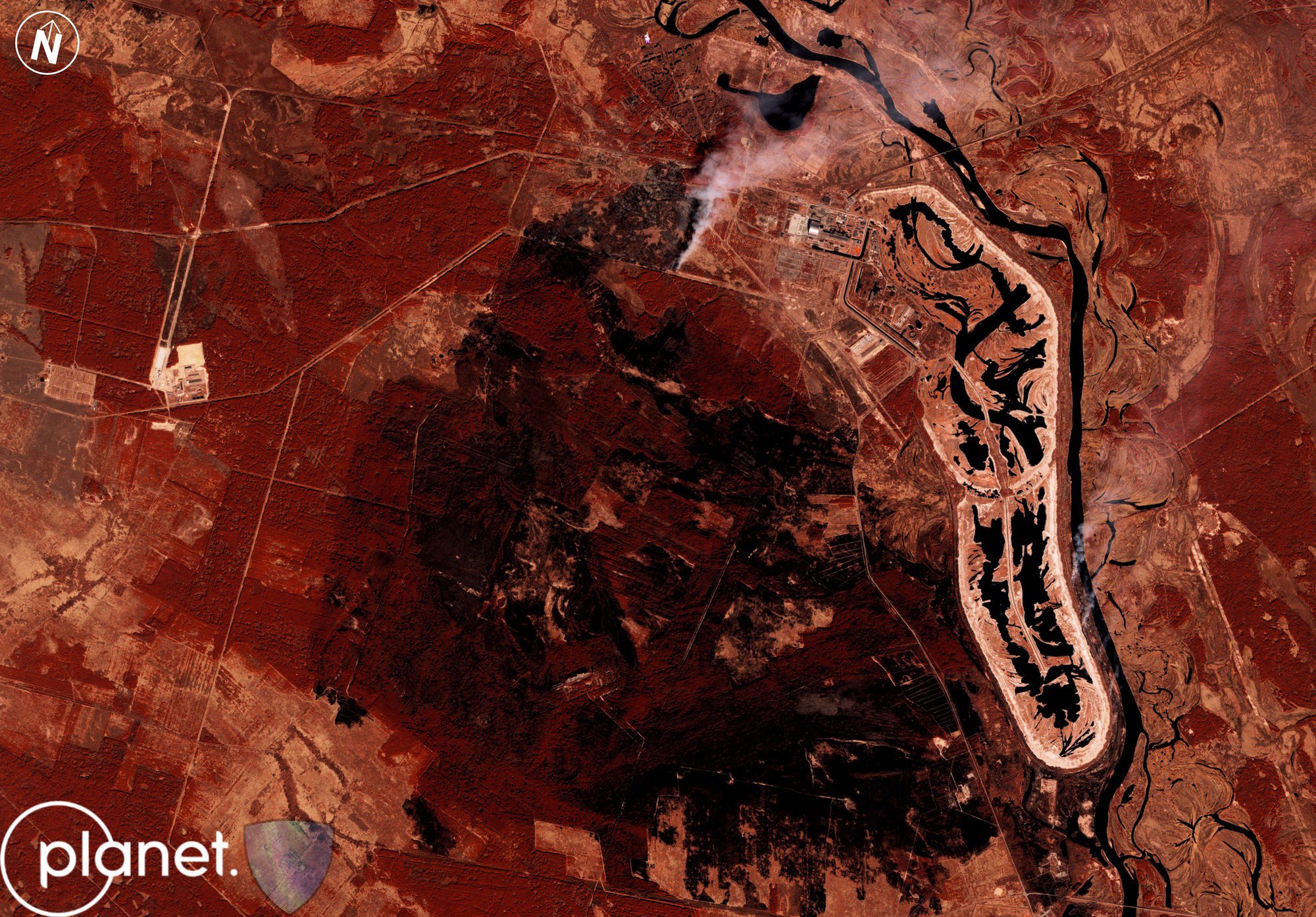
The massive efforts of firefighters, combined with the good luck of rainfall, resulted in containment of the fires on April 14, 2020 as is visible on this Planet Labs image, processed by @auroraintel
April 13, 2020, Planet Labs, False Colour rendering
Citizens have meanwhile expressed concerns that radioactivity in the exclusion zone could be spreading through thick smoke from the burning trees. Also, some international media outlets have made misleading claims about “spiking radiation levels” at the “abandoned nuclear waste storage” — with both of these statements actually being incorrect.
Some panic mongering/wrong facts/ conspiracy theories on wildfires near Chornobyl in last days https://t.co/mhtKKzbMZg
— Liveuamap (@Liveuamap) April 14, 2020
According to experts and government sources, the situation is more complicated than meets the eye. Local radiation levels seem to have increased, but there has been no immediate risk for citizens being exposed to dangerous levels of radiation. Using open source online tools such as the EU’s Joint Resource Centre Environmental Radioactivity Monitoring map, no increase of radiation is visible in the area in the period of the forest fires.
Naturally, fear of radiation is an understandable concern, as it’s invisible yet potentially lethal. The history of a lack of communication and transparency from those responsible for nuclear contamination incidents — be it waste, or meltdowns of reactors — only adds to heightened anxiety in the general population.
In the current situation, it is important to retain perspective. In the linked Kyiv Post article, for example, it is stated that a “radioactive cloud” will reach Kyiv, but the actual translation was “potential contaminated air masses,” which offers more nuance as to the risks that are currently involved.
As @fabrice_deprez mentioned the gov source mentions "potentially contaminated air masses", not a "radioactive cloud". There are many reasons to be worried BUT the government source cited in the viral tweet, currently says: no need "for additional radiation protection measures" pic.twitter.com/dFLM1ShIeK
— Oleksiy Kuzmenko (@kooleksiy) April 13, 2020
Imagery of prognoses shared on social media, as seen in the post above, also indicated the worst possible outcome with the fire not being extinguished, only exacerbating fears.
This Is Not The First Fire — Nor Is It The last
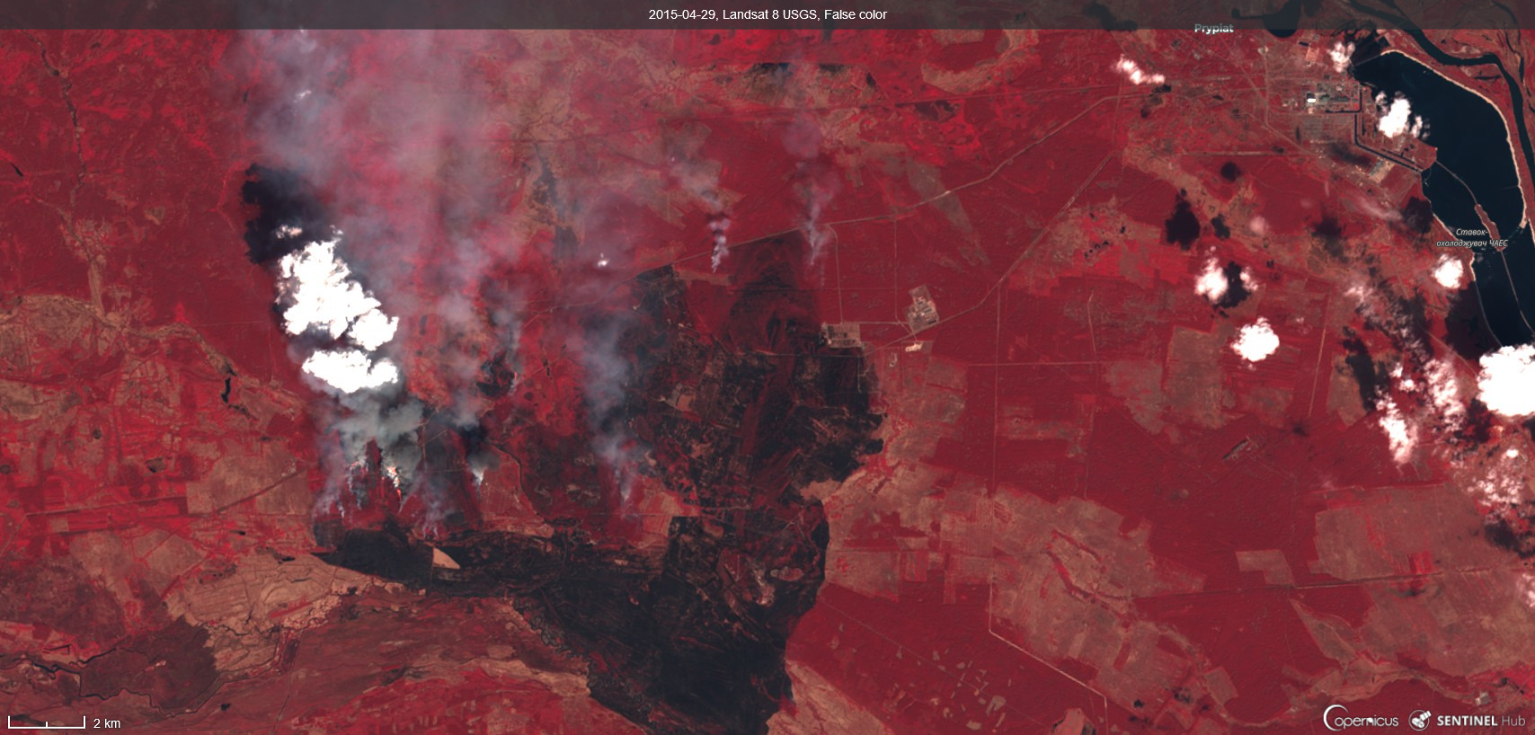
This isn’t the first time that the area has witnessed large forest fires. Satellite imagery from NASA in 2015 shows how the forest in the exclusion zone burned in both April and June of 2015.
Reports from that period indicate that over 120 firefighters were involved in containing the fire. In April of 2015, a large part of the forest west of the reactor burned down, as can be seen on this Landsat 8 satellite in False Color.
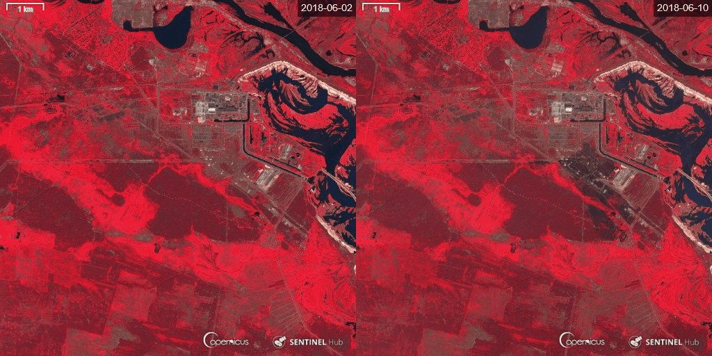
And in June of 2018, a wildfire came very close to the nuclear sarcophagus and burned down vegetation south-east of the facility, as can be seen on this Sentinel-2 imagery.
Real vs Perceived Risks?
The increase in forest fires — in particular, around vulnerable sites storing nuclear waste and in areas with a history of radioactive contamination — is a worrisome development.
And an increase in dry winter seasons as a result of climate change, making the forest more susceptible to forest fires, is a particular concern.
The fact that this has happened on multiple occasions over the last five years does not bode well for the future, and requires better planning for worst-case scenarios.
However, there isn’t any scientific evidence so far that demonstrates that these fires result in the release of radioactive clouds that pose a direct risk to human health. Continued air quality monitoring is needed to ensure that risks from the burning forest, in particular in the exclusion zones, are better understood — and timely and clear communication with citizens is needed to prevent fear and uncertainty.
Special thanks to @AuroraIntel and Planet Labs for providing the satellite imagery for this article and Michiel Driebergen @3bergen and @gennadius25 for additional social media information
