Geolocating Venezuelan Lawmakers In Europe
One of the newest chapters in the Venezuelan political saga involves a group of National Assembly lawmakers who were named in a report by the investigative news website Armando.Info alongside allegations that said lawmakers were involved in a corruption network. According to an investigation published by the website in December 2019, this group of lawmakers lobbied international institutions like the U.S. Department of the Treasury and the Colombian Office of the Attorney General in order to seek “indulgences” for individuals connected to the government of President Nicolas Maduro and who were themselves accused of corruption.
On January 19, 2020, Armando.Info published its newest findings on this case. The latest investigation revealed how these lawmakers traveled through Europe in the spring of 2019 in order to lobby on behalf of a group of individuals headed by Alex Saab, a central figure in a massive corruption case involving the Venezuelan government’s subsidized food distribution network.
While the legislators had admitted to traveling to Spain and Italy last year, the investigation by Armando.Info showed that they also secretly traveled to Portugal, Bulgaria and Liechtenstein, allegedly on errands on behalf of Saab and his companies. Part of the evidence of the lawmakers’ trip came from the geolocation of two images to Bulgaria and Switzerland. These images had been publicly available for months, but they had not been geolocated. When Armando.Info contacted Bellingcat for assistance with this task, their investigation into the case had already yielded some clues about where the images might have been captured.
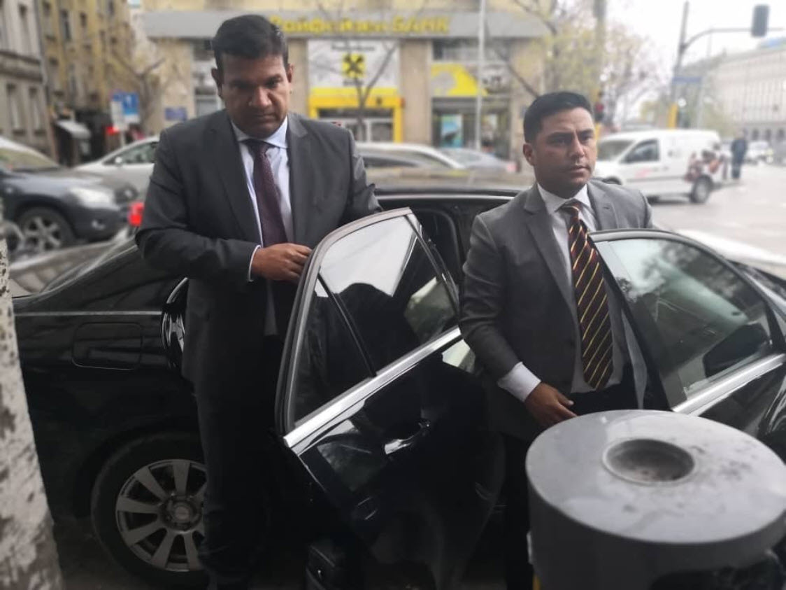
The first of these images shows deputies Conrado Pérez and Richard Arteaga exiting a vehicle in an urban centre somewhere. The image was rumoured to have been taken somewhere in Bulgaria in front of a bank:
The second image shows six deputies having their picture taken together alongside a journalist. As with the previous image, there were rumours that the image had been taken somewhere in Switzerland while the deputies were on their way to Liechtenstein:
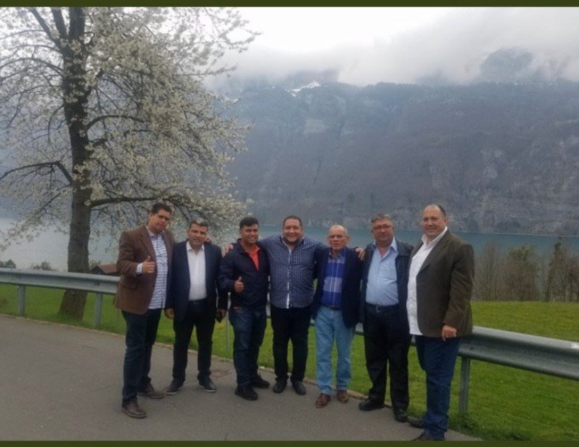
Journalist Carlos Herrera and deputies Luis Parra, Conrado Pérez, José Brito, Adolfo Superlano, José Luis Pirela, and Chaim Bucarán (Source: El Pitazo)
Geolocating each of these two images would add detail to the investigation being conducted by Armando.Info, as they would serve as evidence of the deputies’ movements in Europe.
This article shows the process, step-by-step, that resulted in the geolocation of these two images: the first to a street corner in front of a bank in Sofia, Bulgaria, and the second to a highway rest stop on the shores of Lake Walen in Switzerland.
The Bank In Sofia
The first image shows deputies Conrado Pérez and Richard Arteaga exiting a vehicle on a street, allegedly somewhere in Bulgaria in front of a bank. With this information, we can begin to geolocate the image. If the building behind the deputies is really a bank, then we should be able to find its logo — roughly two black sticks on a yellow background — somewhere online.
First, we conduct a Google search for “list of banks in Bulgaria”. The search provides many results, including this list that includes the names of several banks that operate in Bulgaria. By searching the names of each bank on Google Image Search to see their respective logos, we eventually reach “Raiffeisen Bank”, which yields the following results:
The Raiffeisen Bank logo appears to be a good candidate for the one that we can see behind the deputies in the picture.
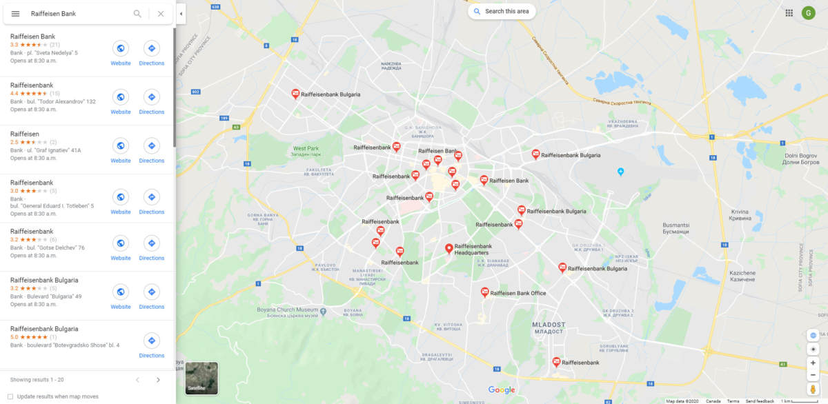
If the deputies were in Bulgaria, then it was likely that they would have gone to Sofia, the country’s capital. Starting on this assumption, we can search for “Raiffeisen Bank” on Google Maps in Sofia to determine if 1) there are Raiffeisen Bank branches in Sofia, and 2) if there are, whether the one in the picture of the deputies is among them.
Google Maps gives us 20 results for “Raiffeisen Bank” in Sofia:
From this point, the next step would be to check each of these locations on the map on Google Street View to see if any one of them is the one that is in the background of the image of the deputies. There is a way to make this task a little easier and faster than it might be ordinarily.
We can draw a sketch of what the scene behind the lawmakers might look like from above: that is to say, how might it look like on Google Maps? This sketch would have to include big details, like road layouts and buildings, and should omit small and/or mobile details like the positions of vehicles and people since the exact same ones seen in the picture are unlikely to appear in a satellite image.
Below, my sketch of what the scene in the picture of the deputies might look like on Google Maps:
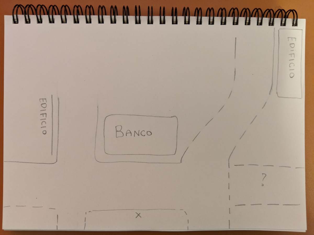
The “X” marks the spot where the person who took the picture would have been standing to take the picture of the deputies. The spotted lines include the presence of roads which, while not directly visible in the image, can be inferred
Note that the bank’s facade is the only one between two streets, and that the street that runs next to the bank on the right side of the image appears to curve into the background given the position of the vehicles on it.
With this sketch, we can quickly check each of the bank locations on Google Maps to see if any of them could be a candidate. Below is a compilation of three possibilities. Which one most closely resembles the sketch?

Three of the 20 results for the bank in Sofia given by Google Maps. By comparing our sketch to these options, the first one on the left should call our attention, given the narrow facade of the branch and the curved street on one of its sides (Source: Google)
Without having to check each branch one-by-one on Google Street View, we can eliminate the ones that are obviously different from our sketch. Of the three possibilities above, the first option is a good candidate since it shows a bank between two streets with a street that curves along one side of it.
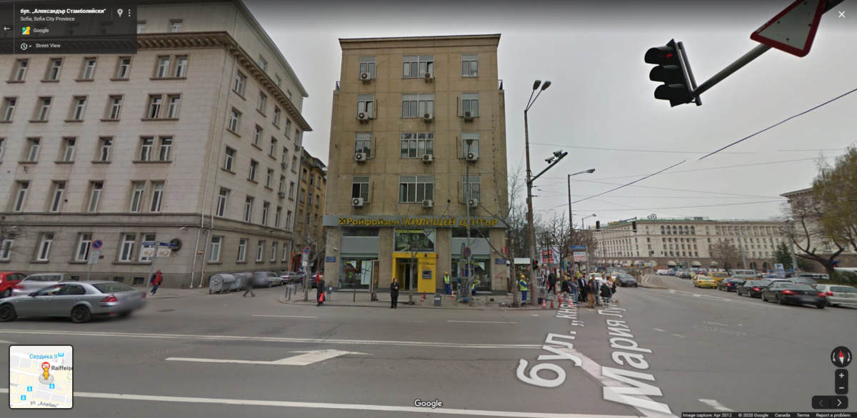
If we go to the Google Street View image of that location, we can see that it is the same one that is in the image of the deputies:
There is also a Google Street View image from this location dated June 2015, which was used to do the comparison below:
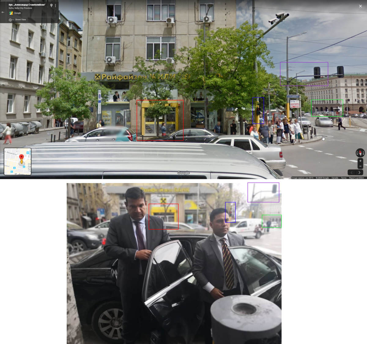
Note the bank’s facade (red box), the position of the traffic lights (purple and blue box), and the arcs on the building in the background (green box) (Source: Google)
There are also some small but notable differences between the two images above. The letters that spell out the bank’s name in the picture of the deputies take up less space than on the Google Street View imagery, and there is what appears to be a yellow awning to the right of the door of the bank. Sometimes, it is necessary to go to other sources for more recent reference images from a given location.
Mapillary is a website that allows us to access dashcam images taken by users around the world. If we go to this same street corner in Sofia on Mapillary, we can see that a user drove by this exact spot on January 26 2019 and captured the features in the bank’s storefront that we see in the picture of the deputies, as well as the trash can and the tree that are visible in the foreground of the image:
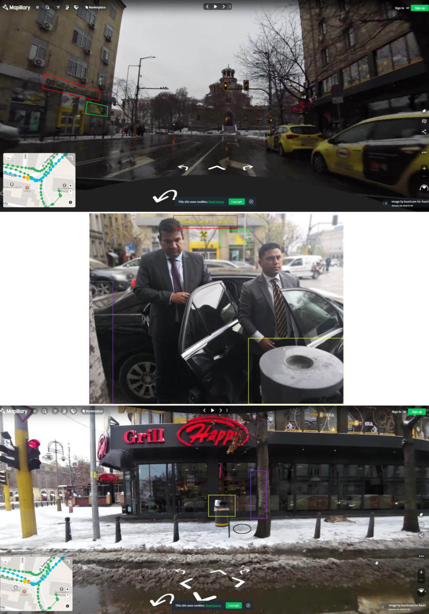
In these two images from Mapillary, we can see that the letters that spell out the name of the bank (red box) take up the same space as on the picture of the deputies, and that the yellow awning is also visible (green box). We can also see the garbage can (yellow box) and the tree (purple box) in the foreground of the picture, as well as the place where the person who took the picture was standing (black circle) (Source: Mapillary)
Having completed this geolocation, we can determine that these deputies were standing on this spot in Sofia, Bulgaria, when they had their picture taken.
The Rest Stop By Lake Walen
The second picture shows deputies, Parra, Pérez, Brito, Superlano, Pirela, and Bucarán somewhere picturesque alongside a journalist named Carlos Herrera. In the background we can see a body of water, like a river or a lake, along with a mountain. The information that accompanied the image suggested that it had been taken in the spring of 2019 in Switzerland, somewhere along a road that the deputies took to drive to Liechtenstein.
In order to geolocate this image, we begin with the allegation that it was taken somewhere along a road that connects Switzerland and Liechtenstein. Google Maps shows us that there are in fact several major roads that connect these two countries:
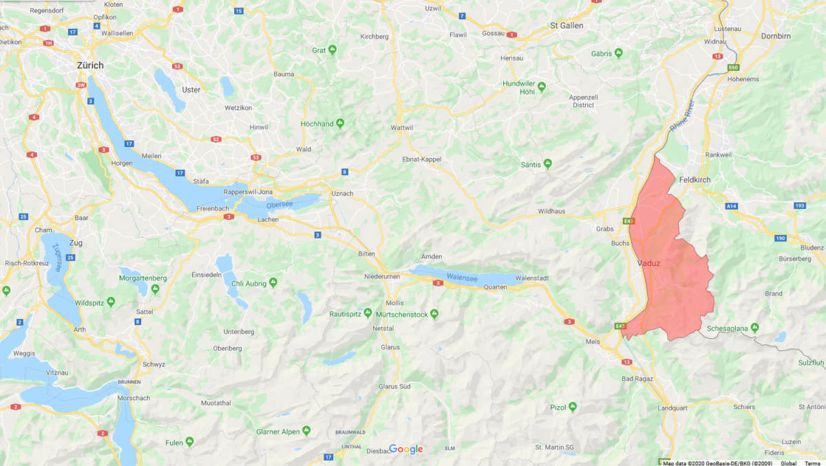
A map of the area border between Switzerland (on the left of the image) and Liechtenstein, which is highlighted in red (Source: Google)
Switzerland is home to many lakes, and we can begin to search those that are near main roads and that are flanked on at least one side by a mountain. Using Google Maps, we can navigate to the lakes in this area to see if any of them has these characteristics. Of the three options below, one stands out as a possible location:

There are three lakes in Switzerland that are near Liechtenstein that we can quickly check to see if they have the characteristics that we see in the picture. Above: Lakes Zurich (left), Constance (middle), and Walen (right) (Source: Google/Airbus, Maxar Technologies)
The lake on the right, Walen, is flanked by mountains. This makes it a good place to conduct a closer search to see if the deputies took their picture on its shores.
Although the resolution of the deputies’ picture is not very high, it still contains important details that we can use for the geolocation. In particular, there is a rock formation on the face of the mountain that could act as a unique identifier:
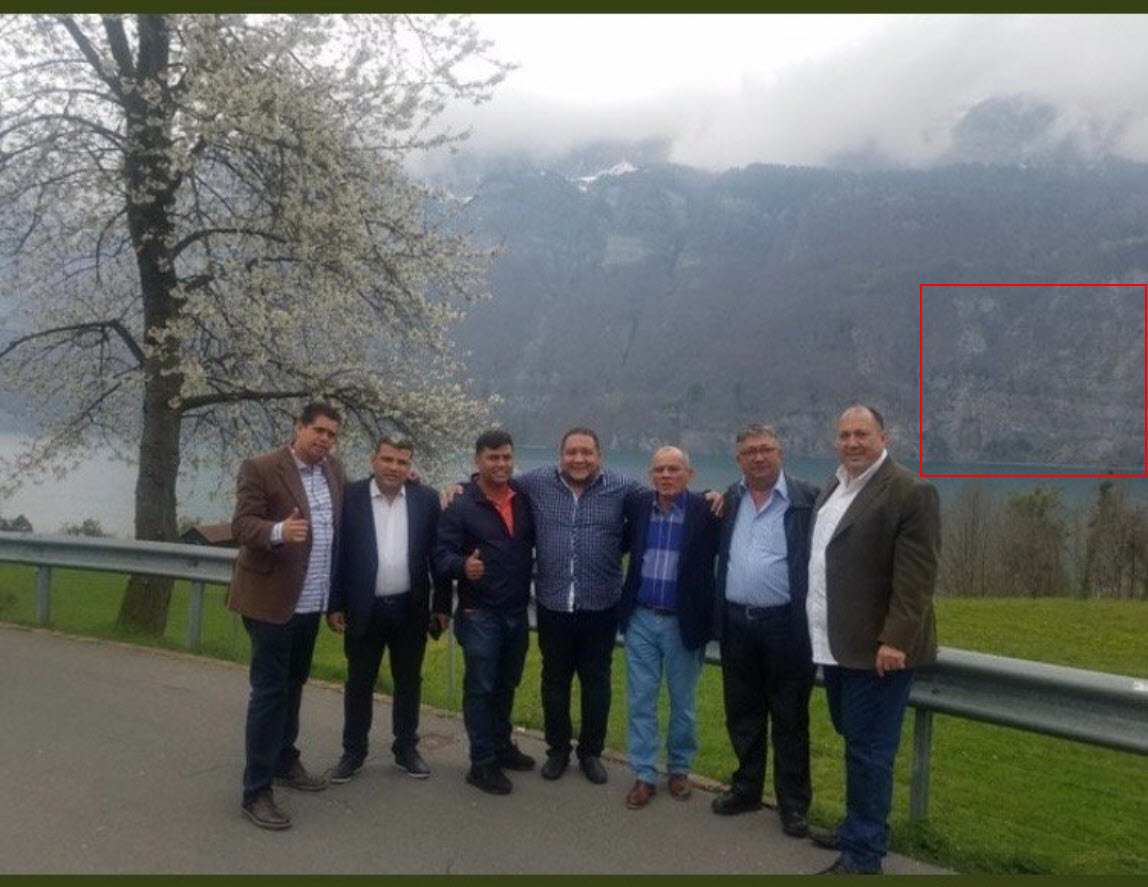
While the resolution of the image is low, this rock stratification (red box) could be visible on satellite imagery, which makes it a possible point of reference. Note the horizontal layering of the rocks
With this rock formation as reference, we can use Google Earth Pro to navigate to the lake and glide across the top of the road that runs across its southern shore to see if we can spot the formation. This is what that process looks like, resulting in a point of interest that we can check with other sources:
The rock formation on the face of the mountain that is visible at the end of the clip above is located here. As this rock formation called our attention, the next step is to look for reference images that show that same spot on the mountain. By going to the opposite shore of the lake on Google Maps, we can see that there is a logical spot where the image might have been taken: by a rest stop on the highway. It is not difficult to imagine that, on their journey on this highway, many people have stopped at this rest stop, used the washroom, stretched their legs, and taken a picture of the vista.
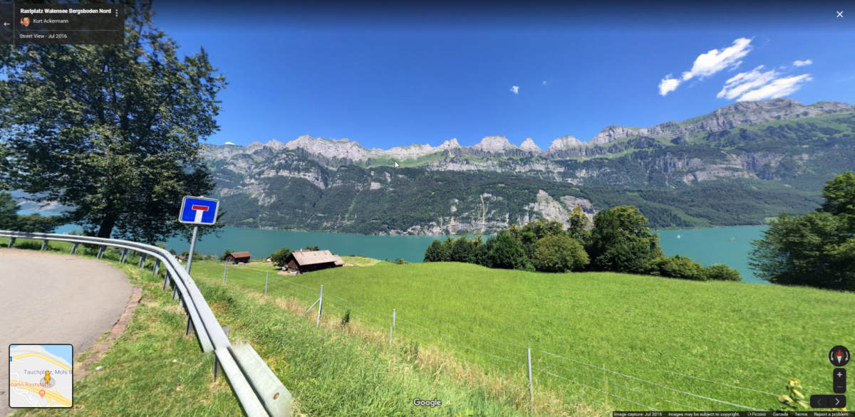
Some of those people have shared their images from this spot on Google Maps. Thanks to them, we can see what this location looks like from their point of view. The image below was taken at that location, showing the mountain, the lake, and our rock formation of interest in the background:
There are several pictures of the same location which contain elements that are visible in the picture of the deputies: not only the mountain and the lake behind them, but also the street, the guardrail, the tree to the right of the men, the grass and trees behind them, and the cabins in the distance. There are also more features on the mountain behind them that we can match to reference images:
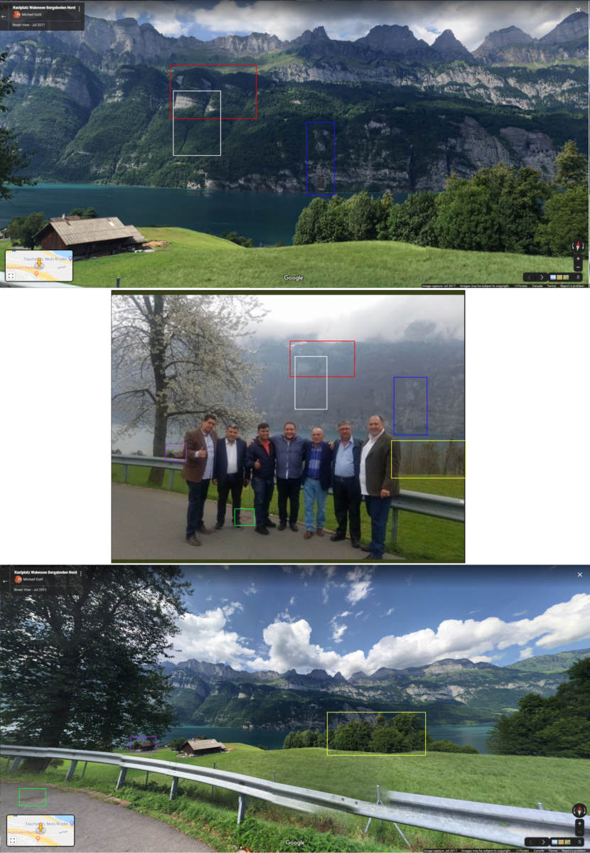
A comparison of the picture of the deputies and an image. Note in particular what appears to be a sewer/drainage cover (green box), marking the spot where the deputies posed to take their picture (Source: Google)
The tree with flowers behind the men is probably a variety of cherry blossom tree, which are famous for flowering in the spring—the season when Armando.Info suspected that the deputies had visited Switzerland and Liechtenstein.
Conclusion
Image geolocation is an important skill for open source investigators, given that it could contribute clues to investigations including confirmation of the movements of individuals. Image geolocation is rarely done “cold”: that is, we often have some clues regarding where an image was taken, even if those clues are rumours at first. In this case, the rumours that swirled around these images were enough to allow for a geolocation of where these lawmakers were photographed during their tour of Europe.
If you would like to practice your geolocation skills, follow Quiztime on Twitter, an account which regularly posts geolocation challenges.
With special thanks to Klement Anders for his help with this article.
